Lyttelton Playing Fields

Last updated
Playing fields Playing fields 2014-05-04 13-02.jpg
Playing fields

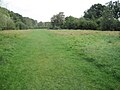
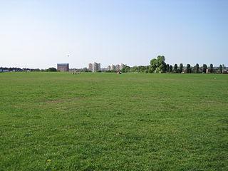
Lyttelton Playing Fields is a 9 hectare [1] public park in Hampstead Garden Suburb in the London Borough of Barnet. It is one of Barnet's 'Premier Parks'. [2]

Hampstead Garden Suburb suburb of Hampstead, United Kingdom

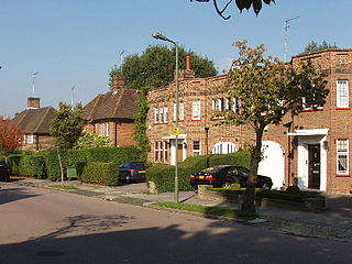
Hampstead Garden Suburb is an elevated suburb, north of Hampstead, west of Highgate and east of Golders Green. It is an example of early twentieth-century domestic architecture and town planning in the London Borough of Barnet in northwest London. The master plan was prepared by Barry Parker and Sir Raymond Unwin. Comprising just over 5,000 properties, and home to around 13,000 people, undivided houses of high value with individual gardens are a key feature. The area is dotted with landscaped garden squares or communal parks.

London Borough of Barnet Borough in United Kingdom

Barnet is a suburban London borough in North London, England. It forms part of Outer London and is the largest London borough by population with 384,774 inhabitants and covers an area of 86.74 square kilometres (33 sq mi), the fourth highest. It borders Hertfordshire to the north and five other London boroughs: Harrow and Brent to the west, Camden and Haringey to the southeast and Enfield to the east.

Contents

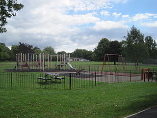
Most of the site is a large grassed area which can be used for cricket and football, and there are also a children's playground, tennis courts, multisport basketball and football courts, a private bowls club and toilets. [1] [3]

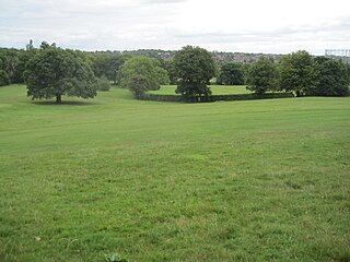
Mutton Brook goes along the north of the site through a small area of old woodland which is shown on Rocque's map of 1754, and was called Watery Wood in an 1864 Ordnance Survey map. The hedgerow along the southern edge once marked the boundary of the Bishop of London's Hornsey Park Estate. [1] There is a small 'Children's Millennium wood' in the north west corner. [4]

Mutton Brook river in London, United Kingdom

Mutton Brook is a stream which runs between East Finchley and Hendon in the London Borough of Barnet. It is a tributary of the River Brent, which is itself a tributary of the River Thames.

John Rocque surveyor and cartographer

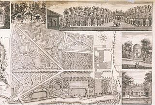
John Rocque was a surveyor and cartographer.

Ordnance Survey organisation that creates maps of Great Britain

Ordnance Survey (OS) is the national mapping agency of the United Kingdom which covers the island of Great Britain. Since 1 April 2015 part of Ordnance Survey has operated as Ordnance Survey Ltd, a government-owned company, 100% in public ownership. The Ordnance Survey Board remains accountable to the Secretary of State for Business, Energy and Industrial Strategy. It is also a member of the Public Data Group.

Lyttelton Playing Fields has an active friends group which secured Lottery funding in 2011 for renovation. [5] [6]

Access is from Kingsley Way, Lyttelton Road, Norrice Lea and Linden Lea.

See also

Related Research Articles

The London Borough of Barnet, located on the northern periphery of London and having much of the area within its boundaries in the Metropolitan Green Belt, has a large number of parks and open spaces. In addition there are large areas taken over by cemeteries and golf courses, and part of Hampstead Heath.

Mill Hill Park is a large public park in Mill Hill in the London Borough of Barnet. It one of Barnet's premier parks and it has been given a Green Flag Award.

Sunny Hill Park

Sunny Hill Park is in Hendon, in the London Borough of Barnet, England. It is a large hilly park, 22 hectares, mainly grassed, which has extensive views to the north and the west. Together with the neighbouring Hendon Churchyard, it is a Site of Local Importance for Nature Conservation.

Moat Mount Open Space

Moat Mount Open Space is a 110-hectare park and nature reserve in Mill Hill in the London Borough of Barnet. It is part of Moat Mount Open Space and Mote End Farm Site of Borough Importance for Nature Conservation, Grade II, which includes Barnet Gate Wood and Scratchwood Countryside Park, but is separate from Scratchwood itself, which is a neighbouring park and nature reserve. Most of the site is open to the public, but Mote End Farm and some other areas are private. Scratchwood and Moat Mount are a Local Nature Reserve.

Cherry Tree Wood

Cherry Tree Wood is a 5.3-hectare park in East Finchley in the London Borough of Barnet. It is a Site of Local Importance for Nature Conservation. Located opposite East Finchley Underground station, it contains woodland and grassland, a playground, tennis courts, a cafe and toilets.

Scratchwood

Scratchwood is an extensive, mainly wooded, country park in Mill Hill in the London Borough of Barnet. The 57-hectare site is a Site of Metropolitan Importance for Nature Conservation and together with the neighbouring Moat Mount Open Space it is a Local Nature Reserve.

Oak Hill Wood

Oak Hill Wood is a 10-hectare Local Nature Reserve (LNR) and a Site of Borough Importance for Nature Conservation Grade I, in East Barnet, London. It is owned by the London Borough of Barnet, and part of it is a 5.5-hectare nature reserve managed by the London Wildlife Trust.

Oak Hill Park (Barnet)

Oak Hill Park is in East Barnet in the London Borough of Barnet. It is one of Barnet's premier parks and received a Green Flag Award for 2009–10. It is a large area of parkland with a wide range of facilities, including an outdoor gym, a bowls green, football pitches, a golf course, three tennis courts, a multi-sports court and a play area for toddlers.

Friary Park park in Friern Barnet, London

Friary Park is a nine hectare formal Edwardian park in Friern Barnet in the London Borough of Barnet.

Princes Park, Temple Fortune

Princes Park is a small public park and Site of Local Importance for Nature Conservation in Temple Fortune in the London Borough of Barnet. It has two tennis courts and a children's playground.

Clitterhouse Recreation Ground

Clitterhouse Recreation Ground or Clitterhouse Playing Fields is a park and Site of Local Importance for Nature Conservation in Brent Cross in the London Borough of Barnet. It is a large area of mown grass with a children's playground, bordered by thick hedges. Clitterhouse Stream, a tributary of the River Brent, runs along its eastern border.

Old Court House Recreation Ground

Old Court House Recreation Ground is a public park in High Barnet in the London Borough of Barnet. It is one of the borough's Premier Parks and received a Green Flag Award for 2009-2010.

Watling Park is a public park in Burnt Oak in the London Borough of Barnet. It is one of Barnet's sixteen premier parks.

Childs Hill Park

Childs Hill Park is a public park in Childs Hill in the London Borough of Barnet. Together with the neighbouring Basing Hill Park, it is one of Barnet's 'Premier Parks'.

Basing Hill Park

Basing Hill Park is a small public park in Childs Hill in the London Borough of Barnet. Together with the neighbouring Childs Hill Park it is one of Barnet's 'Premier Parks'. It is mainly grassed with scattered trees, a multipurpose tennis court/football pitch, basketball court and a children's playground.

Victoria Recreation Ground, New Barnet

Victoria Recreation Ground is a public park in New Barnet in the London Borough of Barnet. It is one of Barnet's 'Premier Parks'.

West Hendon Playing Fields

West Hendon Playing Fields is a 62 acre public park in West Hendon in the London Borough of Barnet. It is one of Barnet's Premier Parks.

Brent Park (Hendon)

Brent Park is a small public park of 2.24 hectares in Hendon in the London Borough of Barnet. It is part of the 'Lower Dollis Brook' Site of Borough Importance for Nature Conservation, Grade II.

Tudor Sports Ground park in the United Kingdom

Tudor Sports Ground is a public park between Clifford Road and the East Coast Main Railway Line in New Barnet in the London Borough of Barnet. It is one of Barnet's 'Premier Parks'.

References

Coordinates: 51°35′01″N0°10′37″W / 51.5836°N 0.1769°W / 51.5836; -0.1769

Geographic coordinate system Coordinate system

A geographic coordinate system is a coordinate system that enables every location on Earth to be specified by a set of numbers, letters or symbols. The coordinates are often chosen such that one of the numbers represents a vertical position and two or three of the numbers represent a horizontal position; alternatively, a geographic position may be expressed in a combined three-dimensional Cartesian vector. A common choice of coordinates is latitude, longitude and elevation. To specify a location on a plane requires a map projection.