
Monte Sano State Park is a publicly owned recreation area and mountaintop retreat encompassing 2,140 acres (870 ha) on the eastern portion of the top and slopes of Monte Sano Mountain on the east side of Huntsville, Alabama. The state park has 1930s-era, Civilian Conservation Corps–built rustic cottages, hiking trails and picnic areas with scenic overlooks, and modern campsites. It is managed by the Alabama Department of Conservation and Natural Resources.

Canoe Creek State Park is a 911.91-acre (369.04 ha) Pennsylvania state park in Frankstown Township in Blair County, Pennsylvania. It is 12 miles east of Altoona, the nearest city. Canoe Lake, at 155 acres (63 ha), is the focus of recreation at the park and is open for fishing year-round. Canoe Creek State Park is a half mile off U.S. Route 22 near the small town of Canoe Creek. The park was opened to the public in 1979 and was developed as part of an expansion effort in the 1970s to improve the state park system in Pennsylvania.

Three Rivers Park District is a special park district serving the suburban areas of the Twin Cities including suburban Hennepin, Carver, Dakota, Scott and Ramsey counties. Three Rivers's mission is "To promote environmental stewardship through recreation and education in a natural resources-based park system." Three Rivers operates twenty parks and ten regional trails, with at least two more regional trails planned. Nearly seven million people visit Three Rivers facilities each year.

Onaway State Park is a public recreation area covering 158 acres (64 ha) on the southeast shore of Black Lake in North Allis Township, Presque Isle County, Michigan. The park sits at the end of M-211 five miles north of Onaway. Dedicated in 1921, it was one of the first 25 state parks created in Michigan. It contains sand and cobblestone beaches, large rock outcroppings, a campground, and nature trail highlighting a diversity of trees. The park was added to the National Register of Historic Places in 2009.

J.W. Wells State Park is a state park in the U.S. state of Michigan. The 678-acre (2.74 km2) park is located in Menominee County on the shore of Lake Michigan's Green Bay, just south of Cedar River. It is on M-35, roughly midway between Menominee and Escanaba. It was added to the National Register of Historic Places in 2002.

Big Pocono State Park is a 1,305.6-acre (528.4 ha) Pennsylvania state park in Jackson and Pocono townships in Monroe County, Pennsylvania in northeastern Pennsylvania in the United States. The park is on Camelback Mountain and is maintained jointly by the Pennsylvania Department of Conservation and Natural Resources and Camelback Ski Corporation.

Black Moshannon State Park is a 3,481-acre (1,409 ha) Pennsylvania state park in Rush Township, Centre County, Pennsylvania, United States. It surrounds Black Moshannon Lake, formed by a dam on Black Moshannon Creek, which has given its name to the lake and park. The park is just west of the Allegheny Front, 9 miles (14 km) east of Philipsburg on Pennsylvania Route 504, and is largely surrounded by Moshannon State Forest. A bog in the park provides a habitat for diverse wildlife not common in other areas of the state, such as carnivorous plants, orchids, and species normally found farther north. As home to the "[l]argest reconstituted bog/wetland complex in Pennsylvania".

North Bend State Park sits on 2,459 acres (995 ha) along the North Fork of the Hughes River in Ritchie County near Cairo, West Virginia. The park is named after the sharp bend in the river that the formed three sides of the original park boundary. The North Bend Rail Trail, a 72-mile (116 km) hiking and biking corridor, is also managed as a unit of the park. A new 305 acre (1.23 km²) lake was recently added to the park.

Sizerville State Park is a 386-acre (156 ha) Pennsylvania state park in Portage Township, Cameron County and Portage Township, Potter County, Pennsylvania in the United States. The park is nearly surrounded by Elk State Forest making it part of one of the largest blocks of state-owned land in Pennsylvania. Sizerville State Park is on Pennsylvania Route 155, six miles (10 km) north of the borough of Emporium.
Poe Valley State Park is a 620-acre (251 ha) Pennsylvania state park in Penn Township, Centre County, Pennsylvania in the United States. The park is surrounded by Bald Eagle State Forest. Poe Paddy State Park is 4 miles (6.4 km) to the east. The forests of the park surround the 25-acre (10 ha) Poe Lake. Poe Valley State Park is in isolated Poe Valley which lies between Potters Mills on U.S. Route 322 and Millheim on Pennsylvania Route 45. The park was closed during the 2008 and 2009 season while the lake was drained for dam repairs and the park facilities were upgraded.

White Pines Forest State Park, more commonly referred to as White Pines State Park, is an Illinois state park in Ogle County, Illinois. It is located near the communities of Polo, Mount Morris and Oregon. The 385-acre (156 ha) park contains the southernmost remaining stand of native white pine trees in the state of Illinois, and that area, 43 acres (17 ha), was designated an Illinois Nature Preserve in 2001.

Linn Run State Park is a Pennsylvania state park on 612 acres (248 ha) in Cook and Ligonier Townships, Westmoreland County, Pennsylvania in the United States. The park borders Forbes State Forest. Two smaller streams, Grove Run and Rock Run, join in Linn Run State Park to form Linn Run which has a waterfall, Adams Falls, which can be seen at the park. This state park is just off Pennsylvania Route 381 near the small town of Rector.

Tyler State Park is a state park north of Tyler, Texas. It is 985.5 acres (399 ha) in Smith County, north of Tyler. The park includes a 64-acre (26 ha) lake. The land was deeded by private owners in 1934 and 1935; original improvements were made by the Civilian Conservation Corps (CCC). The park opened in 1939.

New Germany State Park is a public recreation area covering 483 acres (195 ha) adjacent to Savage River State Forest in Garrett County, Maryland. The state park is administered by the Maryland Department of Natural Resources.
Sharon Johnston Park is a county park located in north Madison County, Alabama near New Market, Alabama, about 20 minutes from downtown Huntsville, Alabama. The park project was originated and developed by former county commission chairman James Record and the Madison County Commission in the 1970s. The Commission along with the Department of Conservation and Natural Resources entered into an agreement with the Johnston family, previous owners of the park property, to dedicate Sharon Johnston Memorial Park on June 4, 1979.

Village Creek State Park is a state park in the Piney Woods of eastern Texas in the Hardin County city of Lumberton. The heavily forested, 1,090 acres (441 ha) park opened in 1994. It is named for Village Creek, a clean, sand-bottomed, free-flowing tributary of the Neches River.
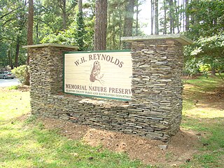
Reynolds Nature Preserve is a 146-acre (59 ha) tract of protected forest located in Morrow, Georgia, United States. The nature preserve is owned and operated by Clayton County Parks and Recreation. The park has three miles (5 km) of hiking trails, a Civil War era farm, native plants path, heritage garden, wildlife ponds, native azaleas, a wildflower field, and an interpretive center.
Fairfield Lake State Park is a state park located in Freestone County, Texas, northeast of Fairfield, Texas on the shores of Fairfield Lake. The park is 1,460 acres (591 ha).

Hobbs State Park – Conservation Area is a 12,056-acre (4,879 ha) Arkansas state park in Benton, Carroll, and Madison Counties, Arkansas in the United States. The park was bought in 1979 through a huge financial effort from Northwest Arkansas banks. Hobbs State Park – Conservation Area is located almost entirely in the Springfield Plateau subdivision of the Ozark Plateau. The park, located just south of Beaver Lake, is open for year-round recreation, including 32.9 miles (52.9 km) of hiking, mountain bike and equestrian trails. Hobbs State Park – Conservation Area also has several picnic areas, a shooting range, and primitive camping sites.


