Makana

Last updated
Makana Mountain ridge from Limahuli Garden and Preserve, Kauai, Hawaii Makana Mountain ridge from Limahuli Garden and Preserve, Kauai, Hawaii.JPG
Makana Mountain ridge from Limahuli Garden and Preserve, Kauai, Hawaii

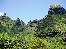
Makana is a mountain located on northern shore of the island of Kauaʻi, where it rises 1,115 feet (340 m) above Limahuli Valley. [1] Makana is a Hawaiian language term meaning gift or reward. [2] It is often used as a person's name or as part of a name. Limahuli Garden and Preserve preserves the valley below. [3] It was featured in the 1958 film adaptation of the musical South Pacific as Bali Haʻi, a name that is still used to this day. [4]

Kauai Island of the Hawaiian Island Chain

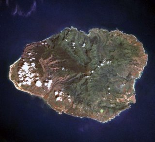
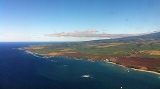
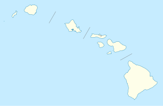
Kauaʻi, anglicized as Kauai, is geologically the oldest of the main Hawaiian Islands. With an area of 562.3 square miles (1,456.4 km2), it is the fourth-largest of these islands and the 21st largest island in the United States. Known also as the "Garden Isle", Kauaʻi lies 105 miles (169 km) across the Kauaʻi Channel, northwest of Oʻahu. This island is the site of Waimea Canyon State Park.

The Hawaiian language is a Polynesian language that takes its name from Hawaiʻi, the largest island in the tropical North Pacific archipelago where it developed. Hawaiian, along with English, is an official language of the State of Hawaii. King Kamehameha III established the first Hawaiian-language constitution in 1839 and 1840.

Limahuli Garden and Preserve botanical garden and nature preserve on the north shore of Kauaʻi island, Hawaiʻi

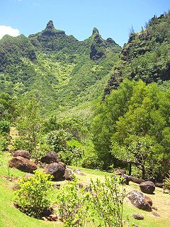
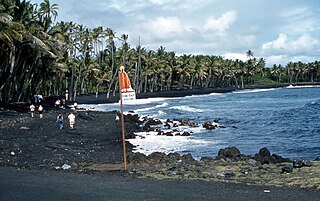
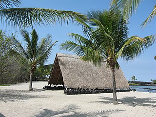
The Limahuli Garden and Preserve is a botanical garden and nature preserve on the north shore of Kauaʻi island, Hawaiʻi. It is one of the five gardens of the non-profit National Tropical Botanical Garden.

Makana Mountain is one of only two locations where the fire-throwing ceremony, ʻōahi, was performed in ancient Hawaiian times. [5] The ʻōahi was a celebration of very special occasions such as the graduation of students from the hālau hula (hula school) at ʻē or the visit of an aliʻi (high chief). On the day of the ceremony, skilled firethrowers climbed the steep cliffs to the very top of Makana Mountain laden with light, dry logs of pāpala ( Charpentiera spp.) or hau ( Hibiscus tiliaceus ). When night fell, they set the logs afire and hurled them out over the ocean. Ridge lifts created by trade winds hitting the sheer cliff of Makana kept the firebrands aloft, soaring as far as 1 mi (1.6 km) out to sea. The result was a night sky filled with sparks and fiery torches tracing long arcs of light. [3] It is sometimes called "Fireworks Cliff". [6]

Ancient Hawaii culture in the Hawaiian Islands preceding the unification of the Kingdom of Hawaiʻi in 1810

Ancient Hawaiʻi is the period of Hawaiian human history preceding the unification in 1810 of the Kingdom of Hawaiʻi by Kamehameha the Great. Traditionally researchers estimated the first settlement of the Hawaiian islands by Polynesian long-distance navigators from French Polynesia, Tahiti, the Tuamotus and the Samoan Islands as having occurred sporadically between 300 and 800 CE. In 2010, a study was published based on radiocarbon dating of more reliable samples which suggests that the islands were settled much later, within a short timeframe, in about 1219 to 1266.

A hālau hula is a school in which the ancient Hawaiian dance form called hula is taught. The term comes from hālau, a workshed, and hula, the traditional dance of the Hawaiian Islands.

Hula Polynesian dance

Hula is a Polynesian dance form accompanied by chant (oli) or song. It was developed in the Hawaiian Islands by the Polynesians who originally settled there. The hula dramatizes or portrays the words of the oli or mele in a visual dance form.

People in canoes would crowd the ocean below Makana, trying to catch the firebrands. It was considered heroic to catch the flaming embers, and those who succeeded would often mark themselves with the fire in honor of the occasion. Couples who caught the firebrands would both mark themselves in the same way, as a sign of love and commitment.

The practice ended in the 19th century, with the last ceremony having been in honor of Queen Emma.

Related Research Articles

Kaimū, Hawaii human settlement in Hawaii County, Hawaii, United States of America

Kaimū was a small town in the Puna District on Island of Hawaiʻi that was completely destroyed by an eruptive flow of lava from the Kūpaʻianahā vent of the Kīlauea volcano in 1990. In Hawaiian, kai mū means "gathering [at the] sea" as to watch surfing. The lava flow that destroyed Kaimū and nearby Kalapana erupted from the southeast rift zone of Kīlauea.

ʻIolani Barracks barracks in Honolulu, Hawaii, United States

ʻIolani Barracks, or hale koa in Hawaiian, was built in 1870, designed by the architect Theodore Heuck, under the direction of King Lot Kapuaiwa. Located directly adjacent to ʻIolani Palace in downtown Honolulu, it housed about 80 members of the monarch's Royal Guard until the overthrow of the Monarchy in 1893. It was added to the National Register of Historic Places in 1978 as part of the Hawaii Capital Historic District.

Makahiki Ancient Hawaiian season of New Year festival

The Makahiki season is the ancient Hawaiian New Year festival, in honor of the god Lono of the Hawaiian religion.

ʻĀina Haina is an unincorporated town of the City & County of Honolulu in the state of Hawaiʻi of the United States. Located on the island of Oʻahu, ʻĀina Haina is a residential community developed around Kalanianaole Highway east of Waikīkī and Diamond Head. ʻĀina Haina was named after local dairyman and owner of Hind-Clarke Dairy, Robert Hind. ʻĀina Haina in the Hawaiian language means "Hind's Land". A main street is a loop named Hind Drive for him. ʻĀina Haina has two elementary schools and a shopping center.

Haiku, Hawaii Unincorporated community in Hawaii, United States

Haiku is an unincorporated community in Maui County on the island of Maui in the state of Hawaii. For United States Census purposes, it is part of the Haiku-Pauwela, Hawaii census-designated place, which also includes Pauwela.

Honokōhau Settlement and Kaloko-Honokōhau National Historical Park Historic Place in Hawaii County, Hawaii

Kaloko-Honokōhau National Historical Park is a United States National Historical Park located in the Kona District on the Big island of Hawaiʻi in the U.S. state of Hawaiʻi. It includes the National Historic Landmarked archaeological site known as the Honokōhau Settlement. The park was established on November 10, 1978, for the preservation, protection and interpretation of traditional native Hawaiian activities and culture.

Pulu

Pulu is a silky material obtained from the fibers of the hapuʻu pulu, a tree fern of Hawaii. It is made of the brown hairs that cover the young fiddlehead as it uncoils.

Haʻena State Park

Hāʻena State Park is a state park located on the north shore of the Hawaiian island of Kauaʻi. It is often referred to as the "end of the road" and marks the end point of the Kuhio Highway. The park provides access to beaches, trails, and several ancient Hawaiian sites, including sea caves estimated to be more than 4,000 years old. Archaeological sites associated with the hula, including a heiau (shrine) dedicated to Laka, are located above the park's beaches.

Kēōkea is an unincorporated populated place in Hawaii County, Hawaii, United States. It is located at 19°25′10″N155°52′58″W, near the junction of Māmalahoa Highway and Keala o Keawe Road, elevation 960 feet. Satellite imagery shows evidence of a humid climate with agriculture dominant around the settlement. Just to the north is the area of Hōnaunau. It was the name for the land division (ahupuaa) of ancient Hawaii that stretched from the shoreline to Mauna Loa owned by Mataio Kekūanāoa.

Samuel M. Spencer American politician

Spencer Beach Park is a county park named for Hawaiʻi island politician Samuel Mahuka Spencer (1875–1960).

Hawaiian flagtail genus of fishes

The Hawaiian flagtails are species of the genus of flagtail fishes found in the Hawaiian Islands. Two species are Kuhlia sandvicensis and K. xenura. K. xenura is endemic to the islands.

Kamanawa II known as Kamanawa ʻŌpio or Kamanawa ʻElua was a Hawaiian high chief and grandfather of the last two ruling monarchs of the Kingdom of Hawaii, King David Kalākaua and Queen Lydia Makaeha Liliʻuokalani. His family had a good reputation until 1840, when he was convicted of murdering his wife.

Kealia, Hawaii Unincorporated community in Hawaii, United States

Kealia is an unincorporated community on the island of Kauai in Kauai County, Hawaii, United States. Its elevation is 16 feet (5 m). The Board on Geographic Names officially designated it "Kealia" in 1914. Although it is unincorporated, it has a post office, with the ZIP code of 96751. James Wood Bush, a Hawaiian veteran of the American Civil War and later Mormon convert was a resident of Kealia.

Nīnole, Hawaii unincorporated community in Hawaii, United States

Nīnole is the name of two unincorporated communities on the island of Hawaiʻi in Hawaii County, Hawaii, United States. In the Hawaiian language Nīnole means "bending". Ninole also has the highest percentage of people of Italian descent in Hawaii.

Moloaʻa Bay is on the northeast shore on the island of Kauaʻi in Hawaii. The bay is 0.44 miles (710 m) long.

Waimea High School is a public high school in Waimea on the island of Kauaʻi in the state of Hawaii. It was established in 1881 and serves grades 9 through 12. It is the westernmost high school in the United States of America. The school mascot is the Menehune, and the school colors are blue and white.

Paauhau, Hawaii Unincorporated community in Hawaii, United States

Paauhau is an unincorporated community on the island of Hawaiʻi in Hawaii County, Hawaii, United States. Paauhau is located near the north coast of the island, 2 miles (3.2 km) east-northeast of Honokaʻa.

Kanikapila is a style of Hawaiian music produced in an impromptu jam session, most commonly taking place at a beach, or family gathering. The term comes from kani which means sound. and pila which means any string instrument in the Hawaiian language.

Kawaikini mountain

Kawaikini is the highest point on the Hawaiian Island of Kauai and in Kauai County and measures 5,243 feet (1,598 m) in elevation. It is the summit of the island's inactive central shield volcano, Mount Waialeale. Other peaks on Kauai include: Waialeale, Namolokama Mountain, Kalalau Lookout, Keanapuka Mountain, Haupu and Nounou.

References

  1. U.S. Geological Survey Geographic Names Information System: Makana
  2. Mary Kawena Pukui and Samuel Hoyt Elbert (2003). "lookup of Makana". in Hawaiian Dictionary. Ulukau, the Hawaiian Electronic Library, University of Hawaii Press . Retrieved September 23, 2010.
  3. 1 2 "Take a tour of the Limahuli Garden!". Limahuli Garden and Preserve. National Tropical Botanical Garden . Retrieved 2009-11-06.
  4. Jeanne Cooper (March 27, 2009). "'Bali Hai' still calling visitors to Hawaii". San Francisco Chronicle . Retrieved September 23, 2010.
  5. Mary Kawena Pukui and Samuel Hoyt Elbert (2003). "lookup of ʻōahi". in Hawaiian Dictionary. Ulukau, the Hawaiian Electronic Library, University of Hawaii Press . Retrieved September 23, 2010.
  6. Mary Kawena Pukui, Samuel Hoyt Elbert and Esther T. Mookini (2004). "lookup of Makana ". in Place Names of Hawai'i. Ulukau, the Hawaiian Electronic Library, University of Hawaii Press . Retrieved September 23, 2010.

Coordinates: 22°13′5″N159°34′47″W / 22.21806°N 159.57972°W / 22.21806; -159.57972

Geographic coordinate system Coordinate system

A geographic coordinate system is a coordinate system that enables every location on Earth to be specified by a set of numbers, letters or symbols. The coordinates are often chosen such that one of the numbers represents a vertical position and two or three of the numbers represent a horizontal position; alternatively, a geographic position may be expressed in a combined three-dimensional Cartesian vector. A common choice of coordinates is latitude, longitude and elevation. To specify a location on a plane requires a map projection.