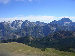
The Stuart Range is a mountain range in central Washington, United States. The range lies within the eastern extent of the Cascade Range immediately southwest of Leavenworth and runs east-west. The western peaks make up a single sharp ridge. The eastern half of the range splits into two parallel ridges, the northern of which is known as the Enchantment Peaks. Between these ridges lies the Enchantment Basin, which holds the dozens of tarns known as the Enchantment Lakes. Collectively, the basin and the encircling eastern peaks of the Stuart Range make up The Enchantments, a well-known backpacking destination. The south face of the Stuart Range falls off steeply to Ingalls Creek, beyond which rise the roughly parallel Wenatchee Mountains.
Mel's Hole is, according to an urban legend, an allegedly "bottomless pit" near Ellensburg, Washington. Claims about it were first made on the radio show Coast to Coast AM by a guest calling himself "Mel Waters." Later investigation revealed no such person was listed as residing in that area and no credible evidence that the hole exists.
Passive radar systems encompass a class of radar systems that detect and track objects by processing reflections from non-cooperative sources of illumination in the environment, such as commercial broadcast and communications signals. It is a specific case of bistatic radar, the latter also including the exploitation of cooperative and non-cooperative radar transmitters.

Manastash Ridge is a long anticline mountain ridge located in central Washington state in the United States. Manastash Ridge runs mostly west-to-east in Kittitas and Yakima counties, for approximately 50 miles. The ridge is part of the Yakima Fold Belt of east-tending long ridges formed by the folding of Miocene Columbia River basalt flows.
The W band of the microwave part of the electromagnetic spectrum ranges from 75 to 110 GHz, wavelength ≈2.7–4 mm. It sits above the U.S. IEEE-designated V band (40–75 GHz) in frequency, and overlaps the NATO designated M band (60–100 GHz). The W band is used for satellite communications, millimeter-wave radar research, military radar targeting and tracking applications, and some non-military applications.

The Horse Heaven Hills AVA is an American Viticultural Area in southeastern Washington, and is part of the larger Columbia Valley AVA. The Horse Heaven Hills AVA borders the Yakima Valley AVA on the north and the Columbia River on the south. Elevations in this AVA range from 200 feet (61 m) above sea level in the south to 1,800 feet (549 m) above sea level at the northern boundary. Grapes planted in the south-facing slopes of the Horse Heaven Hills benefit from strong winds that arrive from the west via the Columbia Gorge, reducing the likelihood of rot and fungal diseases.

The Manastash Ridge Observatory (MRO) is an astronomical observatory built in 1972 by the University of Washington. It is located in a remote area approximately 14 kilometers (8.7 mi) west of Ellensburg, Washington, and can be reached by dirt roads from Ellensburg or Selah. The observatory features a 0.75 m (30 in) Ritchey-Chrétien telescope built by Boller and Chivens. Initially used for professional and graduate research, the observatory is now used mostly by undergraduate students for instruction and research. For a brief time there was talk of stopping funding for MRO as the University of Washington Astronomy Department focus on the Apache Point Observatory, but funding did continue and MRO is still in use.
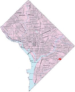
Fairfax Village is a small neighborhood of garden apartments and townhouses located in southeast Washington, D.C. in the Hillcrest area. It is bound by Alabama Avenue SE to the northwest, Pennsylvania Avenue SE to the northeast, Suitland Road to the southwest, and Southern Avenue to the east.
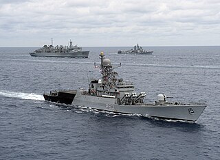
Kora-class corvettes are 1,350-tonne guided missile corvettes, in active service with the Indian Navy. Four vessels were built at Garden Reach Shipbuilders and Engineers (GRSE) and outfitted at Mazagon Dock Limited (MDL).
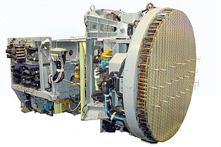
The Bars (Leopard) is a family of Russian all-weather multimode airborne radars developed by the Tikhomirov Scientific Research Institute of Instrument Design for multi-role combat aircraft such as the Su-27 and the MiG-29.

Umtanum Ridge Water Gap is a geologic feature in central Washington state in the United States. It was designated a National Natural Landmark in 1980.

The Yakima Training Center (YTC) is a United States Army training center, used for maneuver training, Land Warrior system testing and as a live fire exercise area. It is located in the south central portion of the U.S. state of Washington, bounded on the west by Interstate 82, on the south by the city of Yakima, on the north by the city of Ellensburg and Interstate 90, and on the east by the Columbia River. It is a part of Joint Base Lewis-McChord. It comprises 327,000 acres of land, most of which consists of shrub-steppe, making it one of the largest areas of shrub-steppe habitat remaining in Washington state. The terrain is undulating and dominated by three east-west parallel ridges, the Saddle Mountains, Manastash Ridge, and Umtanum Ridge anticlines, which are part of the Yakima Fold Belt near the western edge of the Columbia River Plateau. Vegetation consists of sagebrush, bitterbrush, and bunch grass. Vagabond Army Airfield and Selah Airstrip are located on the Yakima Training Center. The training center is also used by the Japan Ground Self-Defense Force for exercises.

Ahtanum Ridge is a long anticline mountain ridge in Yakima County in the U.S. state of Washington. It is located just south of the city of Yakima, and much of its length is at the northern edge of the Yakama Indian Reservation.

Umtanum Ridge is a long anticline mountain ridge in Yakima County and Kittitas County in the U.S. state of Washington. It runs for approximately 55 miles east-southeast from the Cascade Range, through the Yakima Training Center to the edge of the Columbia River at Priest Rapids Dam and Hanford Reach. The eastern end of Umtanum Ridge enters Hanford Reach National Monument and the Hanford Site. Umtanum Ridge is paralleled on the north by Manastash Ridge and on the south by Yakima Ridge. The Yakima River cuts through the ridge at the Umtanum Ridge Water Gap.
Snipes Mountain AVA is an American Viticultural Area located in the Yakima Valley of Washington State. It was approved by the Bureau of Alcohol, Tobacco, Firearms and Explosives on January 21, 2009 making it Washington's 10th federally designated AVA. It is the second smallest AVA in the state, after the Red Mountain AVA, and has one of the state's longest viticultural histories. The 4,145 acres (1,677 ha) appellation is a sub-AVA of the Yakima Valley AVA and the Columbia Valley AVA. It is located above and between the towns of Sunnyside and Granger around Outlook, Washington, in the southeast corner of the Yakima Valley.

Colville Air Force Station is a closed United States Air Force General Surveillance Radar station. It is located 14.7 miles (23.7 km) east-northeast of Colville, Washington. It was closed in 1961.
Othello Air Force Station is a closed United States Air Force General Surveillance Radar station. It is located 7.2 miles (11.6 km) south of Othello, Washington. It was the home station of the 637th Aircraft Control and Warning Squadron and the 637th Air Defense Group, closing in 1975.
Blaine Air Force Station is a closed United States Air Force General Surveillance Radar station. It is located 5.5 miles (8.9 km) south of Blaine, Washington. It was closed in 1979.

Red Cliff Air Station was a General Surveillance Radar station. The remains of which are located 5.8 miles (9.3 km) north-northeast of St. John's, Newfoundland and Labrador, Canada. It was closed in 1961.
Selah Gap is a water gap carved by the Yakima River through the Yakima Ridge basalt formation between Yakima, Washington and Selah, Washington. The gap is traversed by BNSF Railway, Interstate 82, and Washington State Route 823. The Yakima Greenway trail for non motorized users also crosses the Yakima River at Selah Gap on an 1884 railroad bridge. The William O. Douglas Trail, named for William O. Douglas who hiked there from his home in Yakima, also crosses the gap and ascends the ridge on its way to Mount Rainier.