
Microsoft Access is a database management system (DBMS) from Microsoft that combines the relational Access Database Engine (ACE) with a graphical user interface and software-development tools. It is a member of the Microsoft 365 suite of applications, included in the Professional and higher editions or sold separately.
SVG is an XML-based vector image format for defining two-dimensional graphics, having support for interactivity and animation. The SVG specification is an open standard developed by the World Wide Web Consortium since 1999.
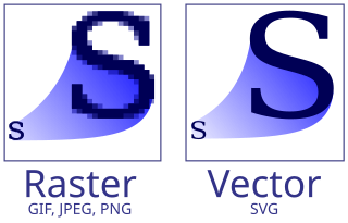
Vector graphics are a form of computer graphics in which visual images are created directly from geometric shapes defined on a Cartesian plane, such as points, lines, curves and polygons. The associated mechanisms may include vector display and printing hardware, vector data models and file formats, as well as the software based on these data models. Vector graphics is an alternative to raster or bitmap graphics, with each having advantages and disadvantages in specific situations.
Environmental Systems Research Institute, Inc., doing business as Esri, is an American multinational geographic information system (GIS) software company headquartered in Redlands, California. It is best known for its ArcGIS products. With a 40% market share, Esri is the world's leading supplier of GIS software, web GIS and geodatabase management applications.
In computer programming, create, read, update, and delete (CRUD) are the four basic operations of persistent storage. CRUD is also sometimes used to describe user interface conventions that facilitate viewing, searching, and changing information using computer-based forms and reports.
A GIS file format is a standard for encoding geographical information into a computer file, as a specialized type of file format for use in geographic information systems (GIS) and other geospatial applications. Since the 1970s, dozens of formats have been created based on various data models for various purposes. They have been created by government mapping agencies, GIS software vendors, standards bodies such as the Open Geospatial Consortium, informal user communities, and even individual developers.
In the Microsoft Windows operating system, index.dat is a hidden database file used by the Internet Explorer web browser. It functions as an information storage database of recent browser activity, enabling quick access to that information when needed again by Internet Explorer, thus improving browser performance.
Microsoft WinHelp is a proprietary format for online help files that can be displayed by the Microsoft Help browser winhelp.exe or winhlp32.exe. The file format is based on Rich Text Format (RTF). It remained a popular Help platform from Windows 3.0 through Windows XP. WinHelp was removed in Windows Vista purportedly to discourage software developers from using the obsolete format and encourage use of newer help formats. Support for WinHelp files would eventually be removed entirely in Windows 10.
A GIS software program is a computer program to support the use of a geographic information system, providing the ability to create, store, manage, query, analyze, and visualize geographic data, that is, data representing phenomena for which location is important. The GIS software industry encompasses a broad range of commercial and open-source products that provide some or all of these capabilities within various information technology architectures.
A number of vector graphics editors exist for various platforms. Potential users of these editors will make a comparison of vector graphics editors based on factors such as the availability for the user's platform, the software license, the feature set, the merits of the user interface (UI) and the focus of the program. Some programs are more suitable for artistic work while others are better for technical drawings. Another important factor is the application's support of various vector and bitmap image formats for import and export.
In computer graphics, image tracing, raster-to-vector conversion or raster vectorization is the conversion of raster graphics into vector graphics.

Graphic art software is a subclass of application software used for graphic design, multimedia development, stylized image development, technical illustration, general image editing, or simply to access graphic files. Art software uses either raster or vector graphic reading and editing methods to create, edit, and view art.

gvSIG, geographic information system (GIS), is a desktop application designed for capturing, storing, handling, analyzing and deploying any kind of referenced geographic information in order to solve complex management and planning problems. gvSIG is known for having a user-friendly interface, being able to access the most common formats, both vector and raster ones. It features a wide range of tools for working with geographic-like information.
MapInfo Pro is a desktop geographic information system (GIS) software developed by Precisely, used for mapping and location analysis. It was formerly developed by Pitney Bowes Software and the MapInfo Corporation.
ArcMap is the former main component of Esri's ArcGIS suite of geospatial processing programs. Used primarily to view, edit, create, and analyze geospatial data. ArcMap allows the user to explore data within a data set, symbolize features accordingly, and create maps. This is done through two distinct sections of the program, the table of contents and the data frame. In October 2020, it was announced that there are no plans to release 10.9 in 2021, and that ArcMap would no longer be supported after March 1, 2026. Esri is encouraging their users to transition to ArcGIS Pro.
FastPictureViewer is a freemium image viewer for Windows XP and later. Its aim is to facilitate quick review, rating and annotation of large quantities of digital images in the early steps of the digital workflow, with an emphasis on simplicity and speed. As an app with a freemium license, a basic version is available cost-free for personal, non-profit or educational uses, while a commercial license is required for the professional version with additional features. The basic version starts as a full version trial.
A geographic data model, geospatial data model, or simply data model in the context of geographic information systems, is a mathematical and digital structure for representing phenomena over the Earth. Generally, such data models represent various aspects of these phenomena by means of geographic data, including spatial locations, attributes, change over time, and identity. For example, the vector data model represents geography as collections of points, lines, and polygons, and the raster data model represent geography as cell matrices that store numeric values. Data models are implemented throughout the GIS ecosystem, including the software tools for data management and spatial analysis, data stored in a variety of GIS file formats, specifications and standards, and specific designs for GIS installations.
data2map is a presentation mapping service provider based in Saalfelden am Steinernen Meer, Salzburg, Austria.
Vector tiles, tiled vectors or vectiles are packets of geographic data, packaged into pre-defined roughly-square shaped "tiles" for transfer over the web. This is an emerging method for delivering styled web maps, combining certain benefits of pre-rendered raster map tiles with vector map data. As with the widely used raster tiled web maps, map data is requested by a client as a set of "tiles" corresponding to square areas of land of a pre-defined size and location. Unlike raster tiled web maps, however, the server returns vector map data, which has been clipped to the boundaries of each tile, instead of a pre-rendered map image.