
A fishing weir, fish weir, fishgarth or kiddle is an obstruction placed in tidal waters, or wholly or partially across a river, to direct the passage of, or trap fish. A weir may be used to trap marine fish in the intertidal zone as the tide recedes, fish such as salmon as they attempt to swim upstream to breed in a river, or eels as they migrate downstream. Alternatively, fish weirs can be used to channel fish to a particular location, such as to a fish ladder. Weirs were traditionally built from wood or stones. The use of fishing weirs as fish traps probably dates back prior to the emergence of modern humans, and have since been used by many societies across the world.

The National Register of Historic Places in the United States is a register including buildings, sites, structures, districts, and objects. The Register automatically includes all National Historic Landmarks as well as all historic areas administered by the U.S. National Park Service. Since its introduction in 1966, more than 90,000 separate listings have been added to the register.

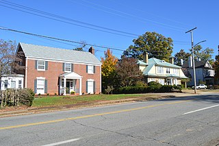
York River State Park is located near the unincorporated town of Croaker in James City County, Virginia on the south bank of the York River about 10 miles downstream from West Point.
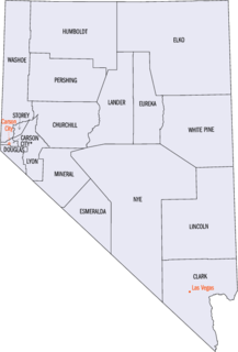
This is a list of properties and historic districts in Nevada that are listed on the National Register of Historic Places. There is at least one listing in each of Nevada's 16 counties and one independent city.

Old Point Comfort Light is a lighthouse located on the grounds of Fort Monroe in the Virginia portion of the Chesapeake Bay. It is the second oldest light in the bay and the oldest still in use. The lighthouse is owned and maintained by the U.S. Coast Guard and is listed on the National Register of Historic Places.

Holliday Lake State Park is a state park located within the confines of Appomattox-Buckingham State Forest in Virginia. The land was cleared as farmland in the 1880s before being returned to its forested state in the mid-20th century. Today, the park is known for its fishing opportunities.

This is a list of the National Register of Historic Places listings in Martinsville, Virginia.
New Martinsville Downtown Historic District is a national historic district located at New Martinsville, Wetzel County, West Virginia. It encompasses 29 contributing buildings and one contributing site that include the civic and commercial core of New Martinsville. Most of the buildings in the district are two and three story masonry commercial structures dating to the late-19th and early-20th century in popular architectural styles, such as Italianate, Romanesque Revival, and Colonial Revival. Notable buildings include the New Martinsville City Building (1895), The McCaskey Building (1898), Winer's Department Store (1908), McCrory's, The Masonic Temple (1913), Theater/Palmer's Drug Store (1911), Lincoln Theatre (1920), United States Post Office (1931), Wetzel County Sheriff's residence (1897-1901), and Wetzel County Courthouse (1902).

North Street Historic District is a national historic district located at New Martinsville, Wetzel County, West Virginia. It encompasses 23 contributing buildings that include a residential and commercial area of New Martinsville. Most of the buildings in the district date to the late-19th and early-20th century in popular architectural styles, such as Stick Style, Queen Anne, and American Foursquare. Notable buildings include the Old Hospital Building, New Martinsville Grocery Company and warehouse (1895), former Cottage Hotel (1890), and the Moose Club.
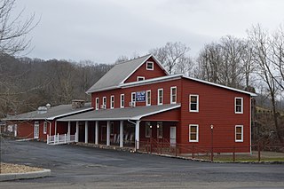
Clinch Valley Roller Mills is a historic grist mill complex located along the Clinch River at Cedar Bluff, Tazewell County, Virginia. The main building was built about 1856, and consists of a 3 1/2-story, timber frame cinder block with later 19th and early-20th century additions. There are additions for grain storage; a saw mill, now enclosed and housing the mill office; the mill dam site with its associated culvert, weirs, flume and turbines; and the 1 1/2-story shop building. The main section is believed to have been rebuilt after a fire in 1884.
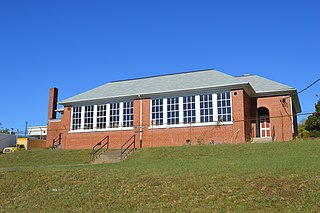
Dry Bridge Elementary School, also known as East Martinsville Grammar School, is a historic Rosenwald school located at Martinsville, Virginia. It was built between 1928 and 1930, and is a one-story, rectangular brick building with a concrete foundation, brick walls and deck-on-hip roof. The building housed four classrooms. Annexation brought Dry Bridge School into the Martinsville School District in 1948, and a freestanding school addition was built beside Dry Bridge School in 1958. The two buildings were called the East Martinsville Grammar School. The school closed at the end of the 1967-1968 school year as the result of school desegregation in Martinsville. In 1969, MARC Workshop, Inc. began occupying the building.

The Martinsville Novelty Corporation Factory is a historic factory complex located at Martinsville, Virginia. The main factory was built in 1929, and is a long, three-story, brick building that was constructed for the purpose of manufacturing small pieces of furniture called "novelty" pieces in the furniture trade. Associated with the main factory are the contributing wood storage area and the kilns where the wood was dried; a long, metal Quonset hut; a railroad spur and trestle; a long concrete-block and frame storage building; and a small, rectangular, brick building that at one time housed a restaurant that served the employees of Martinsville Novelty and W. M. Bassett Furniture factory. The Martinsville Novelty Corporation was the last significant furniture concern established in Martinsville before the Great Depression. The factory closed in 1995.

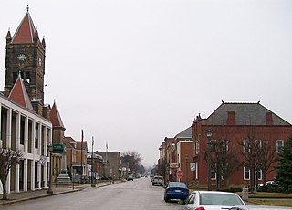
Martinsville Historic District is a national historic district located at Martinsville, Virginia. It encompasses 94 contributing buildings, 1 contributing site, and 3 contributing structures in the central business district of Martinsville. The buildings range in date from the early-19th century through the mid- 20th century and include notable examples of the Romanesque, Federal, and Colonial Revival styles. Notable buildings include the Henry County Courthouse (1824), People's Bank (1891), Globman's Department Store, Ford Building (1908), U.S. Post Office (1939), the Masonic Temple, the Henry Hotel (1921), the Martinsville Hotel, First National Bank Building (1925), the Knights of Pythias Building (1922), Oakley Apartment / Office Building (1935), the Chief Tassel Building (1930), First United Methodist Church of Martinsville (1922), Richardson's Motor Co., Gravely Pin Factory (1907), and Sale Knitting Plant (1937).

Fayette Street Historic District is a national historic district located at Martinsville, Virginia. It encompasses 116 contributing buildings, in a traditionally African-American section of Martinsville. It includes a variety of commercial, religious, educational and residential buildings dating from the late-19th century through the mid- 20th century. Notable buildings include the Dennis Hairston House, community Market (1925), Mt. Carmel Church, Grace United Presbyterian Church, Albert Harris Intermediate School, Alex Hairston House, Baldwin Block, Watkins-Hairston Funeral Home (1931), Gordon Building (1941), and the Imperial Savings and Loan (1953).
East Church Street–Starling Avenue Historic District is a national historic district located at Martinsville, Virginia. It encompasses 117 contributing buildings, 1 contributing structure, and 1 contributing object in a residential section of Martinsville. The buildings range in date from the range in date from the mid 1880s to the mid-1950s and include notable examples of the Tudor Revival and Colonial Revival styles. Notable buildings include the James Cheshire House, the Obidiah Allen House, John W. Carter House (1896), Christ Episcopal Church (1890s), G.T. Lester House or the “Wedding Cake House” (1918), John W. Townes House, Vaughn M. Draper House, and Martinsville High School (1940) and Gymnasium Building (1928). Located in the district are the separately listed John Waddey Carter House, Scuffle Hill, and the Little Post Office.
McCollum Fish Weir is a historic Native American fish weir located near Lockhart, Chester County, South Carolina. The site consists of a V-shaped fish trap or weir located on the Broad River approximately 500–600 feet upstream from the McCollum Mound, from which it gets its name.

Nation Ford Fish Weir is a historic fishing weir located near Rock Hill, South Carolina. It is one of the few relatively intact Native American fish weirs remaining in South Carolina. It is a double "V"-shaped rock fish trap or weir located in the channel of the Catawba River upstream from the railroad trestle at Nation Ford. The weir is located near the Nation Ford Road crossing point of the river and to several documented Catawba people villages.
Indian Fish Trap State Preserve, also known as the Indian Fish Weir, is a historic site located near the Amana Colonies in rural Iowa County, Iowa. The fish weir is an array of rocks in a V-shaped formation in the Iowa River. It is the only structure of this kind in Iowa. It is not known when the fish weir was built, possibly in either the Late Prehistoric period or Early Historic period. Glacial boulders from a nearby bluff were probably used to construct it. Each wing of the dam is about 155 feet (47 m) in length. The fish were thought to be herded toward the vertex of the "V" where they would be easier to net or spear. They were then placed into an adjacent holding pool. Early pioneers discovered the weir, and it was included on a General Land Office map in the 1840s. Archaeologist Charles R. Keyes wrote about the weir in 1925.

The Martinsville Road Covered Bridge, west of Martinsville, Ohio in Clark Township, Clinton County, Ohio, was built in 1871. It was listed on the National Register of Historic Places in 1974.


