Stonington Island is a rocky island lying 1.8 km (1.1 mi) northeast of Neny Island in the eastern part of Marguerite Bay off the west coast of Graham Land, Antarctica. It is 0.75 km (0.47 mi) long from north-west to south-east and 0.37 km (0.23 mi) wide, yielding an area of 20 ha. It was formerly connected by a drifted snow slope to Northeast Glacier on the mainland. Highest elevation is Anemometer Hill which rises to 25 m (82 ft).
The Ch'ŏngch'ŏn is a river of North Korea having its source in the Rangrim Mountains of Chagang Province and emptying into the Yellow Sea at Sinanju. The river flows past Myohyang-san and through the city of Anju, South P'yŏngan Province. Its total length is 217 km (135 mi), and it drains a basin of 9,553 km2.

Unmu-do is an 80 ha island in the north-eastern Yellow Sea lying about 19 km off the western coast of North Korea. The site has been identified by BirdLife International as an Important Bird Area (IBA) because it supports endangered black-faced spoonbills.
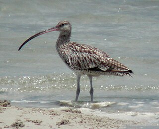
The Sogam-do, Daegam-do, Zung-do, Ae-do and Hyengzedo Islands Important Bird Area comprises a group of small islands, with a collective area of 18 ha, in the north-eastern Yellow Sea, lying close to the western coast of North Korea. The site has been identified by BirdLife International as an Important Bird Area (IBA) because it supports breeding endangered black-faced spoonbills as well as vulnerable Chinese egrets and up to 850 Far Eastern curlews as passage migrants. The site has been designated one of North Korea’s Natural Monuments.

The Daedong Bay Important Bird Area lies on the north-eastern coast of the Yellow Sea on the west coast of North Korea near the mouth of the Taedong River. It comprises 3,500 ha of marine, intertidal and beach wetlands, encompassing a 2,000 ha protected area. It has been identified by BirdLife International as an Important Bird Area (IBA) because it supports significant populations of various birds, including greater white-fronted geese, Oriental storks, black-faced spoonbills, Chinese egrets, great bustards, hooded cranes, red-crowned cranes, Far Eastern curlews, Nordmann's greenshanks and spoon-billed sandpipers. Threats to the site include agricultural intensification and aquacultural development.

The Ongjin Bay Important Bird Area lies on the western coast of North Korea on the Yellow Sea, in Ongjin County, South Hwanghae. It comprises 3500 ha of wetlands, including rice paddies, and encompasses a 1000 ha protected area. It has been identified by BirdLife International as an Important Bird Area (IBA) because it supports significant populations of various birds, including swan geese, bean geese, greater white-fronted geese, Oriental storks, black-faced spoonbills, white-naped cranes, red-crowned cranes, long-billed plovers and Far Eastern curlews. It is threatened by aquacultural development.

Ŭllyul Kŭmsanp'o is an 800 ha wetland wildlife reserve on the north-eastern shore of the Yellow Sea, on the west coast of North Korea in Ŭllyul County, South Hwanghae Province south of the estuary of the Taedong River. The site forms the core of a 1400 ha Important Bird Area (IBA), identified as such by BirdLife International because, with adjacent rice paddies, it supports populations of migrating and wintering water and wetland birds. Species using the site include swan geese, whooper swans, black-faced spoonbills, Chinese egrets, red-crowned cranes and Nordmann's greenshanks. The IBA is threatened by agricultural intensification.

Kangryong Field is a 1200 ha wetland site in South Hwanghae Province of North Korea. It has been identified by BirdLife International as an Important Bird Area (IBA) because it supports populations of Oriental storks, black-faced spoonbills, Chinese egrets, red-crowned cranes and spoon-billed sandpipers.

Onchon Field is a 50,000 ha wetland site in South Pyongan Province of North Korea. It contains freshwater wetlands, rice paddies and salt pans. It has been identified by BirdLife International as an Important Bird Area (IBA) because it supports populations of swan geese, greater white-fronted geese, whooper swans, black-faced spoonbills, Chinese egrets, great bustards, white-naped cranes, hooded cranes and red-crowned cranes. It is threatened by agricultural intensification, aquacultural development and human disturbance.

The Taedong River estuary Important Bird Area is an 11,500 ha site in southern South Pyongan Province of North Korea, where the Taedong River meets the Yellow Sea. It has been identified by BirdLife International as an Important Bird Area (IBA) because it supports populations of various waterbirds. These include swan geese, mute swans, whooper swans, Baikal teals, Steller's sea-eagles, red-crowned cranes and Saunders's gulls. The site comprises a range of wetlands including freshwater lakes, salt pans and rice paddies. Threats to the IBA include agricultural intensification and aquacultural development.

Areia Branca beach and hinterland is a 2994 ha Important Bird Area (IBA) in East Timor, a country occupying the eastern end of the island of Timor at the eastern end of the Lesser Sunda Islands group of Wallacea.

Lake Be Malae, also spelt Bemalae, is a 3000 ha lagoon in the district of Bobonaro on the north-west coast of East Timor, a country occupying the eastern end of the island of Timor in the Lesser Sunda Islands of Wallacea.
The Irebere estuary and Iliomar forest Important Bird Area is a tract of land in East Timor, a country occupying the eastern end of the island of Timor in the Lesser Sunda Islands of Wallacea.

The Loré Important Bird Area is a 10,906 ha tract of land in East Timor, a country occupying the eastern end of the island of Timor in the Lesser Sunda Islands of Wallacea. It forms the south-westernmost part of the Nino Konis Santana National Park.

The Mount Curi Important Bird Area is a 200 km2 tract of land in East Timor, a country occupying the eastern end of the island of Timor in the Lesser Sunda Islands of Wallacea.

The Mount Mak Fahik and Mount Sarim Important Bird Area is a tract of mountainous land in East Timor, a country occupying the eastern end of the island of Timor in the Lesser Sunda Islands of Wallacea.

The Sungai Clere Important Bird Area, also known as the Sungai Clere Protected Wildlife Area, and in Indonesian as Hutan Metiboat, is a tract of low-lying forest and grassland in East Timor, a country occupying the eastern end of the island of Timor in the Lesser Sunda Islands of Wallacea.

The Tilomar Important Bird Area, also known as Tilomar Forest, is a tract of mainly forested land in East Timor, a country occupying the eastern end of the island of Timor in the Lesser Sunda Islands of Wallacea.
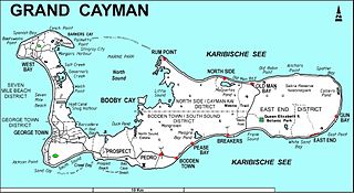
The Botanic Park and Salina Reserve Important Bird Area comprises two separate sites on Grand Cayman, one of the Cayman Islands, a British Overseas Territory in the Caribbean Sea.