
Sevier County ( "severe") is a county of the U.S. state of Tennessee. As of the 2010 census, the population was 89,889. Its county seat and largest city is Sevierville.

Campbell County is a county located in the U.S. state of Tennessee. As of the 2010 census, the population was 40,716. Its county seat is Jacksboro.

Chickamauga is a city in Walker County, Georgia, United States. The population was 2,245 at the 2000 census and 3,101 in 2010. It is part of the Chattanooga, TN–GA Metropolitan Statistical Area.

Walker Basin is an isolated unincorporated community and valley in the Southern Sierra Nevada, in Kern County, California.
Morrisons Cove, is an eroded anticlinal valley in Blair and Bedford counties of central Pennsylvania, United States, extending from Evitts Mountain near New Enterprise, north to the Frankstown Branch Juniata River at Williamsburg. The width of the valley varies from 10 to 15 miles between Tussey Mountain on the east to the chain of Dunning, Loop and Lock Mountains on the west. Almost entirely enclosed by these mountains, the only openings in the cove are at Loysburg Gap in the south, McKee Gap in the west, and at Williamsburg to the north. The floor of the valley is mostly level, with many large fertile farm fields. The southern end of the valley drains to the Raystown Branch Juniata River via Yellow Creek through Loysburg Gap, and the northern end drains to the Frankstown Branch, via Clover Creek.

Cove Lake State Park is a state park in Campbell County, Tennessee, in the southeastern United States. The park consists of 673 acres (2.72 km2) situated around Cove Lake, an impoundment of Cove Creek created by the completion of Caryville Dam in 1936. The park's location is adjacent to the town of Caryville and just west of Jacksboro.

Wears Valley is an unincorporated community in Sevier County, Tennessee, treated by the U.S. Census Bureau as a census county division. As of the 2000 Census, the population of Wears Valley was 6,486.

The Calfpasture River is a river in the U.S. state of Virginia. It flows about 41.0 miles (66.0 km) from its source, Gordons Peak in the Allegheny Mountains, to its confluence with the Little Calfpasture River, forming the Maury River. Via the Maury, the Calfpasture's waters flow into the James River, thence Chesapeake Bay and the Atlantic Ocean.

Little Greenbrier is the name of a former Appalachian community that is now an historical area in the Great Smoky Mountains of East Tennessee. The community was situated in a hollow rising from Metcalf Bottoms along Little River to the upper slopes of Cove Mountain, in the northeastern section of the national park. Little Greenbrier was once known simply as "Greenbrier," but the "Little" was added to its name to distinguish it from the larger Greenbrier located between Mount Le Conte and Mount Guyot to the east.

Walland is an unincorporated community and census-designated place (CDP) in Blount County, Tennessee, in the Southeastern United States. Its population was 259 as of the 2010 census. Walland is the site of a post office and is the place name associated with zip code 37886, which covers an area beyond the Walland community.

U.S. Route 522 is a part of the U.S. Highway System that runs from Powhatan, Virginia to Selinsgrove, Pennsylvania. In Pennsylvania, the U.S. highway runs 127.5 miles (205.2 km) from the Maryland state line near Warfordsburg north to its northern terminus at US 11 and US 15 in Selinsgrove. US 522 passes through the Ridge and Valley Province of the Appalachian Mountains of central Pennsylvania, connecting Hancock, Maryland on the Potomac River with McConnellsburg, Mount Union, Lewistown, Middleburg, and Selinsgrove on the Susquehanna River. The U.S. highway is part of the National Highway System along its concurrency with Interstate 70 (I-70) from the Maryland state line to Warfordsburg and from US 522's interchange with the Pennsylvania Turnpike (I-76) to Selinsgrove.

Wear Cove is a valley in southwestern Sevier County, Tennessee. It runs parallel to the Great Smoky Mountains National Park just to its south. Like other park border regions, the history and economy of the valley are intertwined with that of the Smokies. The primary community is Wears Valley.
Kensington is an unincorporated community in Walker County, Georgia, United States, northwest of LaFayette.
McLemore is a Scottish surname, possibly derived from an anglicisation of the Gaelic name Mac Gille Mhoire, the same origin as the name Gilmour. Notable people with this surname include:
The Walker Sisters Place was a homestead in the Great Smoky Mountains of Sevier County, in the U.S. state of Tennessee. The surviving structures— which include the cabin, springhouse, and corn crib— were once part of a farm that belonged to the Walker Sisters— five spinster sisters who became local legends due to their adherence to traditional ways of living. The sisters inherited the farm from their father, and after the Great Smoky Mountains National Park was formed in the 1930s, they obtained a lifetime lease. The National Park Service gained control of the property in 1964 when the last Walker sister died. The surviving structures were placed on the National Register of Historic Places in 1976.

The Lost River is a 31.1-mile-long (50.1 km) river in the Appalachian Mountains of Hardy County in West Virginia's Eastern Panhandle region. The Lost River is geologically the same river as the Cacapon River: It flows into an underground channel northeast of McCauley along West Virginia Route 259 at "the Sinks" and reappears near Wardensville as the Cacapon. The source of the Lost River lies south of Mathias near the West Virginia/Virginia border. Along with the Cacapon and North rivers, the Lost River serves as one of the three main segments of the Cacapon River and its watershed.

Fort Loudon (CDP) is an unincorporated community and census-designated place (CDP) in Peters Township, Franklin County, Pennsylvania, United States. As of the 2010 census the population was 886.

Pigeon Mountain is a summit in Walker County, Georgia. At its highest point, the mountain has an elevation of around 2,330 feet (710 m). Ellison's Cave and Petty John's Cave are located on the mountain. Most of the mountain is located inside the Crockford-Pigeon Mountain Wildlife Management Area.
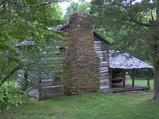
The McLemore Cove Historic District near Kensington, Georgia, about 3 miles (4.8 km) south of Chickamauga, Georgia, is a 50,141-acre (20,291 ha) historic district listed on the National Register of Historic Places. It includes 262 contributing buildings, 15 other contributing structures, 15 contributing sites, and a contributing object, as well as 327 non-contributing buildings and structures. It consists of the roughly triangular-shaped valley, McLemore Cove, between the ridge lines of Lookout Mountain on the west and Pigeon Mountain on the east.


