
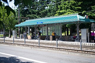
Rockwood/East 188th Avenue is a MAX light rail station in Gresham, Oregon. It serves the Blue Line and is the 21st stop eastbound on the eastside MAX branch. The station is at the intersection of Southeast 188th Avenue and Burnside Street, within the Rockwood neighborhood. This station is a hub for bus service to Gateway Transit Center and Gresham Transit Center.

East 181st Avenue station is a MAX light rail station in Gresham, Oregon. It serves the Blue Line and is the 20th stop eastbound on the eastside MAX line.
East 162nd Avenue station is a MAX light rail station on the boundary between Portland and Gresham in Oregon, USA. It serves the Blue Line and is the 18th stop eastbound on the current Eastside MAX branch.

East 102nd Avenue station is a MAX light rail station in Portland, Oregon. It serves the Blue Line and is the 15th stop eastbound on the current Eastside MAX branch.

Northeast 60th Avenue is a light rail station on the MAX Blue, Green and Red Lines in Portland, Oregon. It is the 12th stop eastbound on the eastside MAX line. It is located on the boundary between the North Tabor and Rose City Park neighborhoods.

The Northeast 82nd Avenue station is a light rail station on the MAX Blue, Green and Red Lines in Portland, Oregon. It is the 13th stop eastbound on the eastside MAX. It serves the neighborhoods of Rose City Park, Roseway, Madison South, Montavilla and Mount Tabor.

Lloyd Center/Northeast 11th Avenue is a light rail station on the MAX Blue, Green and Red Lines in Portland, Oregon. It is the 10th stop eastbound on the Eastside MAX. The station is located on the 1200 block of Northeast Holladay Street in Lloyd District.
Northeast 7th Avenue is a light rail station on the Blue, Green and Red Lines in Portland, Oregon. It is the 9th stop eastbound on the Eastside MAX.

Convention Center station is a light rail station on the MAX Blue, Green and Red Lines in Portland, Oregon. It is the 8th stop eastbound on the current Eastside MAX, having not been built when the original line opened, in 1986. It was built to serve the Oregon Convention Center, which did not exist when the MAX line opened, and was completed and opened in the same month as the Convention Center, September 1990.

Old Town/Chinatown station is a MAX Light Rail station served by the Blue and Red Lines. It is located in the Old Town Chinatown neighborhood in Portland, Oregon and is currently the 6th stop eastbound on the Eastside MAX. It is also the last stop before crossing the Willamette River. It is next to the Portland Downtown Heliport. The station was previously also served by the Yellow Line, from 2004 to 2009, until that line's relocation to the Portland Transit Mall.
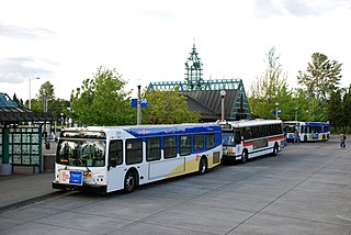
Beaverton Transit Center is a multimodal transport hub in Beaverton, Oregon, United States. Owned and operated by TriMet, it is served by bus, commuter rail, and light rail. The transit center is MAX Light Rail's 15th station eastbound on the Blue Line and western terminus on the Red Line. It is also the northern terminus of WES Commuter Rail and a hub for bus routes mostly serving the westside communities of the Portland metropolitan area. Beaverton Transit Center is situated on Southwest Lombard Avenue, just north of Southwest Canyon Road in central Beaverton, connected by walkway to Canyon Place Shopping Center. It recorded 9,709 average weekday boardings for all modes in fall 2018, making it TriMet's busiest transit center.

Hillsboro Central/Southeast 3rd Avenue Transit Center, also known as Hillsboro Transit Center, is a light rail station and transit center on the MAX Blue Line in Hillsboro, Oregon. Opened in 1998, the red-brick station is the 19th stop westbound on the Westside MAX, one stop from the western terminus of the line. Physically the largest station on the line, it is located at a former stop of the Oregon Electric Railway and includes artwork honoring the history of the community.

Tuality Hospital/Southeast 8th Avenue is a light rail station on the MAX Blue Line in Hillsboro, Oregon, United States. Opened in 1998, it is the 18th stop westbound on the Westside MAX. The station has a single island platform with a passenger shelter, with the station primarily serving the campus of Hillsboro Medical Center.
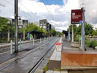
Beaverton Central is a light rail station on the MAX Blue Line in Beaverton, Oregon, United States.

Beaverton Creek is a light rail station on the MAX Blue Line in Beaverton, Oregon, United States. It is the 9th stop westbound on the Westside MAX.

Elmonica/Southwest 170th Avenue is a light rail station on the MAX Blue Line in Beaverton, Oregon, United States. Named after a former station on the Oregon Electric Railway, it is the eleventh stop westbound on the Westside MAX. The side platform stop is located between Hillsboro to the west and Beaverton to the east.

Washington/Southeast 12th Avenue is a light rail station on the MAX Blue Line in Hillsboro, Oregon. Hillsboro's West Precinct is near the station. Opened in 1998, it is the 17th stop westbound on the Westside MAX, and the last eastbound stop prior to crossing the Main Street Bridge. This is the last stop westbound to be on a grade-separated right-of-way. One block west of here, trains enter the median of Washington Avenue to run through downtown Hillsboro.

Fair Complex/Hillsboro Airport is a light rail station on the MAX Blue Line in Hillsboro, Oregon, United States. It is the 16th stop westbound on the Westside MAX, and the last westbound stop prior to crossing the Main Street Bridge. The station is located close to the Westside Commons – the 2019-adopted new name for the Washington County Fair Complex – and Hillsboro Airport, a major general-aviation facility in Hillsboro, and the location of the Oregon International Airshow in the summer. Bus line 46-North Hillsboro serves the station.

Quatama, formerly Quatama/Northwest 205th Avenue, is a light rail station in Hillsboro, Oregon, United States, that is served by TriMet as part of the MAX Light Rail system. Situated between Orenco station and Willow Creek/Southwest 185th Avenue Transit Center, it is the seventh eastbound station on the Blue Line. The two-track, island platform station includes a park-and-ride lot. Quatama Station is named after the area which includes Quatama Road to the south of the station. Opened in 1998, the stop is near high-tech industries and the Amberglen business park, which includes Oregon Health & Science University's West Campus and the Oregon National Primate Research Center. With the renaming of Northwest 205th Avenue to Northeast John Olsen Avenue by the city of Hillsboro in 2017, TriMet changed the station's name from its original, longer name.

Hawthorn Farm is a light rail station on the MAX Blue Line in Hillsboro, Oregon, United States. Opened in 1998, it is the 15th stop westbound on the Westside MAX. The TriMet owned station does not have a parking lot nor bus connections. Artwork at the station utilizes electronics to provide waiting passengers with indicators of approaching trains, the wind's direction, and sounds from a neighboring wetlands area. The name of the station comes from the name of the family who once owned a farm and a historic home on the land, and is shared with a business park and an Intel campus.

