
Ashburton is a large town in the Canterbury Region, on the east coast of the South Island of New Zealand. The town is the seat of the Ashburton District. It is 85 kilometres (53 mi) south west of Christchurch and is sometimes regarded as a satellite town of Christchurch.

Mount Hutt rises to the west of the Canterbury Plains in the South Island of New Zealand, above the braided upper reaches of the Rakaia River, and 80 kilometres west of Christchurch. Its summit is 2190 metres above sea level.

The Canterbury Plains are an area in New Zealand centred in the Mid Canterbury, to the south of the city of Christchurch in the Canterbury region. Their northern extremes are at the foot of the Hundalee Hills in the Hurunui District, and in the south they merge into the plains of North Otago beyond the Waitaki River. The smaller Amuri Plain forms a northern extension of the plains.

The Waimakariri River is one of the largest rivers in Canterbury, on the eastern coast of New Zealand's South Island. It flows for 151 kilometres (94 mi) in a generally southeastward direction from the Southern Alps across the Canterbury Plains to the Pacific Ocean.

The Rangitata River is one of the braided rivers of the Canterbury Plains in southern New Zealand. It flows southeast for 120 kilometres (75 mi) from the Southern Alps, entering the Pacific Ocean 30 kilometres (19 mi) northeast of Timaru. The river has a catchment area of 1,773 square kilometres (685 sq mi), and a mean annual flow of 95 cubic metres per second (3,400 cu ft/s) at Klondyke.

The Rakaia Gorge is located on the Rakaia River in inland Canterbury in New Zealand's South Island.
Ashburton was a New Zealand electorate, first created in 1881 and centred on the South Island town of Ashburton.

South Canterbury is the area of the Canterbury Region of the South Island of New Zealand bounded by the Rangitata River in the north and the Waitaki River to the south. The Pacific Ocean and ridge of the Southern Alps form natural boundaries to the east and west respectively. Though the exact boundaries of the region have never been formalised, the term is used for a variety of government agencies and other entities. It is one of four traditional sub-regions of Canterbury, along with Mid Canterbury, North Canterbury, and Christchurch city.

Canterbury in New Zealand is the portion of the South Island to the east of the Southern Alps / Kā Tiritiri o te Moana, from the Waiau Uwha River in the north, to the Waitaki River in the south.
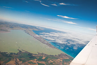
The Canterbury Bight is a large bight on the eastern side of New Zealand's South Island. The bight runs for approximately 135 kilometres (84 mi) from the southern end of Banks Peninsula to the settlement of Timaru and faces southeast, exposing it to high-energy storm waves originating in the Pacific Ocean. The bight is known for rough conditions as a result, with wave heights of over 2 metres (6.6 ft) common. Much of the bight's geography is shaped by this high-energy environment interacting with multiple large rivers which enter the Pacific in the bight, such as the Rakaia, Ashburton / Hakatere, and Rangitata Rivers. Sediment from these rivers, predominantly Greywacke, is deposited along the coast and extends up to 50 kilometres (31 mi) out to sea from the current shoreline. Multiple hapua, or river-mouth lagoons, can be found along the length of the bight where waves have deposited sufficient sediment to form a barrier across a river mouth, including most notably Lake Ellesmere / Te Waihora and Washdyke Lagoon
State Highway 77 is a state highway in New Zealand going through the inland parts of Central and Mid Canterbury between the towns of Ashburton and Darfield via the Rakaia Gorge. It is wholly single carriageway with two one-lane bridges at the Rakaia and Selwyn Rivers. One set of traffic lights is found in Ashburton marking the southern terminus of the highway.

Ashburton District is a territorial authority district in the Canterbury Region of the South Island of New Zealand. It encompasses the town of Ashburton, a number of small towns and settlements and the surrounding rural area, roughly coterminous with Mid Canterbury. The district had a population of 36,800 as of June 2023.
The Ashburton River / Hakatere is a river in the Canterbury region of New Zealand, flowing across Mid Canterbury from the Southern Alps to the Pacific Ocean. The official name of the river was amended to become a dual name by the Ngāi Tahu Claims Settlement Act 1998. It has been identified as an Important Bird Area by BirdLife International because it supports breeding colonies of the endangered black-billed gull.

The Arrowsmith Range is a mountain range in the South Island of New Zealand. The range runs from southwest to northeast, parallel to the main ranges of the Southern Alps / Kā Tiritiri o te Moana. At the northeastern end, the range terminates at Jagged Peak, whence a ridge connects to the Jollie Range. The lower Potts Range is a continuation at the southwestern end of the range. The highest point on the range is Mount Arrowsmith.

Lake Clearwater is in the Ashburton District of the South Island of New Zealand. The outlet feeds into the south branch of the Ashburton River / Hakatere. Located in the upper reaches of the Rangitata River a small village of holiday homes, also called Lake Clearwater, is located between Lake Clearwater and the smaller neighbour Lake Camp.

Electricity Ashburton Limited, trading as EA Networks is a co-operatively-owned electricity distribution company, based in Ashburton, New Zealand.

The RangitataGorge is a gorge located in the Canterbury High Country in the South Island of New Zealand. The narrow gorge links the headwaters of the Rangitata River with the fertile Canterbury Plains. The Rangitata gorge is commercially rafted by a local company. It is also a popular river for visiting kayakers, fishermen and adventurist locals in jet boats. The gorge is a class IV to V+ depending on the flow of the river and home to the notable rapids including Rooster's Tail, Pencil Sharpener, The Pinch, Pigs Trough and Hells Gate.

Hakatere Conservation Park is a protected area between the Rakaia River and the Rangitata River in the Ashburton District of New Zealand. The park was established in 2007. It covers 60,000 hectares of rugged mountains and mountain basins, tussocklands and beech forest. It includes the Ashburton Lakes, such as Lake Heron and Lake Clearwater, popular tramping area Mount Somers / Te Kiekie, and Mount Hutt skifield. The closest town is Mount Somers.

The Rangitata Diversion Race or RDR is a combined irrigation and power generation scheme that diverts water from the Rangitata River to irrigate over 66,000 hectares of farmland in Mid-Canterbury, New Zealand. The RDR project was the first major river diversion in New Zealand, and the largest irrigation scheme in the country. It was originally constructed by the Public Works Department between 1937 and 1944. The main canal is 67 km long, 10 m wide and 3 m deep.

The Two Thumb Range is a range of mountains in the Canterbury Region of New Zealand's South Island. It is located to the east of Lake Tekapo and has several peaks which rise to around 2,500 metres (8,200 ft). The southern end of the range contains one of Canterbury's main skifields, Mount Dobson.
