
East Sussex is a county in South East England on the English Channel coast. It is bordered by the counties of Kent to the north and east, West Sussex to the west, and Surrey for a short distance to the north-west.
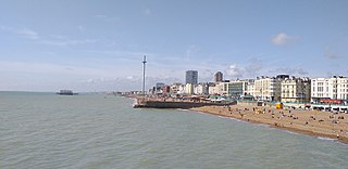
Brighton and Hove is a city and unitary authority in East Sussex, England. It consists primarily of the settlements of Brighton and Hove, alongside neighbouring villages.

West Sussex is a county in South East England on the English Channel coast. The ceremonial county comprises the shire districts of Adur, Arun, Chichester, Horsham, and Mid Sussex, and the boroughs of Crawley and Worthing. Covering an area of 1,991 square kilometres, West Sussex borders Hampshire to the west, Surrey to the north, and East Sussex to the east. The county town and only city in West Sussex is Chichester, located in the south-west of the county. This was legally formalised with the establishment of West Sussex Council in 1888 but within the ceremonial Sussex. After the reorganisation of local government in 1974, the ceremonial function of the historic county of Sussex was divided into two separate counties, West Sussex and East Sussex. The existing East and West Sussex councils took control respectively, with Mid Sussex and parts of Crawley being transferred to the West Sussex administration from East Sussex. In the 2011 census, West Sussex recorded a population of 806,900.

Burgess Hill is a town and civil parish in West Sussex, England, close to the border with East Sussex, on the edge of the South Downs National Park 39 mi (63 km) south of London, 10 mi (16 km) north of Brighton and Hove, and 29 mi (47 km) northeast of the county town, Chichester. It had an area of 3.7 sq mi (9.6 km2) and a population of 30,635 at the 2011 Census, making it the fourth most populous parish in the county and the most populous in the Mid Sussex District. Other nearby towns include Haywards Heath to the northeast and Lewes, the county town of East Sussex, to the southeast.

Crawley is a large town and borough in West Sussex, England. It is 28 miles (45 km) south of London, 18 miles (29 km) north of Brighton and Hove, and 32 miles (51 km) north-east of the county town of Chichester. Crawley covers an area of 17.36 square miles (44.96 km2) and had a population of 106,597 at the time of the 2011 Census.
Mid Sussex is a local government district in the English non-metropolitan county of West Sussex, within the historic county of Sussex. It contains the towns of East Grinstead, Haywards Heath and Burgess Hill.

Worthing is a seaside town in West Sussex, England, at the foot of the South Downs, 10 miles (16 km) west of Brighton, and 18 miles (29 km) east of Chichester. With a population of about 110,000 and an area of 12.5 square miles (32.4 km2), the borough is the second largest component of the Brighton and Hove built-up area, the 15th most populous urban area in the United Kingdom. Since 2010, northern parts of the borough, including the Worthing Downland Estate, have formed part of the South Downs National Park. In 2019, the Art Deco Worthing Pier was named the best in Britain.

Tandridge is a local government district in east Surrey, England. Its council is based in Oxted, although the largest settlement is Caterham; other notable settlements include Warlingham, Godstone and Lingfield. In mid-2019, the district had an estimated population of 88,129.

Rother is a local government district in East Sussex, England. Its council is based in Bexhill-on-Sea. The district is named after the River Rother which flows within its boundaries.

Horsham is a local government district in West Sussex, England. Its council is based in Horsham. The district borders those of Crawley, Mid Sussex, Mole Valley, Chichester, Arun and Adur, and the unitary authority of Brighton & Hove.

Mid Sussex is a constituency represented in the House of Commons of the UK Parliament from 2019 by Mims Davies, a Conservative. She is currently a minister in the Department for Work and Pensions.

Ashurst Wood is a village and civil parish in the Mid Sussex District of West Sussex, within the historic county of Sussex, England. It is 1 mile (2 km) to the southeast of East Grinstead, just off the A22 arterial road. In 2001, the population was 1,771, increasing to 1,833 at the 2011 Census. Ashurst Wood is within the High Weald Area of Natural Beauty and has an SSSI inside its boundaries. The village has a history of agriculture and farming, and contains a church, village hall, primary school, two public houses, a general shop, post office and several small business premises. There is an independent school on the boundary of the village, called Brambletye School, and a former one, Stoke Brunswick School, which closed in 2009. Bus routes run through the village with destinations of East Grinstead, Crawley, Haywards Heath, Tunbridge Wells and Brighton.

Sussex Police is the territorial police force responsible for policing in the whole of Sussex. Its jurisdiction covers the ceremonial counties of East Sussex and West Sussex. The force is headquartered in Malling House, Lewes, East Sussex.

The Worth Way is a 7-mile (11 km) footpath and bridleway linking the West Sussex towns of Crawley and East Grinstead via the village of Crawley Down. Mostly following the trackbed of a disused railway the path is an important wildlife corridor. It is part of the National Cycle Network.
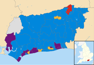
The West Sussex County Council election, 2013 took place on 2 May 2013, as part of the 2013 United Kingdom local elections. All 71 electoral divisions were up for election, which returned one county councillor each by first-past-the-post voting for a four-year term of office. At this election, the Conservative Party was seeking to retain overall control of the council, and the Liberal Democrats to maintain their position as the main opposition party.
The history of local government in Sussex is unique and complex. Founded as a kingdom in the 5th century, Sussex was annexed by the kingdom of Wessex in the 9th century, which after further developments became the Kingdom of England. It currently corresponds to two counties, East Sussex and West Sussex.

The 2017 West Sussex County Council election took place as part of the 2017 local elections in the UK. All councillors were elected for single-member electoral divisions for a four-year term. The voting system used was first-past-the-post.