
Cape Breton Island is an island on the Atlantic coast of North America and part of the province of Nova Scotia, Canada.

The Maritimes, also called the Maritime provinces, is a region of Eastern Canada consisting of three provinces: New Brunswick, Nova Scotia, and Prince Edward Island. The Maritimes had a population of 1,899,324 in 2021, which makes up 5.1% of Canada's population. Together with Canada's easternmost province, Newfoundland and Labrador, the Maritime provinces make up the region of Atlantic Canada.

The Fortress of Louisbourg is a National Historic Site and the location of a one-quarter partial reconstruction of an 18th-century French fortress at Louisbourg on Cape Breton Island, Nova Scotia. Its two sieges, especially that of 1758, were turning points in the Anglo-French struggle for what today is Canada.

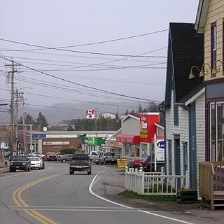
Louisbourg is an unincorporated community and former town in Cape Breton Regional Municipality, Nova Scotia.

Cape Breton Regional Municipality is the Canadian province of Nova Scotia's second largest municipality and the economic heart of Cape Breton Island. As of 2016 the municipality has a population of 94,285. The municipality was created in 1995 through the amalgamation of eight municipalities located in Cape Breton County.
Glace Bay is a community in the eastern part of the Cape Breton Regional Municipality in Nova Scotia, Canada. It forms part of the general area referred to as Industrial Cape Breton.

The Sydney and Louisburg Railway (S&L) was a Canadian railway. Built to transport coal from various mines to the ports of Sydney and Louisbourg, the S&L operated in the eastern part of Cape Breton County, Nova Scotia. The railway uses a slightly different spelling for the town of "Louisbourg".
St. Peter's is a small incorporated village located on Cape Breton Island in Richmond County, Nova Scotia, Canada.
Cape Breton Nova is a former provincial electoral district in Nova Scotia, Canada which existed between 1956 and 2013. It elected one member to the Nova Scotia House of Assembly. In its last configuration, the district included the northern parts of Sydney including Whitney Pier, as well as a small area of Cape Breton County, all within the Cape Breton Regional Municipality.
The Marconi Trail is a scenic roadway in the Canadian province of Nova Scotia.
Albert Bridge is a Canadian rural community in Nova Scotia's Cape Breton Regional Municipality.
Donkin is a Canadian rural village with a population of 532 as of 2021. Located on the picturesque coastline of Nova Scotia's Cape Breton Island, it is a part of the Cape Breton Regional Municipality. The smaller communities of Port Caledonia and Schooner Pond are directly adjacent to the village proper, connected by a single strip of road called the Donkin Highway.
Catalone is a community in the Canadian province of Nova Scotia, located in the Cape Breton Regional Municipality on Cape Breton Island.
Coxheath is a community in the Canadian province of Nova Scotia, located north of the Sydney River in the Cape Breton Regional Municipality on Cape Breton Island. The community is home to Riverview Rural High School, a secondary school with approximately 900 students in Grades 10-12 and Coxheath Elementary.
Catalone Gut is a community in the Canadian province of Nova Scotia, located in the Cape Breton Regional Municipality on Cape Breton Island. It is named after Gédéon de Catalogne, a French officer, who was a cartographer stationed at the Fortress of Louisbourg.
Scatarie Island is an island in the Canadian province of Nova Scotia, located off the coast of Baleine, Cape Breton Island.

Cape Breton East is a provincial electoral district in Nova Scotia, Canada, that elects one member of the Nova Scotia House of Assembly. The riding is represented by Brian Comer of the Progressive Conservative Party.
Sydney-Membertou is a provincial electoral district in Nova Scotia, Canada, that elects one member of the Nova Scotia House of Assembly. It was created in 2012 as Sydney-Whtiney Pier from 79% of Cape Breton Nova and 59% of Cape Breton South. Following the 2019 redistribution, the riding lost Whitney Pier to Cape Breton Centre-Whitney Pier, while gaining some territory from Sydney River-Mira-Louisbourg, and was re-named Sydney-Membertou.
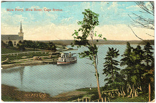
Mira River Provincial Park is a provincial park situated on the Mira River in Cape Breton County, Nova Scotia, 22 kilometres (14 mi) from Sydney and 17 kilometres (11 mi) from the Fortress of Louisbourg National Historic Site of Canada. Opened in 1967, the 87.49 hectares property offers camping sites and a range of opportunities for outdoor recreation, including picnicking, swimming, canoeing, kayaking, biking, front-country hiking, boating, fishing, cross-country skiing, snowshoeing, and geocaching.

The Louisbourg Lighthouse Trail is a hiking trail on Cape Breton Island in the Canadian province of Nova Scotia. The trailhead is located on Lighthouse Point, at the Louisbourg Lighthouse, within the Fortress of Louisbourg National Historic Site. The Louisbourg Lighthouse is the site of Canada’s first lighthouse which was built here in 1734.

