Olympus Mons is a very large shield volcano on the planet Mars. The volcano has a height of nearly 22 km as measured by the Mars Orbiter Laser Altimeter (MOLA). Olympus Mons is about two and a half times Mount Everest's height above sea level. It is the largest volcano, the tallest planetary mountain, and the second tallest mountain currently discovered in the Solar System compared to Rheasilvia on Vesta. It is the youngest of the large volcanoes on Mars, having formed during Mars's Hesperian Period. It had been known to astronomers since the late 19th century as the albedo feature Nix Olympica. Its mountainous nature was suspected well before space probes confirmed its identity as a mountain.

Ascraeus Mons is a large shield volcano located in the Tharsis region of the planet Mars. It is the northernmost and tallest of three shield volcanoes collectively known as the Tharsis Montes.

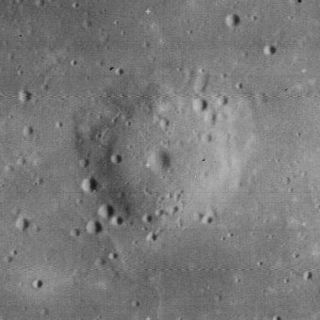
Ibn-Rushd is a lunar impact crater located to the northwest of the larger crater Cyrillus. To the northwest is the crater Kant and to the north is Mons Penck, a mountain promontory. The crater is somewhat eroded with age, and the southern rim is overlain by a pair of smaller craters named Cyrillus B and C. The crater floor is relatively flat, and lacks a central peak. In 1976 the crater was named after Ibn Rushd, a 12th-century Muslim polymath from Andalusia, whose many scientific accomplishments included analysis of the lunar surface. Prior to that, it was identified as Cyrillus B.
A lunar dome is a type of shield volcano that is found on the surface of the Earth's Moon. They are typically formed by highly viscous, possibly silica-rich lava, erupting from localized vents followed by relatively slow cooling. Lunar domes are wide, rounded, circular features with a gentle slope rising in elevation a few hundred meters to the midpoint. They are typically 8–12 km in diameter, but can be up to 20 km across. Some of the domes contain a small craterlet at the peak.

Mons Hadley is a massif in the northern portion of the Montes Apenninus, a range in the northern hemisphere of the Moon. It has a height of 4.2 km (14,000 ft) above the adjacent plain and a maximum diameter of 25 km at the base.

Mons La Hire is a solitary lunar mountain in the western Mare Imbrium. It is located to the northeast of the crater Euler, and to the west-northwest of Lambert.

Mons Vinogradov is a rugged massif that is located on the lunar mare where Oceanus Procellarum to the southwest joins Mare Imbrium to the east. There are three primary peaks in this formation, which rise to altitudes of 1.0–1.4 km above the surface. To the east of this rise is the crater Euler, and to the southeast is an area of rugged ground that reaches the Montes Carpatus range. The Carpatus mountain range forms the southwest boundary of the Mare Imbrium.

Maat Mons is a massive shield volcano. It is the second-highest mountain, and the highest volcano, on the planet Venus. It rises 8 kilometres (5.0 mi) above the mean planetary radius at 0.5°N 194.6°E, and nearly 5 km above the surrounding plains. It is named after the Egyptian goddess of truth and justice, Ma'at.

De Lalande is a multiring impact crater on Venus. It has a diameter of 21.6 km (13.4 mi) and wall width of 5.6 km (3.5 mi). The crater has an outer rim but no peak and is in close proximity to the volcano Gula Mons.
Elysium Mons is a volcano on Mars located in the volcanic province Elysium, at 25.02°N 147.21°E, in the Martian eastern hemisphere. It stands about 12.6 km (41,000 ft) above its base, and about 14.1 km (46,000 ft) above the Martian datum, making it the third tallest Martian mountain in terms of relief and the fourth highest in elevation. Its diameter is about 240 km (150 mi), with a summit caldera about 14 km (8.7 mi) across. It is flanked by the smaller volcanoes Hecates Tholus to the northeast, and Albor Tholus to the southeast.

Gale is a crater, and probable dry lake, on Mars near the northwestern part of the Aeolis quadrangle at 5.4°S 137.8°E. It is 154 km (96 mi) in diameter and estimated to be about 3.5-3.8 billion years old. The crater was named after Walter Frederick Gale, an amateur astronomer from Sydney, Australia, who observed Mars in the late 19th century. Aeolis Mons is a mountain in the center of Gale and rises 5.5 km (18,000 ft) high. Aeolis Palus is the plain between the northern wall of Gale and the northern foothills of Aeolis Mons. Peace Vallis, a nearby outflow channel, 'flows' down from the hills to the Aeolis Palus below and seems to have been carved by flowing water.

Ceraunius Fossae is an area of intensely fractured terrain in the northern Tharsis region of Mars. It lies directly south of the large volcano Alba Mons and consists of ancient highland crust that has been deformed by numerous parallel faults and tension cracks. In places, younger lava flows cover the fractured terrain, dividing it into several large patches or islands. It is found in the Tharsis quadrangle.

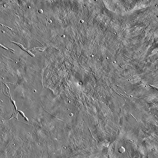
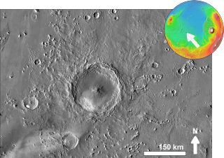
Ceraunius Tholus is a volcano on Mars located in the Tharsis quadrangle at 24.25° north latitude and 262.75° east longitude, part of the Uranius group of volcanoes. It is 130 km across, 5.5 km high and is named after a classical albedo feature name.
Pettit Crater is a crater in the Amazonis quadrangle of Mars, located at 12.39° north latitude and 173.87° west longitude. Pettit lies west of the giant volcano Olympus Mons. It is 92.49 km in diameter and was named after Edison Pettit, an American astronomer (1890–1962).
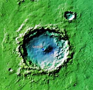
Lockyer is a crater in the Elysium quadrangle of Mars, located at 28° North and 199.5° West. It is 71 km in diameter and was named after Norman Lockyer, a British astronomer (1836-1920). Lockyer is fairly easy to spot on Mars maps because it sits in the relatively young northern hemisphere, where there are few craters. It is close to Elysium Mons and Hecates Tholus, two large volcanoes.

Orcus Patera is a region on the surface of the planet Mars first imaged by Mariner 4. It is a depression about 380 km long, 140 km wide, and about 0.5 km deep but with a relatively smooth floor. It has a rim up to 1.8 km high. Orcus Patera is west of Olympus Mons and east of Elysium Mons. It is about halfway between those two volcanoes, and east and north of Gale crater.
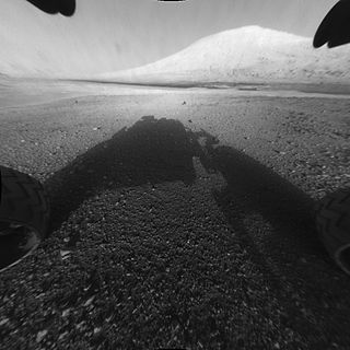
Mount Sharp, officially Aeolis Mons, is a mountain on Mars. It forms the central peak within Gale crater and is located around 5.08°S 137.85°E, rising 5.5 km (18,000 ft) high from the valley floor. It has the ID of 15,000 in the Gazetteer of Planetary Nomenclature from the US Geological Survey.

Peace Vallis is an valley network in Gale Crater in the Aeolis quadrangle on the planet Mars; it appears to have been carved by fluids, perhaps water. The valley 'flows' southeast down out of the hills of Gale Crater to Aeolis Palus below near "Mount Sharp" and is centered 4.21°S 137.23°E. Peace Vallis is near the landing site of the Curiosity rover which started studying the valley in 2012. The name, Peace Vallis, was officially adopted by the IAU on September 26, 2012.