Related Research Articles
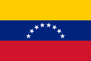
Venezuela, officially the Bolivarian Republic of Venezuela, is a country on the northern coast of South America, consisting of a continental landmass and many islands and islets in the Caribbean Sea. It has a territorial extension of 916,445 km2 (353,841 sq mi), and its population was estimated at 29 million in 2022. The capital and largest urban agglomeration is the city of Caracas.

Venezuela is a country in South America, bordering the Caribbean Sea and the North Atlantic Ocean, between Colombia and Guyana. It is situated on major sea and air routes linking North and South America. Located at the northernmost end of South America, Venezuela has a total area of 912,050 km2 (352,140 sq mi) and a land area of 882,050 km2 (340,560 sq mi). It is the 32nd largest country and is slightly smaller than Egypt, or half the size of Mexico. Shaped roughly like an inverted triangle, the country has a 2,800 km (1,700 mi) long coastline. It is bound on the north by the Caribbean Sea and the Atlantic Ocean, on the east by Guyana, on the south by Brazil, and on the west by Colombia. It has the 55th largest Exclusive Economic Zone of 471,507 km2 (182,050 sq mi). Its maritime territory borders Trinidad and Tobago, Dominica, the Dominican Republic, Grenada, St. Kitts and Nevis, St. Vincent and the Grenadines, France, the United Kingdom, the Netherlands, and the United States. Venezuela also claims the region of Guayana Esequiba, currently under the control of Guyana.

Caracas, officially Santiago de León de Caracas, abbreviated as CCS, is the capital and largest city of Venezuela, and the center of the Metropolitan Region of Caracas. Caracas is located along the Guaire River in the northern part of the country, within the Caracas Valley of the Venezuelan coastal mountain range. The valley is close to the Caribbean Sea, separated from the coast by a steep 2,200-meter-high (7,200 ft) mountain range, Cerro El Ávila; to the south there are more hills and mountains. The Metropolitan Region of Caracas has an estimated population of almost 5 million inhabitants.

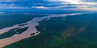
The Orinoco is one of the longest rivers in South America at 2,250 kilometres (1,400 mi). Its drainage basin, sometimes known as the Orinoquia, covers 989,000 km2 (382,000 sq mi), with 76.3 percent of it in Venezuela and the remainder in Colombia. It is the fourth largest river in the world by discharge volume of water. The Orinoco River and its tributaries are the major transportation system for eastern and interior Venezuela and the Llanos of Colombia. The environment and wildlife in the Orinoco's basin are extremely diverse.
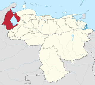
Zulia State is one of the 23 states of Venezuela. The state capital is Maracaibo. As of the 2011 census, it has a population of 3,704,404, the largest population among Venezuela's states. It is also one of the few states in Venezuela in which voseo is widespread. The state is coterminous with the eponymous region of Zulia.

Aragua State is one of the 23 states of Venezuela. It is located in the north-central region of Venezuela. It has plains and jungles and Caribbean beaches. The most popular are Cata and Choroni. It has Venezuela's first national park which is called Henri Pittier. The capital is Maracay, other important cities include Turmero and El Limón.

Valencia is the capital city of Carabobo State and the third-largest city in Venezuela.

Carabobo State is one of the 23 states of Venezuela, located in the north of the country, about two hours by car from Caracas. The state capital city is Valencia, which is also the country's main industrial center. The state's area is 4,369 km2 (1,687 sq mi) and as of the 2011 census, had a population of 2,245,744.
The Essequibo River is the largest river in Guyana, and the largest river between the Orinoco and Amazon. Rising in the Acarai Mountains near the Brazil–Guyana border, the Essequibo flows to the north for 1,014 kilometres (630 mi) through forest and savanna into the Atlantic Ocean. With a total drainage basin of 156,828 square kilometres (60,552 sq mi) and an average discharge of 4,531–5,650 cubic metres per second (160,000–199,500 cu ft/s).

Vichada Department is a department of the Republic of Colombia in South America. Vichada is located in the eastern plains of Colombia, in the Orinoquía Region within the Orinoco river basin bordering the Bolivarian Republic of Venezuela to the north and east. To the north the department also borders with Arauca Department, to the northwest with Casanare Department, to the west with Meta Department, to the southwest narrowly bordering with Guaviare Department and to the south with Guainía Department. The department is the second largest in Colombia and scarcely populated in comparison to other departments.

Amazonas State is one of the 23 states into which Venezuela is divided. It covers nearly a fifth of the area of Venezuela, but has less than 1% of Venezuela's population.

Apure State is one of the 23 states of Venezuela. Its territory formed part of the provinces of Mérida, Maracaibo, and Barinas, in accordance with successive territorial ordinations pronounced by the colonial authorities. In 1824 the Department of Apure was created, under jurisdiction of Barinas, which laid the foundations for the current entity. In 1856 it separated from Barinas and for the first time Apure appeared as an independent province, which in 1864 acquired the status of state. In 1881, however, a new territorial division combined Apure and Guayana to form a single state named Bolívar. In 1899 it reestablished its autonomy and finally, by means of the Constitution of 1909, gained its current borders.

Bolívar is one of the 23 states of Venezuela. The state capital city is Ciudad Bolívar, but the largest city is Ciudad Guayana. Bolívar State covers a total surface area of 242,801 km2 (93,746 sq mi) and as of the 2011 census, had a population of 1,410,964. The state contains Angel Falls.

Delta Amacuro State is one of the 23 states of Venezuela, and is the location of the Orinoco Delta. The Paria Gulf and the Atlantic Ocean are found to the north, Bolívar State is found to the south, the Atlantic Ocean and Guyana are found to the east, and Monagas State is found to the west. The state capital city is Tucupita.

Guárico State is one of the 23 states of Venezuela. The state capital is San Juan de Los Morros. Guárico State covers a total surface area of 64,986 km2 (25,091 sq mi) and, in 2011, had a census population of 747,739. It is named for the Guárico River.
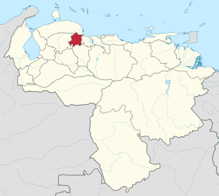
Yaracuy is one of the 23 states of Venezuela. Yaracuy is located in the Central-Western Region, Venezuela. It is bordered by Falcón in the north, in the west by Lara, in the south by Portuguesa and Cojedes and in the east by Cojedes and Carabobo.

The Bolivarian Republic of Venezuela is a federation made up of twenty-three states, a Capital District and the Federal Dependencies, which consist of many islands and islets in the Caribbean Sea. Venezuela also claims the Guayana Esequiba territory which comprises six districts in the independent nation of Guyana.

The Cordillera Oriental is the widest of the three branches of the Colombian Andes. The range extends from south to north dividing from the Colombian Massif in Huila Department to Norte de Santander Department where it splits into the Serranía del Perijá and the Cordillera de Mérida in Venezuelan Andes. The highest peak is Ritacuba Blanco at 5,410 m (17,750 ft) in the Sierra Nevada del Cocuy.

Guayana Esequiba, sometimes also called Esequibo or Essequibo, is a disputed territory of 159,500 km2 (61,600 sq mi) west of the Essequibo River that is administered and controlled by Guyana but claimed by Venezuela. The boundary dispute was inherited from the colonial powers and has been complicated by the independence of Guyana from the United Kingdom in 1966.

Guyana, officially the Co‑operative Republic of Guyana, is a country on the northern mainland of South America. Guyana is an indigenous word which means "Land of Many Waters". The capital city is Georgetown. Guyana is bordered by the Atlantic Ocean to the north, Brazil to the south and southwest, Venezuela to the west, and Suriname to the east. With 215,000 km2 (83,000 sq mi), Guyana is the third-smallest sovereign state by area in mainland South America after Uruguay and Suriname, and is the second-least populous sovereign state in South America after Suriname; it is also one of the least densely populated countries on Earth. It has a wide variety of natural habitats and a very high biodiversity.
References
- Rand McNally, The New International Atlas, 1993.