
This is a list of sites in Minnesota which are included in the National Register of Historic Places. There are more than 1,600 properties and historic districts listed on the NRHP; each of Minnesota's 87 counties has at least 2 listings. Twenty-two sites are also National Historic Landmarks.

This is intended to be a complete list of the properties and districts on the National Register of Historic Places in Fairfield County, Connecticut, United States. The locations of National Register properties and districts for which the latitude and longitude coordinates are included below, may be seen in an online map.

Harmony Hall, located in Fort Washington, Maryland, is managed by the United States National Park Service as part of the National Capital Parks-East system. It has been a National Park Service site since 1966. Harmony Hall is a 2 1⁄2-story Georgian country house built of red brick during the eighteenth century. It is surrounded by 65 acres (26 ha) of land on Broad Creek, a Potomac River tributary.

This is a list of the National Register of Historic Places listings in Dakota County, Minnesota. It is intended to be a complete list of the properties and districts on the National Register of Historic Places in Dakota County, Minnesota, United States. Dakota County is located in the southeastern part of the U.S. state of Minnesota, bounded on the northeast side by the Upper Mississippi River and on the northwest by the Minnesota River. The locations of National Register properties and districts for which the latitude and longitude coordinates are included below, may be seen in an online map.

This list is of the properties and historic districts that are designated on the National Register of Historic Places or that were formerly so designated, in Hennepin County, Minnesota; there are 169 entries as of November 2018. A significant number of these properties are a result of the establishment of Fort Snelling, the development of water power at Saint Anthony Falls, and the thriving city of Minneapolis that developed around the falls. Many historic sites outside the Minneapolis city limits are associated with pioneers who established missions, farms, and schools in areas that are now suburbs in that metropolitan area.

This is a list of the National Register of Historic Places listings in Morrison County, Minnesota. It is intended to be a complete list of the properties and districts on the National Register of Historic Places in Morrison County, Minnesota, United States. The locations of National Register properties and districts for which the latitude and longitude coordinates are included below, may be seen in an online map.

The Inns on the National Road is a national historic district near Cumberland, Allegany County, Maryland. It originally consisted of 11 Maryland inns on the National Road and located in Allegany and Garrett counties. Those that remain stand as the physical remains of the almost-legendary hospitality offered on this well-traveled route to the west.

This is a list of the National Register of Historic Places listings in Pitkin County, Colorado.

This is a list of the National Register of Historic Places listings in Meeker County, Minnesota.
This is a list of the properties and historic districts in Stamford, Connecticut that are listed on the National Register of Historic Places. The locations of National Register properties and districts for which the latitude and longitude coordinates are included below, may be seen in a Google map.
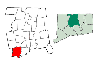
This is a list of the National Register of Historic Places listings in Southington, Connecticut.

Pinery Station, or The Pinery, was built as a relay station on the Butterfield Overland Mail stagecoach route, located at the crest of Guadalupe Pass in what is now Guadalupe Mountains National Park in the U.S. state of Texas. The station, now in ruins, was built in 1858 and was abandoned the next year. It is located close by US 62/160 and is accessible for tourists.

The Montezuma Fuller House at 226 W. Magnolia St. in Fort Collins, Colorado was built in 1894. It is a Queen Anne style house designed by architect Montezuma Fuller. It was listed on the National Register of Historic Places (NRHP) in 1978.
The McHugh–Andrews House at 202 Remington St. in Fort Collins, Colorado was built in 1885. It was designed by builder-architect Montezuma Fuller and it was also a work of Lars P. Kemoe. It was listed on the National Register of Historic Places in 1978.

Winstead Hill is a property in Franklin, Tennessee that has significance in 1864 for being in the Second Battle of Franklin battlefield. It is located within the Franklin Battlefield, a U.S. National Historic Landmark area.

The Fort Street Historic District in Boise, Idaho, contains roughly 47 blocks located within the 1867 plat of Boise City. The irregular shape of the district is roughly bounded on the north by West Fort Street and on the south by West State Street. The west boundary is North 16th Street, and the east boundary is roughly North 5th Street.


