Mottram in Longdendale (ancient parish)

Last updated

Coordinates: 53°27′32″N2°00′43″W / 53.459°N 2.012°W / 53.459; -2.012

Geographic coordinate system Coordinate system

A geographic coordinate system is a coordinate system that enables every location on Earth to be specified by a set of numbers, letters or symbols. The coordinates are often chosen such that one of the numbers represents a vertical position and two or three of the numbers represent a horizontal position; alternatively, a geographic position may be expressed in a combined three-dimensional Cartesian vector. A common choice of coordinates is latitude, longitude and elevation. To specify a location on a plane requires a map projection.

Contents

St Michael and All Angels Church at the centre of the parish Mottram Church 01.JPG
St Michael and All Angels Church at the centre of the parish

Mottram in Longdendale was one of the eight ancient parishes of the Macclesfield Hundred of Cheshire, England. [1] Centred on St Michael and All Angels Church it included the townships of Godley, Hattersley, Hollingworth, Matley, Newton, Stayley, Tintwistle and Mottram itself. [1] Under the Poor Law Amendment Act 1886 the townships became civil parishes in their own right.

Cheshire County of England

Cheshire is a county in North West England, bordering Merseyside and Greater Manchester to the north, Derbyshire to the east, Staffordshire and Shropshire to the south and Flintshire, Wales and Wrexham county borough to the west. Cheshire's county town is the City of Chester (118,200); the largest town is Warrington (209,700). Other major towns include Crewe (71,722), Ellesmere Port (55,715), Macclesfield (52,044), Northwich (75,000), Runcorn (61,789), Widnes (61,464) and Winsford (32,610)

St Michael and All Angels Church, Mottram Church in Greater Manchester, England

St Michael and All Angels Church stands on Warhill overlooking the village of Mottram in Longdendale, Greater Manchester, England. The church is recorded in the National Heritage List for England as a designated Grade II* listed building. It is an active Anglican parish church in the diocese of Chester, the archdeaconry of Macclesfield and the deanery of Mottram.

Godley, Greater Manchester suburb in Hyde, Greater Manchester

Godley is a suburb of Hyde, Greater Manchester, England.

Inclusion in municipal boroughs

In 1857 an area of the Stayley township was incorporated as part of the newly created municipal borough of Stalybridge [2] and in 1881 the civil parishes of Godley and Newton were incorporated as part of the new Hyde Municipal Borough. [3] In 1885 the municipal borough of Mossley was created and included parts of Tintwistle and Stayley civil parishes.

Stalybridge town in the Metropolitan Borough of Tameside in Greater Manchester, England

Stalybridge is a town in Tameside, Greater Manchester, England, with a population of 23,731 at the 2011 Census. Historically part of Cheshire, it is 8 miles (12.9 km) east of Manchester city centre and 6 miles (9.7 km) north-west of Glossop.

Mossley town in Tameside, Greater Manchester, England

Mossley (/ˈmɒzli/) is a small town and a civil parish in Greater Manchester, England, in the upper Tame Valley and the foothills of the Pennines, 3 miles (4.8 km) southeast of Oldham and 8.9 miles (14.3 km) east of Manchester.

Boundary changes

Stayley Hall, the medieval seat of the lords of the Stayley township Staleyhall.jpg
Stayley Hall, the medieval seat of the lords of the Stayley township

Local Government Act 1894

Under the Local Government Act 1894 several changes came into effect on 31 December of that year. Most of Tintwistle civil parish became part of the new Tintwistle Rural District, [4] with the civil parishes of Hattersley and Matley forming an exclave of the district; [5] On the same day, the new civil parish of Mossley was created and those parts of Tintwistle and Stayley that had been included in the boundaries of the Mossley municipal borough were transferred to the new parish. [6] The rest of the area of Stayley civil parish was transferred to the new civil parish of Stalybridge. [7] Hollingworth civil parish was incorporated as the new, single parish Hollingworth Urban District [8] and the civil parish of Mottram itself became incorporated as the single parish Mottram Urban District. [1]

Local Government Act 1894

The Local Government Act 1894 was an Act of the Parliament of the United Kingdom that reformed local government in England and Wales outside the County of London. The Act followed the reforms carried out at county level under the Local Government Act 1888. The 1894 legislation introduced elected councils at district and parish level.

Tintwistle Rural District was a local government district in north east Cheshire, England from 1894 to 1974.

On 1 October 1923 Godley and Newton civil parishes were abolished and their areas became part of Hyde civil parish. [9]

Local Government Act 1929

Under a review conducted under the Local Government Act 1929 the boundaries of Cheshire were adjusted on 1 April 1936.Hollingworth and Mottram in Longendale civil parishes and urban districts were abolished and they were both included in the new Longendale civil parish and Urban District. [10] Hattersley and Matley civil parishes were abolished and their area, which had been an exclave of Tintwistle Rural District, were divided between Stalybridge CP, Hyde CP and the new Longendale CP. [4] Hyde CP gained 722 acres (2.92 km2) of Hattersley and 307 acres (1.24 km2) of Matley. [11] Longendale CP gained a total of 375 acres (1.52 km2) from Hattersley and Matley. [10] Stalybridge CP gained 58 acres (230,000 m2) of Matley. [12]

Local Government Act 1929 local government-related UK parliament act of 1929

The Local Government Act 1929 was an Act of the Parliament of the United Kingdom that made changes to the Poor Law and local government in England and Wales.

In England and Wales, Northern Ireland, and the Republic of Ireland, an urban district was a type of local government district that covered an urbanised area. Urban districts had an elected urban district council (UDC), which shared local government responsibilities with a county council.

Related Research Articles

Longdendale village in the United Kingdom

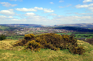
Longdendale is a valley in the Peak District of England, north of Glossop and southwest of Holmfirth. The name means "long wooded valley" and the valley marks the boundary between the counties of Derbyshire and Greater Manchester.

Tameside Metropolitan borough in England

The Metropolitan Borough of Tameside is a metropolitan borough of Greater Manchester in North West England. It is named after the River Tame, which flows through the borough and spans the towns of Ashton-under-Lyne, Audenshaw, Denton, Droylsden, Dukinfield, Hyde, Mossley and Stalybridge plus Longdendale. Its western border is approximately 4 miles (6.4 km) east of Manchester city centre. It borders High Peak in Derbyshire to the east, the Metropolitan Borough of Oldham to the north, the Metropolitan Borough of Stockport to the south, and the City of Manchester to the west. As of 2011 the overall population was 219,324.

River Etherow river in north west England

The River Etherow is a river in northern England, and a tributary of the River Goyt. Although now passing through South Yorkshire, Derbyshire and Greater Manchester, it historically formed the ancient county boundary between Cheshire and Derbyshire. The upper valley is known as Longdendale. The river has a watershed of approximately 30 square miles (78 km2), and the area an annual rainfall of 52.5 inches (1,330 mm).

Mottram in Longdendale village in United Kingdom

Mottram in Longdendale is an unparished village within the Metropolitan Borough of Tameside, in Greater Manchester, England. The 2011 Census for the ward of Longdendale which includes Mottram and the surrounding area was 9,950.

M67 motorway motorway in Greater Manchester, England

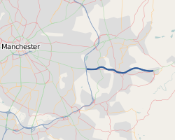
The M67 is a 5-mile (8.0 km) urban motorway in Greater Manchester, England, which heads east from the M60 motorway passing through Denton and Hyde before ending near Mottram. It was originally conceived as the first part of a trans-Pennine motorway between Manchester and Sheffield connecting the A57(M) motorway to the M1 motorway; however, the motorway never progressed this far.

Hyde, Greater Manchester town in the Metropolitan Borough of Tameside, Greater Manchester, England

Hyde is a town in Tameside, Greater Manchester, England, which in 2011 had a population of 34,003.

Hollingworth village in United Kingdom

Hollingworth is a village in the Metropolitan Borough of Tameside, in Greater Manchester, England. It is about 12 miles (19 km) east of Manchester on the Derbyshire border near Glossop. Historically part of Cheshire, it gave its name to a family who owned much of the surrounding area from before the time of the Norman conquest.

Hattersley human settlement in United Kingdom

Hattersley is an area of Tameside, Greater Manchester, England, 4 miles (6.4 km) west of Glossop and 10 miles (16 km) east of Manchester city centre at the eastern terminus of the M67. Historically part of Tintwistle Rural District in Cheshire until 1974, it is the site of an overspill estate built by Manchester City Council in the 1960s.

Civil parishes in Cheshire Wikimedia list article

A civil parish is a country subdivision, forming the lowest unit of local government in England. There are 333 civil parishes in the ceremonial county of Cheshire, most of the county being parished. At the 2001 census, there were 565,259 people living in 332 parishes, accounting for 57.5 per cent of the county's population.

Civil parishes in Greater Manchester Wikimedia list article

A civil parish is a country subdivision, forming the lowest unit of local government in England. There are 15 civil parishes in the ceremonial county of Greater Manchester, most of the county being unparished; Bury, Rochdale, Salford and Stockport are completely unparished. At the 2001 census, there were 129,325 people living in the 15 civil parishes, accounting for 5.2% of the county's population.

Stalybridge and Hyde (UK Parliament constituency) Parliamentary constituency in the United Kingdom

Stalybridge and Hyde is a constituency represented in the House of Commons of the UK Parliament since 2010 by Jonathan Reynolds, a member of the Labour Party and the Cooperative Party.

Hyde was a county constituency represented in the House of Commons of the Parliament of the United Kingdom from 1885 until 1918. It was seated in the town of Hyde, Cheshire.

Longdendale Bypass future road in England

The Longdendale Bypass is a long-planned road scheme in England by the Highways Agency. The aim is to alleviate traffic congestion on the A57 road/A628 road/A616 road routes that presently pass through the villages. There is both support and opposition for this long-planned scheme which will pass through the valley of Longdendale and part of the Peak District National Park.

Matley human settlement in United Kingdom

Matley is a semi-rural area of Greater Manchester, England. It is located in the Metropolitan Borough of Tameside between the towns of Stalybridge, Hyde and Dukinfield. Matley was a township of Mottram in Longdendale, one of the eight ancient parishes of the Macclesfield Hundred of Cheshire. Under the Poor Law Amendment Act 1886 the township became civil parish in its own right. Between 1894 and 1936 Matley was a civil parish in the Tintwistle Rural District of Cheshire. The parish was abolished in 1936 and its former area was divided between the municipal boroughs of Stalybridge, Hyde and Dukinfield. In 1974 these boroughs were abolished and their former areas transferred to Greater Manchester to form part of the present-day Metropolitan Borough of Tameside.

Longendale Urban District

Longendale Urban District was, from 1936 to 1974, a local government district in the administrative county of Cheshire, England. It encompassed parts of Broadbottom, Hattersley, Hollingworth, Matley and Mottram in Longdendale, all of which form part of the non-statutory Longdendale Valley.

A628 road major road in the north of England

The A628 is a major road in England connecting Greater Manchester and South Yorkshire by crossing the Pennine chain of hills by way of the Woodhead Pass through the Peak District National Park. The road's altitude and its exposure to bad weather create problems in winter and the road is sometimes closed due to snow or high winds.

References

  1. 1 2 3 A Vision of Britain: Mottram in Longdendale Ancient Parish/Civil Parish
  2. A Vision of Britain: Stalybridge municipal borough Archived 2008-04-30 at the Wayback Machine .
  3. A Vision of Britain: Hyde Municipal Borough Archived 2007-10-01 at the Wayback Machine .
  4. 1 2 A Vision of Britain: Tintwistle Rural District Archived 2011-05-14 at the Wayback Machine .
  5. A Vision of Britain: Tintwistle Rural District boundary map
  6. A Vision of Britain: Mossley civil parish [ permanent dead link ]
  7. A Vision of Britain: Stayley Township/Civil Parish [ permanent dead link ]
  8. A Vision of Britain: Hollingworth Urban District [ permanent dead link ]
  9. A Vision of Britain: Godley Township/Civil Parish Archived 2007-10-01 at the Wayback Machine .
  10. 1 2 A Vision of Britain: Longendale Urban District Archived 2012-10-25 at the Wayback Machine .
  11. A Vision of Britain: Hyde Civil Parish [ permanent dead link ]
  12. A Vision of Britain: Matley Township/Civil Parish [ permanent dead link ]