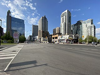
North York City Centre is a central business district in Toronto, Ontario, Canada in the administrative district of North York. It is located along Yonge Street, between just south of Sheppard Avenue northward to Finch Avenue with its focus around Mel Lastman Square, a civic square, and spreads eastwards and westwards a few blocks, generally as far as Doris Avenue and Beecroft Road. The district is a high-density district of condominium and office towers with ground-floor commercial uses along the wide six lanes of Yonge Street.

The George Brown College of Applied Arts and Technology is a public, fully accredited college of applied arts and technology with three campuses in downtown Toronto. Like many other colleges in Ontario, George Brown College was chartered in 1966 by the government of Ontario and opened the next year.
The Whitney Block is a Government of Ontario office building located in Toronto, Ontario, Canada. It is located across the street from the Ontario Legislative Building, and contains the offices of the Premier of Ontario and most cabinet ministers. The street address of Whitney Block is 99 Wellesley Street West, though the principal facade faces west towards Queen's Park Crescent and the Ontario Legislature. The building is linked to the legislature by a tunnel under the street, by a bridge to the Macdonald Block, and through there via another tunnel to the subway. The Modern Gothic-Art Deco structure was built in 1926 by architect F. R. Heakes and the tower was added in 1932. Whitney Block is faced with Queenston limestone. The facade is ornamented by repeated sequences of quatrefoils, and figures designed by Charles Adamson, which represent abstract ideals like justice, tolerance, wisdom and power, as well as more ordinary pursuits such a mining, forestry, labour, law, education and farming. The floors are made of marble mined in Bancroft.
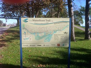
Stretching over 3600 km from Prince Township, west of Sault Ste. Marie, to the Quebec border, the Great Lakes Waterfront Trail is a signed route of interconnecting roads and off-road trails joining over 150 communities and First Nations along the Canadian shores of the Great Lakes and St. Lawrence River. A celebration of nature and culture, the Great Lakes Waterfront Trail is part of a strategy to protect and connect people to the largest group of freshwater lakes on earth. It is a legacy project of the Waterfront Regeneration Trust, a charity, and its community partners. Through Toronto, the trail is called the Martin Goodman Trail. The Waterfront Trail is also used by commuters in parts of Southern Ontario.

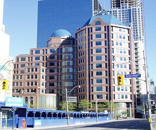
The Frost Building is a curved 7 and 6 storey office building complex on the south east side of Queen's Park Crescent in Toronto, Ontario, Canada. The Government of Ontario owns the building and is part of the large Queen's Park campus. The Frost Building is home to the Ontario Ministry of Finance and Treasury Board Secretariat. It is divided into a North block, located on 95 Grosvenor St, and a South block, located on 7 Queen's Park Crescent. A five-storey glass walkway connects the two blocks from the 2nd and 6th floors.

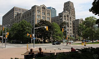
The Ontario Legislative Building is a structure in central Toronto, Ontario, Canada. It houses the Legislative Assembly of Ontario, and the viceregal suite of the Lieutenant Governor of Ontario and offices for members of the provincial parliament (MPPs). The building is surrounded by Queen's Park, sitting on that part south of Wellesley Street, which is the former site of King's College, which was leased from the university by the municipal government of Toronto in 1859, for a "peppercorn" payment of CAD$1 per annum on a 999-year term. The southern portion of the site was later handed over to the provincial government.

The Workmen's Compensation Board Building was a five-storey office building in Toronto, Ontario. It was originally home to the Workers Compensation Board of Ontario from 1953 to 1973. It was designed by the province's master architect, George N. William.

The Toronto Normal School was a teachers college in Toronto, Ontario, Canada. Opened in 1847, the Normal School was located at Church and Gould streets in central Toronto, and was a predecessor to the current Ontario Institute for Studies in Education. The Royal Ontario Museum, the Ontario College of Art & Design and the Ontario Agricultural College all originated at the Normal School's campus and the provincial Department of Education was also located there. Officially named St. James Square, the school became known as "the cradle of Ontario's education system". The school's landmark Gothic-Romanesque building was designed by architects Thomas Ridout and Frederick William Cumberland in 1852. The landmark building was demolished in 1963, but architectural elements of the structure remain on the campus of Toronto Metropolitan University.
Toronto Police Headquarters is the headquarters of the Toronto Police Service, located at 40 College Street in Toronto, Ontario, Canada. It is the first purpose-built police headquarters in Toronto since the formation of the city's original police force in 1835.

545 Lake Shore Boulevard West is a former media studio complex located along the harbourfront of Toronto, Ontario, Canada, at the intersection of Bathurst Street and Lake Shore Boulevard West.

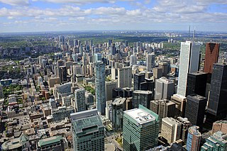
Downtown Toronto is the main central business district of Toronto, Ontario, Canada. Located entirely within the district of Old Toronto, it is approximately 16.6 square kilometres in area, bounded by Bloor Street to the northeast and Dupont Street to the northwest, Lake Ontario to the south, the Don Valley to the east, and Bathurst Street to the west. It is also the home of the municipal government of Toronto and the Government of Ontario.
Midtown is one of four central business districts outside the city's downtown core of Toronto, Ontario, Canada. Located in the north of Old Toronto, its borders are roughly defined by St. Clair Avenue to the south and Eglinton Avenue or Lawrence Avenue to the north, Bayview Avenue to the east and Dufferin Street to the west. The central neighbourhood of the area is Yonge–Eglinton.

Shore Tilbe Perkins+Will, formerly Shore Tilbe Irwin & Partners (STIP), is a Canadian architecture firm based in Toronto, Ontario. Since its founding as Shore and Moffat in 1945, and later as Shore Tilbe Irwin & Partners, the firm has completed numerous buildings, complexes and master plans across Canada, as well as at locations in the United States and Bermuda. From early educational and residential projects, the firm rose to prominence in the early 1950s, winning Governor General's Medals in Architecture and commissions from the government of Ontario for departmental buildings, and it went on to design prominent landmarks such as Purdy's Wharf in Halifax, Nova Scotia, and the redesign of Nathan Phillips Square in Toronto. The firm's scope today mostly encompasses community centres, libraries, pharmaceutical laboratories, offices and university teaching buildings, although the firm has also completed religious spaces, corporate interiors and public plazas.

Stephen Van Egmond Irwin RAIC, RIBA, OAA, BArch, MArch was a Canadian architect and "partner emeritus" of Shore Tilbe Irwin + Partners in Toronto, Ontario.

The Whitby Public Library is a public library that serves the town of Whitby, Ontario, Canada, with three branches. The library is governed through a ten-person library board appointed by the town, and operated by a staff of more than 80 full and part-time employees. As of 2016, there were over 1.4 million items circulated and the system had a CA$5,700,000 budget.

The Rogers Building, located in Toronto, Ontario, Canada, is part of the corporate campus of Canadian media conglomerate Rogers Communications, as well as the home of most, but not all, of the company's Toronto operations.

The Ontario Food Terminal is the main produce distribution centre for Toronto, Ontario, Canada. It is located at 165 The Queensway at Park Lawn Road, north of the Gardiner Expressway, and west of the Humber River. The U-shaped building occupies 1,740,000 square feet (162,000 m2) of a 40 acres (16 ha) site and includes 80,000 square feet (7,400 m2) of cold storage and is open 24 hours a day, 365 days a year for deliveries. Annually some one million vehicles arrive at the centre delivering produce from across North America or leave to distribute it to stores and restaurants across the city. It is the largest such facility in Canada, and the third largest in North America after those in Chicago and Los Angeles.

The Macdonald Block Complex is a set of office buildings in Toronto, Ontario, Canada, that houses 12 cabinet ministers, 15 Ontario government ministries and the largest concentration of Ontario public servants. Its address is 900 Bay Street, and is located just east of Queen's Park.
The Downsview Complex is a provincial office site located in the Downsview neighbourhood of Toronto, Ontario, Canada.

The John Irwin House is a historic structure located in Toronto, one of the oldest surviving residential buildings in its neighbourhood. The house is listed on the City of Toronto government's registry of historic properties. The city describes the house as being an example of "Second Empire" style. The house is located at 21 Grenville Street. That part of the city, east of Queen's Park, was opened for residential development in 1860, and the house was recorded on city records as being owned by John Irwin in 1873.
