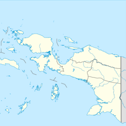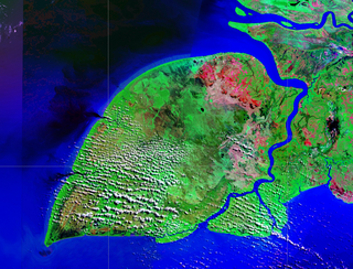
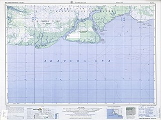
Pulau Yos Sudarso or Pulau Dolok is an island separated only by the narrow Muli Strait from the main island of New Guinea. It is part of the Merauke Regency, in the Indonesian province of South Papua. The island is leaf-shaped, about 165 km (103 mi) long with an area of 11,740 km2 (4,530 sq mi). It was known as Frederik Hendrik Island until 1963. Local and alternative names of the island include Dolok, Kimaam and Kolepom.

Commodore Yosaphat "Yos" Sudarso was an Indonesian naval officer killed at the Battle of Arafura Sea. At the time of his death, Yos Sudarso was deputy chief of staff of the Indonesian Navy and in charge of an action to infiltrate Dutch New Guinea. He was promoted to vice admiral posthumously.

The Digul River is a major river in southern Papua province, Indonesia, on the island of New Guinea. It is the fourth longest river in New Guinea after Sepik River, Mamberamo River and Fly River. With a total length of 853 km (530 mi) and has a drainage basin of 45,900 km2 (17,700 sq mi).

Yos Sudarso Bay, known as Humboldt Bay from 1827 to 1968, is a small bay on the north coast of New Guinea, about 50 kilometers west of the border between Indonesia's province of Papua and the country of Papua New Guinea. The Indonesian provincial capital Jayapura is situated on the bay.
Komoran or Komolom is an island just south of the much larger Yos Sudarso near the south coast of New Guinea in South Papua province, Indonesia. Its area is 695 km².
Ndom is a language spoken on Yos Sudarso Island in Papua province, Indonesia. It is reported to have numbers in senary. A problem from the 2007 International Linguistics Olympiad focused on this number system.

The Mombum languages, also known as the Komolom or Muli Strait languages, are a pair of Trans–New Guinea languages, Mombum (Komolom) and Koneraw, spoken on Komolom Island just off Yos Sudarso Island, and on the southern coast of Yos Sudarso Island, respectively, on the southern coast of New Guinea. Komolom Island is at the southern end of the Muli Strait.
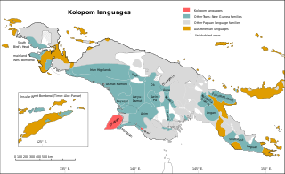
The Kolopom languages are a family of Trans–New Guinea languages in the classifications of Stephen Wurm (1975) and of Malcolm Ross (2005). Along with the Mombum languages, they are the languages spoken on Yos Sudarso Island.
KIG may refer to either one of these things:
Kimaama, or Kimaghama, is a language spoken on Yos Sudarso Island in Papua province, Indonesia.
Riantana, or Kimaam, is a language spoken on Yos Sudarso Island in Papua province, Indonesia.
Mombum, or Kemelom (Komolom), is a Trans–New Guinea language spoken on Yos Sudarso Island in West New Guinea.

The Battle of Arafura Sea, also known as the Battle of Vlakke Hoek, was a naval battle in the Vlakke Hoek Bay of the Arafura Sea in Western New Guinea on January 15, 1962, between Indonesia and the Netherlands.

The Ahmad Yani class of six general-purpose frigates were acquired by the Indonesian Navy in the 1980s. They were originally built in the Netherlands for the Royal Netherlands Navy as the Van Speijk class which were licence-built versions of the British Leander class.
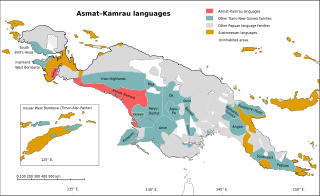
The Asmat–Muli Strait languages are a branch of the Trans–New Guinea languages spoken along the southern coast of Indonesian New Guinea, established by Timothy Usher and Edgar Suter.
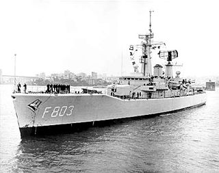
HNLMS Van Galen (F803) was a frigate of the Van Speijk class. The ship was in service with the Royal Netherlands Navy from 1967 to 1987. The frigate was named after Dutch naval hero Johan van Galen. The ship's radio call sign was "PAVB". She was sold to the Indonesian Navy where the ship was renamed KRI Yos Sudarso (353).
Cape Kombies is a cape on the southwestern coast of New Guinea, near Yos Sudarso Island, in Papua Province, New Guinea.
Kimaam is a village in Kimaam district, Merauke Regency in South Papua province, Indonesia. Its population is 746. It is on Yos Sudarso Island.
This page is based on this
Wikipedia article Text is available under the
CC BY-SA 4.0 license; additional terms may apply.
Images, videos and audio are available under their respective licenses.