This page is based on this
Wikipedia article Text is available under the
CC BY-SA 4.0 license; additional terms may apply.
Images, videos and audio are available under their respective licenses.
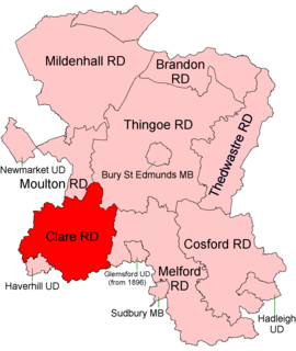
Clare Rural District was a rural district in the county of West Suffolk, England. It was created in 1894, comprising those parishes in the Risbridge rural sanitary district which were in Suffolk.

Thingoe Rural District was a rural district in the county of West Suffolk, England. It was created in 1894. On 1 April 1935 the parish of Depden was transferred to the Clare Rural District. On the same date the district was enlarged by the transfer of the civil parishes of Barnham, Barningham, Coney Weston, Euston, Fakenham Magna, Hepworth, Honington, Hopton, Knettishall, Market Weston, Sapiston, and Thelnetham from the disbanded Brandon Rural District.

Old Fletton was an urban district in the county of Huntingdonshire and then Huntingdon and Peterborough. The urban district was abolished under the Local Government Act 1972 and now forms part of the city of Peterborough in Cambridgeshire.
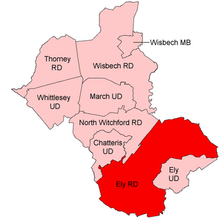
Ely was a rural district in England from 1894 to 1974. It was named after Ely, and surrounded it to the west and north. The district was created in 1894 under the Local Government Act 1894 from the Ely rural sanitary district. It formed part of the administrative county of the Isle of Ely from 1894 to 1965, when this was merged into Cambridgeshire and Isle of Ely.
The County Borough of Dudley was a local government district in the English Midlands from 1865 to 1974. Originally a municipal borough, it became a county borough in 1889, centred on the main town centre of Dudley, along with the suburbs of Netherton and Woodside. Although surrounded by Staffordshire, the borough was associated with Worcestershire for non-administrative purposes, forming an exclave of the county until 1966, when it was transferred to Staffordshire after an expansion of the borough boundaries. Following local government reorganization in 1974, Dudley took in the boroughs of Halesowen and Stourbridge to form the present-day Metropolitan Borough of Dudley, in the newly formed West Midlands county.
The Municipal Borough of Leigh was, from 1899 to 1974, a local government district of the administrative county of Lancashire, England, consisting of the townships of Pennington, Westleigh, Bedford and part of the township of Atherton and named after the ancient ecclesiastcal parish. The area contained the market town of Leigh that served as its administrative centre until its dissolution in 1974. The borough council built Leigh Town Hall which was completed in 1907.

The Municipal Borough of Farnworth was a local government district centred on the town of Farnworth in the administrative county of Greater Manchester, England. A local board of health had been established for Farnworth in 1863, which was reconstituted as an urban district in 1899, before being granted a charter of incorporation to become a municipal borough in 1939. Following abolition of the local authority in 1974, Farnworth became an unparished area of the Metropolitan Borough of Bolton in Greater Manchester.

Brierley Hill Urban District was a former Urban District in Staffordshire, England, comprising the areas of Brierley Hill, Kingswinford, Quarry Bank, and Pensnett, now within the modern-day Dudley Metropolitan Borough in the West Midlands county.
Runcorn Urban District was an urban district in Runcorn, Cheshire, England, created in 1894 and abolished in 1974. It was absorbed into the Borough of Halton.
Madron Urban District was an urban district in Cornwall, England, based on Madron. It was created in 1894 and abolished in 1934 when it was absorbed by the Municipal Borough of Penzance and West Penwith Rural District.

Thetford Rural District was a rural district in Norfolk, England from 1894 to 1935.

St Faith's and Aylsham Rural Districts were adjacent rural districts in Norfolk, England from 1894 to 1935.

Blofield and East and West Flegg Rural Districts were adjacent rural districts in Norfolk, England from 1894 to 1935.

Forehoe and Henstead Rural Districts were adjacent rural districts in Norfolk, England from 1894 to 1935.

Blything Rural District was a rural district within the administrative county of East Suffolk between 1894 and 1934. It was created out of the earlier Blything rural sanitary district.
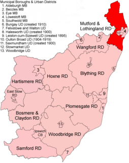
Mutford and Lothingland Rural District was a rural district within the administrative county of East Suffolk between 1894 and 1934. It was created out of the earlier Mutford and Lothingland rural sanitary district.

Plomesgate Rural District was a rural district within the administrative county of East Suffolk between 1894 and 1934. It was created out of the earlier Plomesgate rural sanitary district.

