
Grand Forks County is a county in the U.S. state of North Dakota. As of the 2010 United States Census, its population was 66,861, making it the third-most populous county in North Dakota. Its county seat and largest community is Grand Forks.

Polk County is a county in the northwestern part of the U.S. state of Minnesota. The population was 31,600 at the 2010 United States Census. Its county seat is Crookston, and the largest community is East Grand Forks.

Emerado is a city in Grand Forks County, North Dakota, United States located near Grand Forks Air Force Base. It is part of the "Grand Forks, ND-MN Metropolitan Statistical Area" or "Greater Grand Forks". The population was 414 at the 2010 census. Grand Forks Air Force Base is located near Emerado.
Larimore is a city in Grand Forks County, North Dakota, United States. It is located three miles south of the junction of U.S. Route 2 and North Dakota Highway 18. Larimore is part of the "Grand Forks, ND-MN Metropolitan Statistical Area" or "Greater Grand Forks". The population was 1,346 at the 2010 census. Larimore was founded in 1881.

Cavalier is the largest city in Pembina County, North Dakota, United States. It is the county seat of Pembina County. The population was 1,302 at the 2010 census. Cavalier was founded in 1875 and became the county seat in 1911.

Plattsburgh is an unincorporated community in central Harmony Township, Clark County, Ohio, United States. It is located along State Route 54 near the headwaters of the North Fork Little Miami River.

The Cumberland River is a major waterway of the Southern United States. The 688-mile-long (1,107 km) river drains almost 18,000 square miles (47,000 km2) of southern Kentucky and north-central Tennessee. The river flows generally west from a source in the Appalachian Mountains to its confluence with the Ohio River near Paducah, Kentucky, and the mouth of the Tennessee River. Major tributaries include the Obey, Caney Fork, Stones, and Red rivers.

Benbow Lake State Recreation Area is a state park unit of California in the United States. It is located in Humboldt County 2 miles (3.2 km) south of Garberville on U.S. Route 101 on the South Fork Eel River.

The Huron River is a 130-mile-long (210 km) river in southeastern Michigan, rising out of the Huron Swamp in Springfield Township in northern Oakland County and flowing into Lake Erie, as it forms the boundary between present-day Wayne and Monroe counties. Thirteen parks, game areas, and recreation areas are associated with the river, which passes through the cities of Dexter, Ann Arbor, Ypsilanti, Belleville, Flat Rock and Rockwood that were developed along its banks.

Lake Oroville is a reservoir formed by the Oroville Dam impounding the Feather River, located in Butte County, northern California. The lake is situated 5 miles (8.0 km) northeast of the city of Oroville, within the Lake Oroville State Recreation Area, in the western foothills of the Sierra Nevada. Known as the second-largest reservoir in California, Lake Oroville is treated as a keystone facility within the California State Water Project by storing water, providing flood control, recreation, freshwater releases assist in controlling the salinity intrusion Sacramento-San Joaquin Delta and protecting fish and wildlife.

"Greater Grand Forks" is the name used by some people to designate the twin cities of Grand Forks, North Dakota and East Grand Forks, Minnesota, together with their surrounding areas. The two cities lie directly across from each other on both sides of the Red River of the North, but Grand Forks, with a population of 52,838, is more than five times larger than East Grand Forks, with a population of 8,601. The metropolitan area includes all of the related two counties in the two states: Grand Forks County in North Dakota and Polk County in Minnesota. As of the 2010 census, the MSA had a population of 98,461, and in 2018 estimates placed the total population at 102,299.
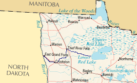
The Red Lake River is a river located in northwestern Minnesota. The river begins on the western side of the Lower Red Lake and flows westward. After passing through Thief River Falls, Red Lake Falls, and Crookston, the river merges with the Red River of the North in East Grand Forks. The total length of the river is 193 miles (310.6 km). The term "Forks" in Grand Forks comes from this forking (confluence) of the Red and Red Lake rivers near downtown Grand Forks.
The Greater Grand Forks Greenway is a huge greenway bordering the Red River and Red Lake River in the twin cities of Grand Forks, North Dakota and East Grand Forks, Minnesota. At 2,200 acres (9 km2), the Greenway is more than twice the size of New York City's Central Park. It has an extensive, 20-mile (32 km) system of bike paths, which are used by bikers, walkers, joggers, and rollerbladers. In 2007, the system was designated as a National Recreation Trail by the National Park Service.

The Turtle River is a 74.9-mile-long (120.5 km) tributary of the Red River of the North in northeastern North Dakota in the United States. It flows for almost its entire length in Grand Forks County. Via the Red River, Lake Winnipeg and the Nelson River, the Turtle River is part of the watershed of Hudson Bay.

The San Gabriel River is a river that flows through central Texas. The San Gabriel River is formed in Georgetown, Texas by the confluence of the North Fork San Gabriel and the South Fork San Gabriel, both of which originate in Burnet County. There are two major impoundments of the river: Lake Georgetown along the North Fork, and Granger Lake, about 25 miles (40 km) below the confluence. Both are U.S. Army Corps of Engineers impoundments. The San Gabriel River joins the Little River five miles south of Cameron which then meets the Brazos River northwest of College Station. There is a city park in Georgetown at the confluence of the North and South Forks, with a well-known local swimming spot located just upriver from the confluence on the South Fork.
Myra is an ancient Lycian town in modern Turkey.
John W. Ross (1848–1914) was the first licensed architect in Grand Forks, North Dakota.

Cheney Reservoir is a reservoir on the North Fork Ninnescah River in Reno, Kingman, and Sedgwick counties of Kansas in the United States. Built and managed by the U.S. Bureau of Reclamation for local water supply, it is also used for flood control and recreation. Cheney State Park is located on its shore.

Bowman-Haley Dam is an embankment dam located in Bowman County, North Dakota, in the southwestern part of the state. The dam is just over 2 miles north of the South Dakota border.

South Fork Dam is a dam in Elko County, Nevada, in the northeastern part of the state, about fifteen miles south of the town of Elko.