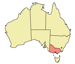
The Native Vegetation Management: A Framework for action 2002 is a Victorian strategy which aims to protect, enhance and revegetate Victoria's native vegetation. The Framework's main goal is to "achieve a reversal, across the entire landscape of the long-term decline in the extent and quality of native vegetation, leading to a net gain." . The framework is notable for the inclusion of offsets, which allow authorised land clearing, providing there is a net gain in biodiversity, and for the fact that a monetary value is being placed on biodiversity. The "habitat hectare" has been defined as the trading currency of the framework, and provides a reliable and repeatable measurement of the quality of the native vegetation when correctly administered by an experienced assessor. The trading in "habitat hectares" is a form of biodiversity banking, which occurs in the private market responding to the supply and demand of the available remnant vegetation.
The act is administered by the Victorian Department of Sustainability and Environment (DSE).
| | This environment-related article is a stub. You can help Wikipedia by expanding it. |

The Australian National Botanic Gardens (ANBG) is a heritage-listed botanical garden located in Acton, Canberra, in the Australian Capital Territory, Australia. Established in 1949, the Gardens is administered by the Australian Government's Department of Agriculture, Water and the Environment. The botanic gardens was added to the Commonwealth Heritage List on 22 June 2004.
The Flora and Fauna Guarantee Act 1988, also known as the FFG Act, is an act of the Victorian Parliament designed to protect species, genetic material and habitats, to prevent extinction and allow maximum genetic diversity within the Australian state of Victoria for perpetuity. It was the first Australian legislation to deal with such issues. It enables the listing of threatened species and communities and threats to native species, and the declaration of critical habitat necessary for the survival of native plants and animals.

The Environment Protection and Biodiversity Conservation Act 1999(Cth) is an Act of the Parliament of Australia that provides a framework for protection of the Australian environment, including its biodiversity and its natural and culturally significant places. Enacted on 17 July 2000, it established a range of processes to help protect and promote the recovery of threatened species and ecological communities, and preserve significant places from decline. The Act is as of June 2020 administered by the Department of Agriculture, Water and the Environment. Lists of threatened species are drawn up under the Act, and these lists, the primary reference to threatened species in Australia, are available online through the Species Profile and Threats Database (SPRAT).

The Cathedral Range State Park located in Victoria, Australia, approximately 100 kilometres (62 mi) north-east of Melbourne. It is situated between the towns of Buxton and Taggerty and runs parallel to the Maroondah Highway. The Cathedral Range was declared a State Park on 26 April 1979. It consists of 3,577 hectares and contains the rugged Razorback and spectacular peaks of the Cathedral Range, Little River and forested hills of the Blue Range. Due to its proximity to Melbourne the Cathedral Ranges are a popular destination for both day and weekend adventures. Bushwalking, camping, rock climbing and abseiling are some of the more popular activities available. Cathedral Range State Park is listed as Category II under the IUCN World Commission on Protected Areas and is an example of a park that can be used for recreation, education and conserving natural ecosystems.
Natural resource management (NRM) is the management of natural resources such as land, water, soil, plants and animals, with a particular focus on how management affects the quality of life for both present and future generations (stewardship).

The Avon Wheatbelt is a bioregion in Western Australia. It has an area of 9,517,104 hectares. It is considered part of the larger Southwest Australia savanna ecoregion.

Lewin's rail is a species of bird in the family Rallidae. It is also known as the water rail, Lewin's water rail, Lewin's grind rail, slate-breasted rail, slate-breasted water rail, pectoral rail, pectoral water rail, short-toed rail and short-toed water rail.

The rufous bristlebird is one of three extant species of bristlebirds. It is endemic to Australia where three subspecies have been described from coastal southwestern Western Australia, southeastern South Australia and southwestern Victoria. Its natural habitat is coastal shrublands and heathlands. It is threatened by habitat destruction.

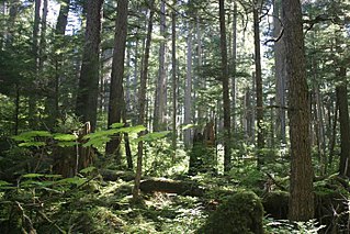
Land clearing in Australia describes the removal of native vegetation and deforestation in Australia. Land clearing involves the removal of native vegetation and habitats, including the bulldozing of native bushlands, forests, savannah, woodlands and native grasslands and the draining of natural wetlands for replacement with agriculture, urban and other land uses.
Biodiversity banking, also known as biodiversity trading or conservation banking, biodiversity mitigation banks, compensatory habitat, set-asides, biodiversity offsets, are conservation activities that compensate for the loss of biodiversity with the goal of biodiversity maintenance through a framework which allows biodiversity to be reliably measured, and market based solutions applied to improving biodiversity. Biodiversity banking provides a means to place a monetary value on ecosystem services. Typically this involves land protection, restoration, an/or enhancement. Biodiversity banking is often applied so that there is no "net loss of a particular biodiversity feature." According to the International Union for Conservation of Nature, by 2004, interest in voluntary biodiversity offsets was growing in the United States, Brazil, Australia, Canada and the EU. Experience suggested that industry, governments, local communities and conservation groups all benefit from biodiversity offsets or biodiversity banking.

Established in 1965, the Yellingbo Nature Conservation Reserve is located 45 km east of Melbourne in the Upper Yarra Valley, near the towns of Yellingbo, Launching Place, Yarra Junction, Hoddles Creek, Cockatoo, Emerald, Monbulk and Seville. Yellingbo Nature Conservation Reserve is a narrow riparian reserve with stream-frontage land along the Woori Yallock, Shepherd, Cockatoo, Macclesfield and Sheep Station Creeks.

Conservation in India can be traced to the time of Ashoka, tracing to the Ashoka Pillar Edicts as one of the earliest conservation efforts in the world. Conservation generally refers to the act of carefully and efficiently using natural resources. Conservation efforts begun in India before 5 AD, as efforts are made to have a forest administration. The Ministry of Environment, Forest and Climate Change is the ministry responsible for implementation of environmental and forestry program in India, which include the management of national parks, conservation of flora and fauna of India, and pollution controls.
The Warby-Ovens National Park is a national park located on the lands of the Bangerang clan of the Yorta Yorta Nation in the Hume region of Victoria, Australia near Killawara. The 14,655-hectare (36,210-acre) national park is situated approximately 10 kilometres (6.2 mi) west of Wangaratta and 240 kilometres (150 mi) northeast of Melbourne.
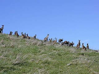
A sustainable wildlife enterprise is a farming system that incorporates sustainable use of wildlife to promote conservation. In Australia, landholders work together across boundaries to sustainably harvest or make use of (ecotourism) naturally occurring wildlife populations such as the kangaroo. Important to the concept is that biodiversity and environmental benefit occurs via alternative land uses. Attaching a value to native resources through commercial development has the potential to provide alternative sources of income, especially in areas where traditional systems are no longer as profitable or environmentally sustainable. The Sustainable Wildlife Enterprise system enables farmers to realise the financial value of native wildlife such as the kangaroo and encourages them to manage their land that supports the source of the income without lowering total farm profitability – hence contributing to habitat and biodiversity conservation. The Sustainable Wildlife Enterprise system has been developed in Australia but is based on world-wide experiences.
Land for Wildlife is a program sponsored by the Department of Sustainability and Environment in the state of Victoria, Australia. It was established in November 1981 to support private landholders and managers who voluntarily provide and enhance habitat for native wildlife on their properties within the state. Many non-landholder volunteers also participate in the scheme, which is coordinated by departmental extension officers. By doing so they are contributing to the maintenance and restoration of native biodiversity. The scheme was largely instigated by Ellen McCulloch and Reg Johnson, two prominent members of the community group Bird Observation & Conservation Australia, with which it continues to have a cooperative relationship.
Roadside conservation is a conservation strategy in Australia and other countries where Road verge flora and habitats are protected or improved. The general aim is to conserve or increase the amount of native flora species; especially where that work will lead to higher conservation value, for example providing food or habitat for rare or endangered native fauna.
Trust for Nature is a not-for-profit organisation in the Australian state of Victoria which protects native plants and wildlife in co-operation with private landowners. The Trust was established under the Victorian Conservation Trust Act 1972 to enable people to contribute permanently to nature conservation by donating land or money. Trust for Nature has since evolved into one of Victoria's primary private land conservation organisations.
The Point Cook Coastal Park covers an area of 863 hectares and includes the Cheetham Wetlands. The park extends from the RAAF Williams Point Cook Base northeast along the coast to the Laverton creek which comprises its northern boundary. The park is approximately 20 kilometres (12 mi) from Melbourne, Australia in a southwesterly direction along Port Phillip Bay. The park is adjoined by the Point Cook Marine Sanctuary, which extends around the point to the south and the east. The northwestern boundary to the park is residential housing.

King is an interim Australian bioregion which includes King Island, the Hunter Islands, Robbins Island, and the north-western tip of Tasmania. The bioregion covers 425,567 hectares.

The land area of Victoria, Australia is estimated to have had 88% forest coverage totaling 199,830 km2 in 1869 during early European colonisation of Victoria. This was at a time between the 1861 and 1871 censuses of the colony of Victoria in which the number of inhabitants of the colony were estimated to number between 540,322 (1861) and 729,654 (1871), and the number of houses were estimated to number between 134,332 (1861) and 160,410 (1871). By 1987, deforestation had led to the forested areas of Victoria declining to 35% (79,656 km2) of the total land area.