
Windsor is a historic town north-west of Sydney, New South Wales, Australia. It is in the Hawkesbury local government area. The town sits on the Hawkesbury River, enveloped by farmland and Australian bush. Many of the oldest surviving European buildings in Australia are located at Windsor. It is 46 kilometres (29 mi) north-west of metropolitan Sydney, on the fringes of urban sprawl.

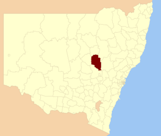
Towamba is a small community, in New South Wales, Australia in Bega Valley Shire. It is located about forty minutes' drive west of Eden. At the 2016 census, Towamba had a population of 234 people.

Wollondilly Shire is a periurban local government area adjacent to the south-western fringe of Sydney, parts of which fall into the Macarthur, Blue Mountains and Central Tablelands regions in the state of New South Wales, Australia.

Grafton Bridge is a heritage-listed bascule bridge which spans the Clarence River in Grafton, New South Wales, Australia. It links the CBD with South Grafton, and carries the North Coast railway line. It was added to the New South Wales State Heritage Register on 2 April 1999.

Barham is a town in the western Riverina district of New South Wales, Australia. The town is located 823 kilometres south west of the state capital, Sydney and 303 kilometres north west of Melbourne. Situated on the banks of the Murray River across from Koondrook in the neighbouring state of Victoria, Barham had a population of 1,159 at the 2016 census. The town is in the Murray River Council local government area.

The City of Lithgow is a local government area in the Central West region of New South Wales, Australia. The area is located adjacent to the Great Western Highway and the Main Western railway line.

Hinton is a suburb of the Port Stephens local government area in the Hunter Region of New South Wales, Australia. Primarily rural, the largest population centre is the township of Hinton, which is situated on the Paterson River, near to the confluence of the Hunter and Paterson rivers.

Bundarra is a small town on the Northern Tablelands of New South Wales, Australia. The town is located on Thunderbolts Way and on the banks of the Gwydir River, in the Uralla Shire local government area, 563 kilometres (350 mi) from the state capital, Sydney. At the 2016 census, Bundarra had a population of 394 and the surrounding area had 676 persons.
The Nullica River is an intermittently closed semi-mature saline coastal lagoon or perennial river, located in the South Coast region of New South Wales, Australia.
The Towamba River is an open mature wave dominated barrier estuary or perennial river, located in the South Coast region of New South Wales, Australia.

The Wallagaraugh River is a perennial river of the Genoa River catchment, with its headwaters located in the South Coast region of New South Wales and its lower reaches located in the East Gippsland region of Victoria, Australia.
The Wog Wog River is a perennial river of the Towamba River catchment, located in the South Coast region of New South Wales, Australia.
Yowaka River, a perennial river of the Pambula River catchment, is located in the South Coast region of New South Wales, Australia.

The Snowy Monaro Regional Council is a local government area located in the Snowy Mountains and Monaro regions of New South Wales, Australia. The council was formed on 12 May 2016 through a merger of the Bombala, Cooma-Monaro and Snowy River shires.

The Murray River Council is a local government area in the Riverina region of New South Wales, Australia. This area was formed in 2016 from the merger of Murray Shire with Wakool Shire.
The Dubbo Regional Council is a local government area located in the Central West and Orana regions of New South Wales, Australia. The council was formed on 12 May 2016 through a merger of the City of Dubbo and Wellington Council. Originally named Western Plains Regional Council, the name was changed to Dubbo Regional Council on 7 September 2016.
Murray Downs is a locality in the Murray River Council, New South Wales, Australia.
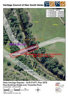
The Towamba River bridge is a heritage-listed road bridge across the Towamba River at New Buildings in the Bega Valley Shire local government area of New South Wales, Australia. The property is owned by Roads and Maritime Services, an agency of the Government of New South Wales. The bridge is also called the New Buildings Bridge over Towamba River. It was added to the New South Wales State Heritage Register on 20 June 2000.

The Parramatta River railway bridge is a heritage-listed former railway bridge and now cycleway which carried the Main Northern line across the Parramatta River between the suburbs of Meadowbank and Rhodes in the City of Canada Bay local government area of New South Wales, Sydney, Australia. The railway bridge was designed by John Whitton and built in 1886. The bridge is also known as the Meadowbank Rail Bridge over Parramatta River, the John Whitton Bridge and the Meadowbank-Rhodes Railway Bridge. The property is owned by RailCorp, an agency of the Government of New South Wales. It was added to the New South Wales State Heritage Register on 2 April 1999.
Mount George is a locality in the Mid-Coast Council of New South Wales. It had a population of 288 as of the 2016 census.


