The French and Indian Wars were a series of conflicts that occurred in North America between 1688 and 1763, some of which indirectly were related to the European dynastic wars. The title French and Indian War in the singular is used in the United States specifically for the warfare of 1754–63, which composed the North American theatre of the Seven Years' War and the aftermath of which led to the American Revolution. The French and Indian Wars were preceded by the Beaver Wars.

The Northwest Territory, also known as the Old Northwest and formally known as the Territory Northwest of the River Ohio, was formed from unorganized western territory of the United States after the American Revolutionary War. Established in 1787 by the Congress of the Confederation through the Northwest Ordinance, it was the nation's first post-colonial organized incorporated territory.
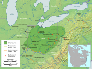
The Ohio Country, was a name used before 1787 for a region of North America west of the Appalachian Mountains, north of the upper Ohio and Allegheny rivers, and extending to Lake Erie. The area roughly encompassed present-day northwestern West Virginia, Western Pennsylvania, most of Ohio, and a wedge of southeastern Indiana.
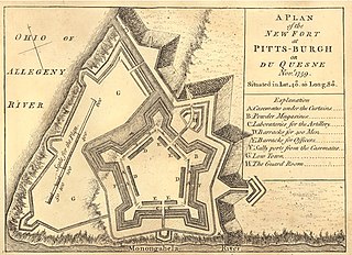
Fort Pitt was a fort built by British forces between 1759 and 1761 during the French and Indian War at the confluence of the Monongahela and Allegheny rivers, where the Ohio River is formed in western Pennsylvania. It was near the site of Fort Duquesne, a French colonial fort built in 1754 as tensions increased between Great Britain and France in both Europe and North America. The French destroyed Fort Duquesne in 1758 when they retreated under British attack.

Dummer's War (1722–1725) is also known as Father Rale's War, Lovewell's War, Greylock's War, the Three Years War, the Wabanaki-New England War, or the Fourth Anglo-Abenaki War. It was a series of battles between the New England Colonies and the Wabanaki Confederacy, who were allied with New France. The eastern theater of the war was located primarily along the border between New England and Acadia in Maine, as well as in Nova Scotia; the western theater was located in northern Massachusetts and Vermont at the border between Canada and New England. During this time, Maine and Vermont were part of Massachusetts.
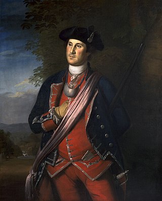
William Trent was an American fur trader and merchant based in colonial Pennsylvania. He was commissioned as a captain of the Virginia Regiment in the early stages of the French and Indian War, when he served on the western frontier with the young Lt. Colonel George Washington. Trent led an advance group who built forts and improved roads for troop access and defense of the western territory. He was later promoted to the rank of major.
Fort Bedford was a French and Indian War-era British military fortification located at the present site of Bedford, Pennsylvania. The fort was a star-shaped log fortress erected in the summer of 1758.
The 1st New Jersey Regiment was the first organized militia regiment in New Jersey, formed in 1673 in Piscataway "to repel foreign Indians who come down from upper Pennsylvania and western New York to our shores and fill (themselves) with fishes and clams and on the way back make a general nuisance of themselves by burning hay stacks, corn fodder and even barns." The first commander and founder of the regiment was Captain Francis Drake (1615-1687) who served from 1673 to 1685. All of New Jersey's regular organized military forces trace their lineage to this first provincial militia unit.

Fort Presque Isle was a fort built by French soldiers in summer 1753 along Presque Isle Bay at present-day Erie, Pennsylvania, to protect the northern terminus of the Venango Path. It was the first of the French posts built in the Ohio Country, and was part of a line that included Fort Le Boeuf, Fort Machault, and Fort Duquesne.
The Military Road was a roadway built in the present-day U.S. state of New Jersey during the French and Indian War connecting Elizabethtown with a string of fortifications along the Delaware River in modern Sussex and Warren Counties in northwestern New Jersey. The road was conceived and built under the order of Jonathan Hampton, Esq., an Elizabethtown merchant and surveyor who was appointed as Victualer and Paymaster to the New Jersey Frontier Guard by an act of the New Jersey's colonial legislature.

Fort Halifax is a former British colonial outpost on the banks of the Sebasticook River, just above its mouth at the Kennebec River, in Winslow, Maine. Originally built as a wooden palisaded fort in 1754, during the French and Indian War, only a single blockhouse survives. The oldest blockhouse in the United States, it is preserved as Fort Halifax State Historic Site, and is open to the public in the warmer months. The fort guarded Wabanaki canoe routes that reached to the St. Lawrence and Penobscot Valleys via the Chaudière-Kennebec and Sebasticook-Souadabscook rivers. The blockhouse was declared a National Historic Landmark and added to the National Register of Historic Places in 1968.

Light's Fort was built in 1742 by Johannes Peter Leicht [John Light] (1682-1758). Light's Fort is the oldest standing building of any kind in the county and city of Lebanon, Pennsylvania. John Light, an immigrant, purchased the land on December 29, 1738, from Caspar Wistar, and wife, Katherine, of the City of Philadelphia, Brass Button Maker, for 82 pounds and 4 shillings. Light's Fort was built in 1742 on a tract of land, which was situated on a branch of the Quittapahilla Creek in Lancaster County at North 11th and Maple Streets. It contained 274 acres including an allowance of 6% for roads together with woods, water courses, etc.

The northern theater of the American Revolutionary War after Saratoga consisted of a series of battles between American revolutionaries and British forces, from 1778 to 1782 during the American Revolutionary War. It is characterized by two primary areas of activity. The first set of activities was based around the British base of operations in New York City, where each side made probes and counterprobes against the other's positions that sometimes resulted in notable actions. The second was essentially a frontier war in Upstate New York and rural northern Pennsylvania that was largely fought by state militia companies and some Indian allies on the American side, and Loyalist companies supported by Indians, British Indian agents, and occasionally British regulars. The notable exception to significant Continental Army participation on the frontier was the 1779 Sullivan Expedition, in which General John Sullivan led an army expedition that drove the Iroquois out of New York. The warfare amongst the splinters of the Iroquois Six Nations were particularly brutal, turning much of the Indian population into refugees.

General Hugh Waddell was an Irish-born American military officer in the Province of North Carolina prior to the American Revolutionary War. Waddell formed and led a provincial militia unit in Rowan County, North Carolina and the Ohio River Valley during the French and Indian War and the Anglo-Cherokee War, and supervised the construction of Fort Dobbs near the settlement of the Fourth Creek Congregation. His career was well-served by close connections to several provincial governors of North Carolina.
Colonial American military history is the military record of the Thirteen Colonies from their founding to the American Revolution in 1775.

Fort Dobbs was an 18th-century fort in the Yadkin–Pee Dee River Basin region of the Province of North Carolina, near what is now Statesville in Iredell County. Used for frontier defense during and after the French and Indian War, the fort was built to protect the American settlers of the western portion of what was then Rowan County, and served as a vital outpost for soldiers, traders, and colonial officials. Fort Dobbs' primary structure was a blockhouse with log walls, surrounded by a shallow ditch, and by 1761, a palisade. It was intended to provide protection from French-allied Native Americans such as the Shawnee and Delaware, and French raids into North Carolina.

Van Campen's Inn or Isaac Van Campen Inn is a fieldstone residence that was used as a yaugh house during the American colonial era. Located in Walpack Township, Sussex County, New Jersey along the Delaware River, it is a historic site located along the Old Mine Road in the Delaware Water Gap National Recreation Area. It is operated under a memorandum of understanding between the National Park Service and the Walpack Historical Society, a local non-profit corporation.
Jonathan Hampton was an American colonial surveyor, merchant, and militia officer involved with New Jersey's frontier fortifications and defenses along the Delaware River during the French and Indian War (1755-1763).

Provincial troops were military units raised by colonial governors and legislatures in British North America for extended operations during the French and Indian Wars. The provincial troops differed from the militia, in that they were a full-time military organization conducting extended operations. They differed from the regular British Army in that they were recruited only for one campaign season at the time. These forces were often recruited through a quota system applied to the militia. Officers were appointed by the provincial governments. During the eighteenth century militia service was increasingly seen as a prerogative of the social and economic well-established, while provincial troops came to be recruited from different and less deep-rooted members of the community.

In 1755, during the French and Indian War, marauding Indians allied with the French attacked European settlers along the Blue Mountains of Pennsylvania. Several of these attacks occurred near the Swatara Gap area. Peter Hedrick and other Swatara Gap area settlers fortified Hedrick's farmstead by building a log-walled stockade around the structure. This was the beginning of Fort Swatara. On January 25, 1756, Captain Frederick Smith and a company of 50 militiamen received orders from Robert Hunter Morris, deputy governor of Colonial Pennsylvania, to take posts at Swatara Gap. Capt. Smith's orders were to occupy the existing fortification at Hedrick's farmstead and reinforce it if necessary. Smith's troops erected a military-style log blockhouse and magazine shed for ammunition storage and surrounded the structures with a sturdy log stockade.