The Tuapeka River is a river located in Otago in the South Island of New Zealand. It is a tributary of the Clutha River, which it joins at Tuapeka Mouth between Roxburgh and Balclutha.

Rufiji is one of the six districts of the Pwani Region of Tanzania. It is bordered to the north by the Kisarawe and Mkuranga Districts, to the east by the Indian Ocean, to the south by the Kilwa District, Lindi Region and to the west by the Morogoro Region. The district capital is the town of Utete on the southern banks of the Rufiji River.

Morogoro is a city located in the eastern part of Tanzania, approximately 196 kilometers west of Dar es Salaam. It serves as the capital of the Morogoro Region. Informally, it is referred to as Mji kasoro bahari, which translates to city short of an ocean/port.

Morogoro Region is one of Tanzania's 31 administrative regions. The region covers an area of 70,624 km2 (27,268 sq mi). The region is comparable in size to the combined land area of the nation state of Ireland. Morogoro Region is bordered to the north by the Manyara Region and Tanga Region, to the east by the Pwani and Lindi Regions, to the south by the Ruvuma Region and to the west by the Iringa Njombe and Dodoma Regions. The regional capital is the municipality of Morogoro. According to the 2012 national census, the region had a population of 2,218,492.

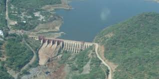
Kidatu Dam, also Kidadu Hydroelectric Power Station, is a 204 megawatts (274,000 hp) hydroelectric dam located in Kilosa District of Morogoro Region in Tanzania.

The Great Ruaha River is a river in south-central Tanzania that flows through the Usangu wetlands and the Ruaha National Park east into the Rufiji River. It traverses and marks the borders between Iringa Region, Dodoma Region and Morogoro Region. The Great Ruaha river has a basin catchment area of 83,970 square kilometres (32,421 sq mi). The population of the basin is mainly sustained by irrigation and water-related livelihoods such as fishing and livestock keeping.

The Musa is a river on the eastern side of the Papuan Peninsula, in Papua New Guinea. It is one of the primary rivers on Oro Province. Its mouth exits into Dyke Ackland Bay.

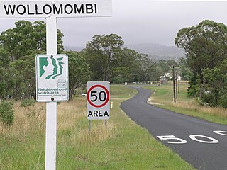
Wollomombi is a small village situated 1 km north of Waterfall Way and approximately 38 kilometres east of Armidale, New South Wales, Australia. The settlement is at an altitude of about 964 metres on the Northern Tablelands in the New England region.
Cells River, a perennial river of the Manning River catchment, is located in the Northern Tablelands and Mid North Coast districts of New South Wales, Australia.
The Wog Wog River is a perennial river of the Towamba River catchment, located in the South Coast region of New South Wales, Australia.

The Mangatāwhiri River is a river of the Waikato region of New Zealand's North Island. It flows generally southwest from its sources in the Hunua Ranges southeast of Clevedon before flowing through a system of irrigation canals at the northern edge of the Waikato Plains close to the town of Pōkeno. It reaches the Waikato River close to the township of Mercer.

Guapirama is a municipality in the state of Paraná in the Southern Region of Brazil.

Ngerengere is a Tanzanian ward of Morogoro District in Morogoro Region. It is located south of the A7 trunk road that connects Dar es Salaam to Morogoro. It is named after the Ngerengere River. The Tanzanian Army's air force command maintains an airbase near the vicinity.

Hektoria Glacier is a glacier flowing south from the area around Mount Johnston between Mount Quandary and Zagreus Ridge into Vaughan Inlet next west of Brenitsa Glacier and east of Green Glacier, on the east coast of the Antarctic Peninsula.

Sal Glacier is a glacier, 7 nmi long, flowing north between Salen Mountain and Mount Bergersen in the Sor Rondane Mountains. Mapped by Norwegian cartographers in 1957 from air photos taken by U.S. Navy Operation Highjump, 1946–47, and named Salbreen, probably for its association with Salen Mountain.

Morogoro Airstrip is an airstrip serving the city of Morogoro in the Morogoro Region of Tanzania. It is 3.5 kilometres (2.2 mi) north of the town. The airstrip location is just off the western side of the prohibited airspace (HTP6) of the Ngerengere Air Force Base but lies within the restricted airspace (HTR7).
Ngerengere Air Force Base is a military airbase of the Tanzania Air Force Command. It is located about 120 kilometres (75 mi) west of Dar es Salaam, in Ngerengere ward, Morogoro District of Morogoro Region in Tanzania.

The Ruvu River is a river in eastern Tanzania.
This page is based on this
Wikipedia article Text is available under the
CC BY-SA 4.0 license; additional terms may apply.
Images, videos and audio are available under their respective licenses.


