
Pu'er is a prefecture-level city in southern Yunnan Province,China. The urban administrative center of Pu'er is Simao District,which is also the former name of the prefecture-level city itself. A major downturn in the price of tea in 2007 caused severe economic distress in the area. The price of Pu'er has since recovered and Pu'er tea still contributes much to the income of the area.

Lancang Lahu Autonomous County is an autonomous county under the jurisdiction of Pu'er City,in southwestern Yunnan province,China. Lancang is the same as Lan Xang,and refers to the Mekong River on its eastern borders and adopted by modern Laos,a Tai word meaning Million Elephants.

Luquan Yi and Miao Autonomous County is an autonomous county,under the jurisdiction of Kunming,Yunnan,China,bordering Sichuan province to the north. As of the 2020 census the population was 378,881.

Simao District is a district under the jurisdiction of Pu'er City,Yunnan Province,China. It is the seat of Pu'er Prefecture. Formerly both Simao and the surrounding region of Pu'er prefecture played a major role in the historic tea horse trade between Yunnan,Tibet and India,with Simao acting as the southern terminus or starting point for the transport of tea by mule caravan north to Dali,Lijiang and Lhasa. Tea remains a central crop and product of the region.

Jiangcheng Hani and Yi Autonomous County is an autonomous county under the jurisdiction of Pu'er City,in southern Yunnan,China,bordering Laos and Vietnam to the south,making it the only county in the province to border more than one country. By road,its seat,the town of Menglie (勐烈镇),is 520 km (320 mi) from Kunming and 145 km (90 mi) from Simao District,the municipal seat of Pu'er.

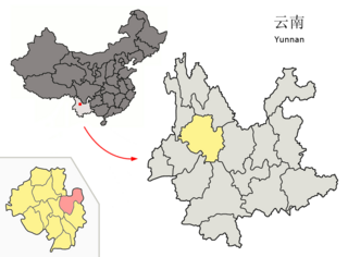
Jingdong Yi Autonomous County is an autonomous county in the west-central part of Yunnan Province,China. It is the northernmost county-level division of the prefecture-level city of Pu'er.

Jinggu Dai and Yi Autonomous County is an autonomous county under the jurisdiction of Pu'er City,Yunnan Province,China.

Menglian Dai,Lahu and Va Autonomous County is an autonomous county in the southwest of Yunnan Province,China,bordering Ximeng County to the north,Lancang County to the north,northeast,and east,and Burma's Shan State to the south and west. It is the westernmost county-level division of Pu'er City
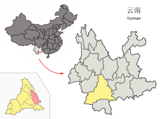
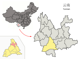
Mojiang Hani Autonomous County is an autonomous county under the jurisdiction of Pu'er City,in the south of Yunnan Province,China.

Ximeng Va Autonomous County is an autonomous county under the jurisdiction of Pu'er City,in the southwest of Yunnan Province,China,bordering Myanmar's Shan State to the west. Wa/Va people,who speak the Wa language,are the main inhabitants in Ximeng County.
Zhenyuan Yi,Hani and Lahu Autonomous County is an autonomous county under the jurisdiction of Pu'er City,in the west central part of Yunnan Province,China.

Luoping County is located in Qujing City,in eastern Yunnan province,China,bordering Guizhou province to the east and the Guangxi Zhuang Autonomous Region to the southeast.

Eshan Yi Autonomous County is located in Yuxi,in the central part of Yunnan Province,China.
Binchuan County is a county in the Dali Bai Autonomous Prefecture located in the west of Yunnan Province,China.

Heqing County is a county in the Dali Bai Autonomous Prefecture located in the northwest of Yunnan Province,China.

Xiangyun County is a county in the Dali Bai Autonomous Prefecture located in the west-central part of Yunnan province,China.

Yongping County is a county of the Dali Bai Autonomous Prefecture,located in the west of Yunnan Province,China.
Lüchun County is located in Honghe Hani and Yi Autonomous Prefecture,in the south of Yunnan province,China,bordering Vietnam's Lai Châu Province to the south.

Menghai County is a county under the jurisdiction of Xishuangbanna Dai Autonomous Prefecture,in the far south of Yunnan,China,bordering Burma's Shan State to the southwest. Meng is as variation of Mueang.

Pingshan County is a county located in southern Sichuan Province,China,bordering Yunnan province to the south. It is under the administration of Yibin city. It is on the route of China National Highway 213 and Sichuan Provincial Highway 307. As of 2012,there are 131 primary schools and 22 secondary schools in the county. There are 17 hospitals and clinics in the county. The county oversees eight towns and seven townships.


