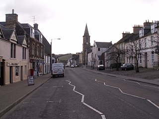
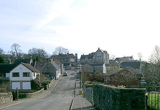
Newburgh is a royal burgh and parish in Fife, Scotland, at the south shore of the Firth of Tay. The town has a population of 2,171, which constitutes a 10% increase since 1901 when the population was counted at 1,904 persons.

The Ochil Hills is a range of hills in Scotland north of the Forth valley bordered by the cities of Stirling, Perth and the towns of Alloa, Kinross, and Auchterarder. The only major roads crossing the hills pass through Glen Devon/Glen Eagles and Glenfarg, the latter now largely replaced except for local traffic by the M90 Edinburgh-Perth motorway cutting through the eastern foothills. The hills are part of a Devonian lava extrusion whose appearance today is largely due to the Ochil Fault which results in the southern face of the hills forming an escarpment. The plateau is undulating with no prominent peak, the highest point being Ben Cleuch at 721 m (2,365 ft). The south-flowing burns have cut deep ravines including Dollar Glen, Silver Glen and Alva Glen, often only passable with the aid of wooden walkways.

Binsey is a hill on the northern edge of the Lake District in Cumbria, England. It is detached from the rest of the Lakeland hills, and thus provides a good spot to look out at the Northern and North Western Fells of the Lake District, as well as the coastal plain and, across the Solway Firth, Scotland. Snaefell on the Isle of Man is also visible on a clear day. It is the northernmost of the Wainwrights.
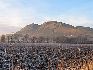
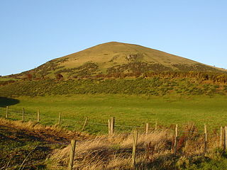
Dumyat or Dunmyat is a hill at the western extremity of the Ochil Hills in central Scotland. The name is thought to originate from Dunof the Maeatae.
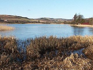
Lindores is a small village in Fife, Scotland, in the parish of Abdie, about 2 miles south-east of Newburgh. It is situated on the north-east shore of Lindores Loch, a 44 ha freshwater loch. A possible derivation of the name Lindores is 'church by the water'. The ruins of Abdie church, about 0.5 miles south-west of the village are possibly the site of an ancient shrine connected to the Celtic foundation at Abernethy. After the foundation of Lindores Abbey in 1191 the church was given to the abbey.

Markinch is both a village and a parish in the heart of Fife, Scotland. According to an estimate taken in 2008, the village has a population of 2,420. The civil parish had a population of 16,530. Markinch is east of Fife's administrative centre, Glenrothes, and preceded Cupar as Fife's place of warranty and justice prior to the 13th century.
Upper Largo or Kirkton of Largo is a village in the parish of Largo, near the East Neuk of Fife, Scotland. It rests on the southern slopes of Largo Law, half a mile north of Largo Bay and the rather larger village of Lower Largo. It is the home of Largo Cricket Club.
Saline is a village and parish in Fife, Scotland, situated 5 miles (8.0 km) to the north-west of Dunfermline. It lies in an elevated position on the western slopes of the Cleish Hills.

The Lomond Hills, also known outside the locality as the Paps of Fife, are a range of hills in central Scotland. They lie in western central Fife and Perth and Kinross, Scotland. At 522 metres (1,713 ft) West Lomond is the highest point in the county of Fife.

West Lomond is the highest point in the county of Fife, Scotland and the highest peak in the Lomond Hills. Its cone-shaped summit, which is the remains of a volcanic plug, rises above an escarpment of Carboniferous sandstone and limestone layers, capped with a quartz-microgabbro sill. The conspicuous peaks of West Lomond, and its neighbour East Lomond, are visible for many miles around, which explains one suggested origin of their name, the 'Lomond' or 'beacon' hills. On the summit are the remains of an Iron Age hill fort.

Kemback is a village and parish in Fife, Scotland, located 2.5 miles (4.0 km) east of Cupar. The present village was developed in the 19th century to house those working the flax mills on the nearby Ceres Burn. From 1681 the minister for the parish was Alexander Edward, until 1689 when he was deprived as a non-juror. He went on to become an architect and landscape architect, working on schemes for Brechin Castle and Hamilton Palace.

Charlestown is a village in Fife, Scotland. It lies on the north shore of the Firth of Forth, around 1 mile (1.6 km) west of Limekilns and 3 miles (5 km) south-west of Dunfermline. The village is known for its historic 18th century lime kilns and its Georgian planned housing.
The Newburgh and North Fife Railway was a Scottish railway company formed to build a connecting line between St Fort and Newburgh, in Fife, intended to open up residential traffic between the intermediate communities and Dundee and Perth. It opened its line, which was expensive to construct, in 1909 but the local traffic never developed. It closed to passenger traffic in 1951, and completely in 1964.

Hillend is a small village in Fife, Scotland, to the east of Inverkeithing and to the west of Dalgety Bay.

Benarty Hill, locally simply Benarty, rises above and to the west of Ballingry, in the west of Fife, Scotland. The summit ridge forms the boundary with Perth and Kinross. It is a prominent feature of the view from the M90 motorway, and from Kinross and Loch Leven. The lower slopes are steep on all sides, but the extensive heath around the summit is relatively flat.

Portmoak is a parish in Kinross-shire, Scotland. It consists of a group of settlements running north to south: Glenlomond, Wester Balgedie, Easter Balgedie, Kinnesswood, Kilmagadwood and Scotlandwell.

Luthrie is a village in the parish of Creich in Fife, Scotland. A small stream shown on maps as Windygates Burn flows through the village and occasionally floods.
Largo is a parish in Fife, Scotland containing the villages of Upper Largo or Kirkton of Largo, Lower Largo and Lundin Links. It is bounded on the west by the parish of Scoonie, on the north by Ceres and on the east by the parishes of Newburn and Kilconquhar. It has a coastline of 2¾ miles along Largo bay. Inland it extends 3-4 ½ miles north from the south coast of Fife. Area 7,378 acres.

Raith, as an area of Fife, once stretched from the lands of Little Raith, south of Loch Gelly, as far as Kirkcaldy and the Battle of Raith was once theorised to have been fought here in 596 AD. Raith Hill, west of Auchtertool and immediately to the east of the Mossmorran fractionation plant, may also be in reference to this wider area or may refer to an actual fort on this hill, distinct to the one naming the area.
Dunnicaer, or Dun-na-caer, is a precipitous sea stack just off the coast of Aberdeenshire, Scotland, between Dunnottar Castle and Stonehaven. Despite the unusual difficulty of access, in 1832 Pictish symbol stones were found on the summit and 21st-century archaeology has discovered evidence of a Pictish hill fort which may have incorporated the stones in its structure. The stones may have been incised in the third or fourth centuries AD but this goes against the general archaeological view that the simplest and earliest symbol stones date from the fifth or even seventh century AD.

