U.S. Route 701 is an auxiliary route of US 1 in the U.S. states of South Carolina and North Carolina. The U.S. Highway runs 171.45 miles (275.92 km) from US 17 and US 17 Alternate in Georgetown, South Carolina north to US 301, North Carolina Highway 96, and Interstate 95 (I-95) near Four Oaks, North Carolina. US 701 serves the Pee Dee region of South Carolina and the southern and central portions of Eastern North Carolina. The highway connects Georgetown and Conway in South Carolina with the North Carolina cities of Whiteville, Elizabethtown, Clinton, and a short distance north of its terminus, Smithfield. US 701 has four business routes in North Carolina, including those through Tabor City, Whiteville, Clarkton, and Clinton.
U.S. Route 123 is a spur of US 23 in the U.S. states of Georgia and South Carolina. The U.S. Highway runs 75.12 miles (120.89 km) from US 23, US 441, and SR 365 near Clarkesville, Georgia, north and east to Interstate 385 Business in Greenville, South Carolina. US 123 parallels I-85 to the north as it connects the Northeast Georgia cities of Clarkesville and Toccoa with the western Upstate South Carolina communities of Westminster, Seneca, Clemson, Easley, and Greenville.

U.S. Route 258 is a spur of US 58 in the U.S. states of North Carolina and Virginia. The U.S. Highway runs 220.15 miles (354.30 km) from US 17 Business and NC 24 Business in Jacksonville, North Carolina north to Virginia State Route 143 at Fort Monroe in Hampton, Virginia. In North Carolina, US 258 connects Jacksonville with the Inner Banks communities of Kinston, Snow Hill, Farmville, Tarboro, and Murfreesboro. The U.S. Highway continues through the Virginia city of Franklin, where the highway intersects US 58, and the town of Smithfield on its way to the Hampton Roads metropolitan area. US 258 crosses the James River on the James River Bridge and follows Mercury Boulevard through Newport News and Hampton.

U.S. Route 378 is a spur of US 78 in the U.S. states of Georgia and South Carolina. The U.S. Highway runs 234.30 miles (377.07 km) from US 78, Georgia State Route 10, SR 17, and SR 47 in Washington, Georgia, east to US 501 Business in Conway, South Carolina. US 378 connects the Central Savannah River Area in both states with the Midlands and Pee Dee regions of South Carolina. The U.S. Highway's western portion, which connects Washington and Lincolnton in Georgia and McCormick, Saluda, and Lexington in South Carolina, is mainly a rural highway. US 378 is a major suburban and urban highway through Lexington and the South Carolina state capital, Columbia. The highway has a lengthy concurrency with US 76 between Columbia and Sumter and serves as a major route between the Midlands and the Myrtle Beach area, between which the highway has a business route through Lake City.
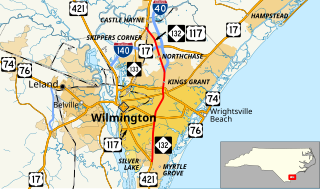
North Carolina Highway 132 (NC 132) is a North Carolina state highway entirely in New Hanover County. It travels from US 421 north of Carolina Beach through Wilmington to US 117/NC 133 just south of the main business district of Castle Hayne. The road runs just to the east of downtown Wilmington, and runs along the western edge of the University of North Carolina Wilmington.

North Carolina Highway 24 (NC 24) is the longest primary state highway in the U.S. state of North Carolina. Traveling east–west between the Charlotte metropolitan area and the Crystal Coast, connecting the cities of Charlotte, Fayetteville, Jacksonville and Morehead City.

North Carolina Highway 160 is a primary state highway in the U.S. state of North Carolina. The highway runs north–south, connecting the Steele Creek neighborhood of Charlotte, Charlotte Douglas International Airport, and Uptown Charlotte.

North Carolina Highway 16 (NC 16) is a primary state highway in the U.S. state of North Carolina. Traveling north–south, it connects the cities of Charlotte, Conover, Taylorsville, Wilkesboro and Jefferson; linking the Charlotte metropolitan area with the High Country.

North Carolina Highway 150 (NC 150) is a primary state highway in the U.S. state of North Carolina. It serves the Foothills and Piedmont Triad areas of the state, connecting the cities of Shelby, Mooresville, Salisbury and Winston-Salem.

North Carolina Highway 87 (NC 87) is a primary state highway in the U.S. state of North Carolina. NC 87 begins in the Atlantic coastal town of Southport and crosses into Virginia at the Virginia state line five miles (8 km) north of Eden in Rockingham County. At 240 miles (390 km) in length, NC 87 is the second longest state highway in the U.S. state of North Carolina. Labeled as a north–south route, NC 87 travels along a relatively straight southeast–northwest path, connecting Cape Fear region with the Piedmont and connecting the cities of Fayetteville, Sanford, and Burlington.
Interstate 74 (I-74) is an Interstate Highway that is partially completed in the U.S. state of North Carolina. Currently in three distinct segments, when completed, it will traverse the state in a southeasterly direction from Virginia to South Carolina, connecting the cities of Winston-Salem, High Point, Asheboro, Rockingham, and Lumberton.

The section of U.S. Route 13 in North Carolina is the longest, home to 185.52 miles (298.57 km) of its length. It runs southwest to northeast through eastern North Carolina, beginning at Interstate 95. Most of the routing is rural, serving only three cities of considerable size along the entire route; the rest passes through forests and farmland. US 13 is usually only two lanes wide unless it is co-signed with other highways, usually near cities as bypasses.
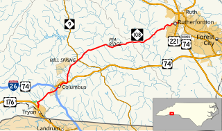
North Carolina Highway 108 is a 22-mile-long (35 km) two lane highway in North Carolina. It connects U.S. Route 176 in Tryon to Rutherfordton and passes through both Polk County and Rutherford County. It is a rural country road through eastern Polk County and western Rutherford County, and moderately developed from Tryon through Columbus and in Rutherfordton. It is also known as Lynn Road between Tryon and Columbus, Mills Street through Columbus, and Tryon Road in Rutherford County.

North Carolina Highway 120 (NC 120) is a primary state highway in the U.S. state of North Carolina. The highway connects the community of Cliffside and the town of Mooresboro.

North Carolina Highway 225 (NC 225) is a 10.7-mile (17.2 km) route running from U.S. Route 25 (US 25), near the South Carolina state line to Hendersonville. It crosses over US 25 once before ending. It runs through East Flat Rock and near Lake Summit.
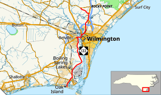
North Carolina Highway 133 (NC 133) is a primary state highway in the U.S. state of North Carolina. The road goes through historic downtown Wilmington and near Military Ocean Terminal Sunny Point.
Several special routes of U.S. Route 701 exist, from South Carolina to North Carolina. In order from south to north, separated by type, they are as follows.