
Oxfordshire is a county in South East England. The ceremonial county borders Warwickshire to the north-west, Northamptonshire to the north-east, Buckinghamshire to the east, Berkshire to the south, Wiltshire to the south-west and Gloucestershire to the west.

East Northamptonshire is a local government district in Northamptonshire, England. Its council is based in Thrapston and Rushden. Other towns include Oundle, Raunds, Irthlingborough and Higham Ferrers. The town of Rushden is the largest settlement in the district and the smallest settlement is the hamlet of Shotley. The population of the District Council at the 2011 Census was 86,765.
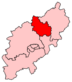
Kettering is a constituency in Northamptonshire represented in the House of Commons of the UK Parliament since 2005 by Philip Hollobone, a Conservative.

Bugbrooke St Michaels Football Club is an English football club based in Bugbrooke, Northamptonshire. They are members of the United Counties League Division One and play at Birds Close.
Pitsford Weather Centre, formerly Pitsford Hall weather station, is an climatological station maintained by Pitsford School in the village of Pitsford, Northamptonshire. The centre was established in 1998 and issues local forecasts for the county as well as maintaining a detailed and continuous weather record. The centre maintains the Met Office climate station for Morthampton, officially known as Pitsford, Northampton. The centre is a regular contributor to weather-related articles in the local press and has featured on local and national TV and radio. An analysis of each month's weather as well special articles are published in the centre's Monthly Weather report received by the British Library and available online and in hard copy to subscribers. The weather station was ran by Sixth Form students using traditional meteorological instruments from its inception in 1998 until 2016 when the site became fully automatic and renamed Pitsford Weather Centre. Weather information is now available via Twitter and Facebook as well as smartphone apps for iPhone and Android.
Lactodurum was a town in the Roman province of Britannia. Today it is known as Towcester, located in the English county of Northamptonshire.
Wootton Brook is a tributary of the River Nene which runs through Northamptonshire. The brook begins south of Great Houghton flowing south west through Preston Deanery and then east in the valley between Collingtree, Grange Park and East Hunsbury. It then flows south of West Hunsbury joining the River Nene at the west side of Northampton at Upton Mill. A number of small streams join the Brook along the way. In 1992 the stream overflowed into properties in parts of West Hunsbury.
The Wooldale Centre for Learning (WCL), is situated in Wootton, Northamptonshire. As well as being home to Caroline Chisholm School; a primary school and secondary school it also offers a very wide range of weekday evening and weekend activities. It used to be the home of the local library for Wootton and Wootton Fields area but in 2013, the library was moved to Wotton Community Centre.
The Town Ground in Peterborough, England, is a cricket ground which was used by Northamptonshire County Cricket Club in First-class matches for 60 years between 1906 and 1966. It is now used predominantly for Northamptonshire Premier League games, serving as the home ground of Orton Park CC.

Heart Four Counties is a local radio station owned and operated by Global Radio as part of the Heart network. It broadcasts to Bedfordshire, Buckinghamshire, Hertfordshire and Northamptonshire. The station launched on Friday 16 July 2010 as a result of a merger between Heart Milton Keynes, Heart Northants, Heart Dunstable and Heart Bedford.

The Church of All Saints is an Anglican Church and the parish church of Lamport, Northamptonshire. It is a Grade I listed building and stands on the north side of the High Street.

St Andrew’s Church is an Anglican church and the parish church of Old, Northamptonshire. It is a Grade I listed building and stands at Church Lane, on the south side of the village.
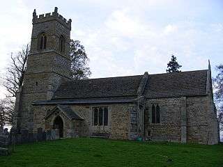
St Helen's Church is an Anglican Church and the parish church of Oxendon. It is a Grade II* listed building and stands on the west side of Harborough Road, to the north of the village of Great Oxendon.

St Catherine's Church is an Anglican Church and the parish church of Draughton. It is a Grade II* listed building and stands in the village of Draughton.

St Mary the Virgin's Church is an Anglican Church and the parish church of Maidwell, Northamptonshire. It is a Grade II* listed building and stands on the south side of Draughton Road.

Mill Crook is a 5.9 hectare biological Site of Special Scientific Interest east of Towcester in Northamptonshire. Mill Crook and Grafton Regis Meadow are a 7.9 hectare nature reserve managed by the Wildlife Trust for Bedfordshire, Cambridgeshire and Northamptonshire.
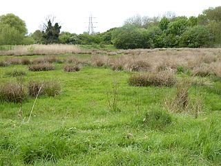
Abington Meadows is a 9.6 hectare nature reserve in Northampton. It is owned by Northamptonshire County Council and managed by the Wildlife Trust for Bedfordshire, Cambridgeshire and Northamptonshire.


