
Bates County is a county located in the west central part of the U.S. state of Missouri, two counties south of the Missouri River. As of the 2010 census, the population was 17,049. Its county seat is Butler. The county was organized in 1841 and named after Frederick Bates, the second Governor of Missouri.

Hendersonville is a city in Henderson County, North Carolina, United States. It is 22 miles (35 km) south of Asheville and is the county seat of Henderson County. Like the county, the city is named for 19th-century North Carolina Supreme Court Chief Justice Leonard Henderson.

Chelsea Market is a food hall, shopping mall, office building and television production facility located in the Chelsea neighborhood of the borough of Manhattan, in New York City. The Chelsea Market complex occupies an entire city block with a connecting bridge over Tenth Avenue to the adjacent 85 Tenth Avenue building. The High Line passes through the 10th Avenue side of the building.
The Country Club Historic District is located in Omaha, Nebraska from 50th to 56th Streets, from Corby to Seward Streets. With dozens of homes built between 1925 and 1949 in the late 19th and 20th Century Revival styles, the community was added to the National Register of Historic Places in 2004.

The Gold Coast Historic District is located in Midtown Omaha, Nebraska. Listed on the National Register of Historic Places in 1997, this historic district covers approximately a 30 block area roughly bounded by 36th, 40th, Jones, and Cuming Streets. The neighborhood housed many of Omaha's cultural and financial leaders between 1900 and 1920, taking over from Omaha's original Gold Coast in prominence.

The Omaha Rail and Commerce Historic District, roughly bounded by Jackson, 15th, and 8th Streets, as well as the Union Pacific main line, is located in downtown Omaha, Nebraska. Today this historic district includes several buildings listed individually on the National Register of Historic Places, including the Union Pacific Depot and the Burlington Station.

The Old Dauphin Way Historic District is a historic district in the city of Mobile, Alabama, United States. It was named for Dauphin Way, now known as Dauphin Street, which bisects the center of the district from east to west. The district is roughly bounded by Broad Street on the east, Springhill Avenue on the north, Government Street on the south, and Houston Avenue on the west. Covering 766 acres (3.10 km2) and containing 1466 contributing buildings, Old Dauphin Way is the largest historic district in Mobile.
The Lower Dauphin Street Historic District is a historic district in the city of Mobile, Alabama, United States. It was placed on the National Register of Historic Places on 9 February 1979. The district encompasses all of Dauphin Street from Water Street to Jefferson Street. It covers 551 acres (2.23 km2) and contains 736 contributing buildings. The boundaries were increased on 19 February 1982, 30 June 1995, and 14 August 1998. The buildings range in age from the 1820s to the 20th century and include the Federal, Greek Revival, Queen Anne, Italianate, and various other Victorian architectural styles.
The Leinkauf Historic District is a historic district in the city of Mobile, Alabama, United States. It was placed on the National Register of Historic Places on June 24, 1987. It is roughly bounded by Government, Eslava, Lamar, and Monterey Streets. The district covers 1,100 acres (4.5 km2) and contains 303 contributing buildings. The buildings range in age from the 1820s to early 20th century and cover a variety of 19th- and 20th-century architectural styles.
The Ashland Place Historic District is a historic district in the city of Mobile, Alabama, United States. The neighborhood gained its name from a Greek Revival antebellum house called Ashland that once stood on Lanier Avenue. Ashland was famous as the home of Augusta Evans Wilson. The house burned in 1926. The Ashland Place Historic District was placed on the National Register of Historic Places on June 23, 1987. It is roughly bounded by Spring Hill Avenue, Ryan Avenue, Old Shell Road, and Levert Avenue. The district covers 400 acres (1.6 km2) and contains 93 contributing buildings. The majority of the buildings date to the early 20th century and cover a variety of historical architectural styles ranging from late Victorian to the Craftsman styles.

The Campground Historic District, also known as The Campground is a historic district in the city of Mobile, Alabama, United States. Named for the Old Camp Ground, a military encampment that occupied the property during the American Civil War, this historically African-American neighborhood was placed on the National Register of Historic Places on July 7, 2005. It is roughly bounded by Martin Luther King Jr. Avenue, Rylands Street, St. Stephens Road, and Ann Street. The district covers 370 acres (1.5 km2) and contains 166 contributing buildings. The houses range from shotgun houses to bungalows and date from the late 19th century to the middle 20th century.

The Schenley Farms Historic District, also referred to as the Schenley Farms–Oakland Civic District, is a historic district listed on the National Register of Historic Places that is located in the Oakland section of Pittsburgh, Pennsylvania, United States.
This is a list of properties and districts in Manhattan from 14th to 59th Streets that are listed on the National Register of Historic Places.

This is a list of the National Register of Historic Places listings in Beaver County, Pennsylvania.

This is a list of the National Register of Historic Places listings in Caroline County, Virginia.

This is a list of the National Register of Historic Places listings in Wabasha County, Minnesota. It is intended to be a complete list of the properties and districts on the National Register of Historic Places in Wabasha County, Minnesota, United States. The locations of National Register properties and districts for which the latitude and longitude coordinates are included below, may be seen in an online map.
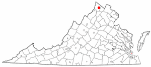
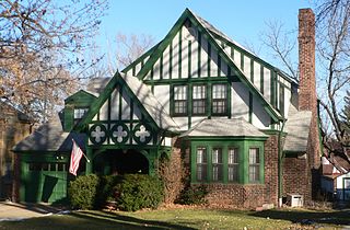
This is a list of the National Register of Historic Places listings in Winchester, Virginia.

There are 65 properties listed on the National Register of Historic Places in Albany, New York, United States. Six are additionally designated as National Historic Landmarks (NHLs), the most of any city in the state after New York City. Another 14 are historic districts, for which 20 of the listings are also contributing properties. Two properties, both buildings, that had been listed in the past but have since been demolished have been delisted; one building that is also no longer extant remains listed.

East Monument Historic District is a national historic district in Baltimore, Maryland, United States. It is a large residential area with a commercial area located along East Monument Street. It comprises approximately 88 whole and partial blocks. The residential area is composed primarily of row-houses that were developed, beginning in the 1870s, as housing for Baltimore's growing Bohemian (Czech) immigrant community. Most of the homes in the district were created after older homes were demolished in order to make room for expansions to the Johns Hopkins Hospital. During the late 19th and early 20th centuries the neighborhood was the heart of the Bohemian community in Baltimore. The Bohemian National Parish of the Roman Catholic Church, St. Wenceslaus, is located in the neighborhood.


