
Brighouse is a town within the metropolitan borough of Calderdale, in West Yorkshire, England. Historically within the West Riding of Yorkshire, it is situated on the River Calder, 4 miles (6.4 km) east of Halifax. It is served by Junction 25 of the M62 motorway and Brighouse railway station on the Caldervale Line and Huddersfield Line. In the town centre is a mooring basin on the Calder and Hebble Navigation. The United Kingdom Census 2001 gave the Brighouse / Rastrick subdivision of the West Yorkshire Urban Area a population of 32,360. The Brighouse ward of Calderdale Council gave a population of 11,195 at the 2011 Census. Brighouse has a HD6 postcode.

Rastrick is a village in the county of West Yorkshire, England, between Halifax, 5 miles (8 km) north-east and Huddersfield, 4 miles (7 km) south.

Calderdale is a metropolitan borough of West Yorkshire, England, which had a population of 211,439. It takes its name from the River Calder, and dale, a word for valley. The name Calderdale usually refers to the borough through which the upper river flows, while the actual landform is known as the Calder Valley. Several small valleys contain tributaries of the River Calder. The main towns of the borough are Brighouse, Elland, Halifax, Hebden Bridge, Sowerby Bridge and Todmorden.

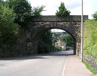
Clifton is a village on the eastern outskirts of Brighouse in the Calderdale district of West Yorkshire, England.
King Cross, originally the site of an ancient stone cross, is an ecclesiastical parish created in 1845 in the Metropolitan Borough of Calderdale, West Yorkshire, England. Part of the Diocese of Wakefield, it is located along the top of a ridge above the town of Halifax. The A58 road into Lancashire divides here, with one fork, the A646, branching off towards Burnley via Hebden Bridge and the other going to Littleborough via Sowerby Bridge. During the English Civil War, when Halifax was a Royalist stronghold, King Cross was a key outpost, with the Parliamentarians holding parts of the Calder Valley.
Bailiff Bridge is a village 1.5 miles (2.4 km) north from Brighouse, West Yorkshire, England, and is 5 miles (8.0 km) from Huddersfield and 7 miles (11 km) from Bradford. Bailiff Bridge falls within the Hipperholme and Lightcliffe Ward of Calderdale Council.
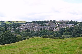
Lightcliffe is a village in the Calderdale district in West Yorkshire, England. Historically part of the West Riding of Yorkshire, it is situated approximately three miles east of Halifax and two miles north west of Brighouse. Lightcliffe was a separate parish in 1846 in the West Riding of Yorkshire.
Hipperholme is a village in West Yorkshire, England, located between the towns of Halifax and Brighouse in the Hipperholme and Lightcliffe ward of the Metropolitan Borough of Calderdale. The population of this ward at the 2011 Census was 11,308.

Halifax Choral Society (HCS) is a choir based in the town of Halifax in the English county of West Yorkshire. It is notable for being the oldest amateur choral society in Britain with an unbroken record of performance.

Hipperholme railway station served the village of Hipperholme in West Yorkshire, England.

Halifax is a town in the Metropolitan Borough of Calderdale, West Yorkshire, England. It is near the east Pennine foothills. In the 15th century, the town became an economic hub of the old West Riding of Yorkshire, primarily in woollen manufacture with the large Piece Hall square later built for trading wool in the town centre. The town was a thriving mill town during the Industrial Revolution with the Dean Clough Mill buildings a surviving landmark. In 2011, it had a population of 88,134. It is also the administrative centre of the wider Calderdale Metropolitan Borough.
Holywell Green is a village in the civil parish of Stainland and District, in the Calderdale, district, in the county of West Yorkshire, England. The village is situated approximately 1.4 miles (2 km) south-west of Elland, 3.3 miles (5 km) south of Halifax and 3.9 miles (6 km) north-west of Huddersfield. Holywell Green is part of the Greetland and Stainland Ward of Calderdale Council.

Lightcliffe railway station served the village of Lightcliffe in West Yorkshire, England. It was opened in August 1850 and was a victim of the Beeching cuts on 14 June 1965.

North Bridge, Halifax is a Victorian iron and stone bridge at Halifax, West Yorkshire, in northern England. It crosses the valley of the River Hebble, connecting the town to roads to Bradford and Leeds. Replacing an earlier six arch stone bridge, it was raised to allow the subsequent construction of the Halifax and Ovenden Joint Railway beneath it, including North Bridge railway station. Opened in 1871 amid chaotic crowd scenes it carried increasingly heavy traffic until it was by-passed by the Burdock Way in 1973. It remains in use for local traffic. On the south end of the structure was a theatre, adjoining the bridge, called the Grand Theatre.

The Municipal Borough of Brighouse was a local government district in the West Riding of Yorkshire from 1873 to 1974 around the town of Brighouse, covering Clifton, Hipperholme, Hove Edge, Lightcliffe, Rastrick and Southowram.

William Swinden Barber FRIBA, also W. S. Barber or W. Swinden Barber, was an English Gothic Revival and Arts and Crafts architect, specialising in modest but finely furnished Anglican churches, often with crenellated bell-towers. He was based in Brighouse and Halifax in the West Riding of Yorkshire. At least 15 surviving examples of his work are Grade II listed buildings, including his 1875 design for the Victoria Cross at Akroydon, Halifax. An 1864 portrait by David Wilkie Wynfield depicts him in Romantic garb, holding a flower. He served in the Artists Rifles regiment in the 1860s alongside Wynfield and other contemporary artists.

Royds Hall Manor is one of the surviving manor houses in the Yorkshire Region. It is a Grade II* listed building situated on an elevation over 700 feet above sea level in Bradford, West Yorkshire, England and was once the residence of the Lords of the Manor of North Bierley and Wibsey.

The 2016 Calderdale Metropolitan Borough Council election took place on 5 May 2016 to elect members of Calderdale Metropolitan Borough Council in England. This was on the same day as other local elections. One councillor was elected in each ward for a four-year term so the councillors elected in 2016 last stood for election in 2012. Each ward is represented by three councillors, the election of which is staggered, so only one third of the councillors was elected in this election. Before the election there was no overall control with a minority Labour administration. After the election there was still no overall control so the minority Labour administration continued.
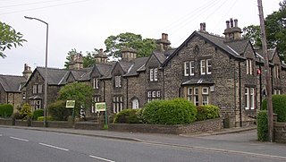
The ward of Hipperholme and Lightcliffe in the metropolitan borough of Calderdale, West Yorkshire, England, consists of the villages of Hipperholme and Lightcliffe together with the surrounding area. The ward contains 71 listed buildings that are recorded in the National Heritage List for England. Of these, three are at Grade II*, the middle of the three grades, and the others are at Grade II, the lowest grade. In addition to the villages of Hipperholme and Lightcliffe, the ward contains smaller settlements, including Bailiff Bridge, Coley, Hove Edge, and Norwood Green, and is otherwise rural. Most of the listed buildings are houses and associated structures, cottages, farmhouses and farm buildings. The other listed buildings include churches and an associated structures, a surviving tower from a former church, public houses, a school, a railway viaduct, a bridge, a milestone, a boundary stone and a war memorial.


