
Elmwood is a neighborhood in the South Side of Providence, Rhode Island. The triangular region is demarcated by Broad Street, Elmwood Avenue, and Interstate 95.

Saylesville is a village and historic district in Lincoln, Rhode Island.

The Smith Hill Historic District is a historic district located in northwestern Providence, Rhode Island, just west of the Rhode Island State House and Interstate 95. It includes 57-65 Brownell Street, 73-114 Holden Street, 23-80 Jewett Street, 189-240 Smith Street and 10-18 W. Park Street. This area is a densely built residential section, an isolated remnant of what was once a larger residential area. Most of the 41 properties are residential units built between 1870 and 1930, and are typically 2-1/2 or 3-1/2 stories in height. They are set on lot sizes ranging generally from 3000 to 5000 square feet, and are set close to the sidewalk. The only major non-residential buildings are St. Patrick's School at 244 Smith Street and "The Mohican" at 185-189 Smith Street; the latter is an Art Deco brick and concrete commercial block two stories in height.
The North End Historic District is a historic district in Woonsocket, Rhode Island encompassing an affluent residential area developed predominantly between about 1880 and 1930. It is bounded by Harris Avenue on the west, Winter Street on the north, Summer and Prospect Streets to the east, and Spring and Blackstone Streets to the south. It is separated from Woonsockets commercial and industrial heart by a neighborhood of densely populated worker housing. Most of the district's 224 major buildings are of relatively high quality and in good condition, and are reflective of the architectural styles that predominated in the late 19th and early 20th centuries: Queen Anne Victorian, Colonial Revival, and Tudor Revival forms and styles are the most common seen.

The Norwood Avenue Historic District is a residential historic district in Cranston and Providence, Rhode Island. It includes all of the properties along Norwood Avenue between Broad Street in Cranston and Green Boulevard in Providence. The street is lined with houses built for the most part between 1890 and 1930, which are stylistically Queen Anne and Colonial Revival in character.

The South Central Falls Historic District is a historic district in Central Falls, Rhode Island. It is a predominantly residential area, densely populated, which was developed most heavily in the late 19th century. It is bounded roughly by Broad Street to the east, the Pawtucket city line to the south, Dexter Street to the west, and Rand Street and Jenks Park to the north. It has 377 contributing buildings, most of which were built before 1920. The district was added to the National Register of Historic Places in 1991.
The Doyle Avenue Historic District is a predominantly residential historic district on the East Side of Providence, Rhode Island. It extends along Doyle Avenue from North Main Street in the west to Proctor Place. This area was developed residentially between 1860 and 1920, with an architecturally diverse collection of houses, generally set on small lots with only modest setback from the sidewalk. Land on the south side of Doyle Avenue was owned by the Dexter Commission, which managed a large tract of land bequested to the city by Ebenezer Dexter. This land was originally leased to developers. One of the first houses built in this area was the c. 1875 Thomas Collins House at 33 Doyle Avenue, a 2-1/2 story Italianate duplex.

The Freeman Plat Historic District is a residential historic district on the East Side of Providence, Rhode Island. The district is a well-preserved example of an early-20th-century planned residential area, encompassing some 50 acres (20 ha). It is roughly bounded by Sessions Street, Morris Avenue, Laurel Avenue, and Wayland Avenue, and consists of a network of generously-landscaped winding roads, laid out in consultation with the Olmsted Brothers design firm. The houses built are generally of high quality, many of them architect-designed, with architecturally diverse revival styles popular at the time. The area was developed between 1916 and 1929 by John Freeman, who owned a country estate in the area, and sought a way to develop the largely swampy tract.

The Parkis–Comstock Historic District is a residential historic district in the Elmwood neighborhood of Providence, Rhode Island. It includes all of the properties on Parkis Avenue and a number of properties on the western end of Comstock Street and Harvard Avenue, just across Broad Street from Parkis. The houses are set on relatively uniform large lots, generally set close to the street, and represent a fine collection of Late Victorian upper-class housing. Most of the houses were built between the 1860s and the 1910s. The first house to be built on Parkis Avenue was the c. 1869 Louis Comstock House at number 47; it has fine Second Empire styling, with corner quoining and a bracketed mansard roof.

The Pekin Street Historic District is a residential historic district bounded by Pekin and Candace Streets, Douglas and Chalkstone Avenues in Providence, Rhode Island. It is a well-preserved densely built neighborhood of working class housing, built almost entirely between 1870 and 1910. Most of the structures are either two or three-family units, with two-families predominating among the older buildings and triple-deckers among the later ones. The buildings are generally set on narrow lots with small yards. The district's main north-south roads are Pekin and Candace Streets, which are joined by a number of cross streets.

The Pine Street Historic District is a residential historic district on the south side of Providence, Rhode Island. It extends along Pine Street between Seekell and Myrtle Streets, and includes properties east of Pine and north of Pearl Street on Friendship, Prince, Maple, and Stewart Streets. The district represents an enclave of 19th-century residential housing in an area otherwise affected by urban renewal activities.
The Stimson Avenue Historic District is a residential historic district on the east side of Providence, Rhode Island. It includes all of Stimson Avenue and Diman Place, as well as adjacent properties on Angell Street on the south and Hope Street on the west, forming a relatively compact rectangular area. This area was developed roughly between 1880 and 1900, and features a collection of high-quality Queen Anne and Colonial Revival houses, with a few earlier Italianate houses at its edges. Among the finest is 19 Stimson Avenue, built in 1890 to a design by Stone, Carpenter & Willson; it is stylistically transitional between Queen Anne and Colonial Revival, featuring elaborate woodwork and a large number of exterior surface finishes, in a predominantly symmetrical Colonial Revival form. The only non-residential structure is the 1893 brick Central Congregational Church at 296 Angell Street.

The Summit Historic District is a residential historic district in northeastern Providence, Rhode Island. It is bounded on the east by Summit Avenue, the south by Rochambeau Avenue, the west by Camp Street, and the north by Memorial Road and Creston Way. It contains 155 houses, most of which were built between 1918 and 1938. The area was annexed by Providence in 1874 and platted out of farmland in 1916, and represents a typical suburban development of the period. Most of these houses are set on lots between 4,500 and 5,500 square feet in size, although there are some double lots. Single family homes predominate, with a number of two- and three-family houses present. Architecturally the houses are heterogeneous, with styles ranging from the late Queen Anne to the Colonial and Tudor Revivals. The only significant non-residential structure in the district is Temple Beth Shalom at 120 Rochambeau Avenue, which does not contribute to its significance.

The Wayland Historic District is a predominantly residential historic district on the east side of Providence, Rhode Island. It is a large area, covering about 122 acres (49 ha), bounded roughly on the north by Everett and Laurel Avenues, on the east by Blackstone Boulevard and Butler Avenue, on the west by Arlington Avenue, and on the south by Angell and South Angell Streets. This area, which was in the 19th century part of the Moses Brown farm, was platted for development in 1891, with most of the construction taking place in the early decades of the 20th century. Most of the residential properties in the district are single-family houses, typically built in revival styles popular at the time. They are set on similarly-sized lots with fairly uniform setbacks, and were typically built without garages. There are a number of two-family houses, and a small number of apartment buildings, most of which are found on the arterial roads of the area. There are several religious buildings, including several churches; the most architecturally distinctive religious building is the Jewish Temple Beth El, built 1951-54.

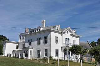
The Hope Village Historic District encompasses a historic mill village located in Scituate, Rhode Island. Located on a bend in the Pawtuxet River in southeastern Scituate, the area has seen industrial activity since the 18th century, and has surviving industrial and residential buildings from the early 19th century. The village is centered on the junction of Main Street and North Road, and radiates out from there, with numerous properties on smaller side streets. The present main mill building was built in 1844 by Brown & Ives, operators of numerous Rhode Island textile mills. Approximately 1/4 of the village's housing stock originated as mill worker housing built by the company.

Highland Heights–Stevens' Subdivision Historic District is a residential historic district located in Highland Park, Michigan along five east-west streets: Farrand Park, McLean Street, Colorado Street, Rhode Island Street, and Massachusetts Street, between Woodward Avenue on the west and Oakland Avenue on the east. The district was listed on the National Register of Historic Places in 1988.

The Greystone Historic District is a historic district encompassing the early 20th-century mill village of Greystone in North Providence, Rhode Island. The district most significant elements is the Greystone Mill, a complex of brick industrial buildings on the North Providence side of the Woonasquatucket River, as well as the dam spanning the river and a water tank in Johnston. The village, entirely in North Providence, was developed between 1904 and 1912 by Joseph Benn and Company, the mill proprietors, to provide housing for its workers. The main focus of the village is on junction of Greystone Road and Oakleigh Avenue. The company built a variety of housing types, including duplexes and tenements, which line some of the side streets. There are four houses, dating as far back as 1822, that predate the primary industrial activity here. The most prominent feature of the village is the Greystone (Primitive) Methodist Church on Oakleigh Avenue.

The Blackstone Boulevard–Cole Avenue–Grotto Avenue Historic District is a predominantly residential historic district roughly bounded by Blackstone Boulevard, Cole Avenue, Grotto Avenue, President and Rochambeau Avenues on the east side of Providence, Rhode Island. It encompasses one of the last areas of the city be developed residentially. Covering about 100 acres (40 ha), most of its building stock was built between about 1889 and the 1940s, with a notable building spurt taking place in the 1920s. The architecture in the area is heterogeneous, with Colonial and Georgian Revival styles predominating. The area was developed after the city built Blackstone Boulevard with the intention of developing the area into a streetcar suburb.

The Edgewood Historic District–Shaw Plat is a residential historic district in the Edgewood neighborhood of northeastern Cranston, Rhode Island. It is bounded by Broad Street on the west, Marion Avenue on the south, and Narragansett Bay on the east; it consists of the properties that line the parallel streets, Shaw and Marion Avenues, and the short section of Narragansett Boulevard that runs between Shaw and Marion Avenues. On the north it abuts the separately-listed Edgewood Historic District–Arnold Farm Plat. The area was platted out between 1867 and 1895, with construction of most of its housing taking place between 1867 and the start of World War II, with the most construction going on between 1895 and 1930. The district also includes the previously listed Edgewood Yacht Club. In 1853, the 25 acres of land that became the Shaw Plat was sold to Allen Shaw of Providence for $3,660.

The Rose Land Park Plat Historic District encompasses an early 20th-century neighborhood of East Providence, Rhode Island, most of which was built by a single development group. It is located on the west side of Willett Avenue, on Florence Street, Princeton and Dartmouth Avenues, and Roseland Court. The 7-acre (2.8 ha) district includes 38 residential buildings, and was mostly built between 1928 and 1939 as a streetcar suburb of Providence by Severin Carlson and Carl Johnson. The houses are mainly wood frame construction, and are stylistically English Revival, Colonial Revival, and traditional Cape Cod.


