
Mason County is a county located in the U.S. state of Washington. As of the 2020 census, the population was 65,726. The county seat and only incorporated city is Shelton. The county was formed out of Thurston County on March 13, 1854. Originally named Sawamish County, it took its present name in 1864 in honor of Charles H. Mason, the first Secretary of Washington Territory.

The Olympic Peninsula is a large arm of land in Western Washington that lies across Puget Sound from Seattle, and contains Olympic National Park. It is bounded on the west by the Pacific Ocean, the north by the Strait of Juan de Fuca, and the east by Hood Canal. Cape Alava, the westernmost point in the contiguous United States, and Cape Flattery, the northwesternmost point, are on the peninsula. Comprising about 3,600 square miles (9,300 km2), the Olympic Peninsula contained many of the last unexplored places in the contiguous United States. It remained largely unmapped until Arthur Dodwell and Theodore Rixon mapped most of its topography and timber resources between 1898 and 1900.
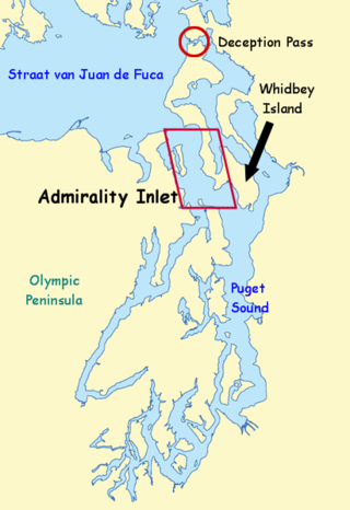
Admiralty Inlet is a strait in the U.S. state of Washington connecting the eastern end of the Strait of Juan de Fuca to Puget Sound. It lies between Whidbey Island and the northeastern part of the Olympic Peninsula.
The Kitsap Peninsula lies west of Seattle across Puget Sound, in Washington state in the Pacific Northwest. Hood Canal separates the peninsula from the Olympic Peninsula on its west side. The peninsula, a.k.a. "Kitsap", encompasses all of Kitsap County except Bainbridge and Blake Islands, as well as the northeastern part of Mason County and the northwestern part of Pierce County. The highest point on the Kitsap Peninsula is Gold Mountain. The U.S. Navy's Puget Sound Naval Shipyard, and Naval Base Kitsap are on the peninsula. Its main city is Bremerton.

Sinclair Inlet is a shallow embayment in the western part of Puget Sound in Kitsap County, Washington, USA. It has a maximum depth of 20 meters. It is the southwestern extension of Port Orchard, and it touches the shores of three of Kitsap County's four incorporated cities: Bremerton, Bainbridge Island, and Port Orchard. It is connected to Dyes Inlet by the Port Washington Narrows and to Puget Sound by Rich Passage. It was named by United States Navy explorer Charles Wilkes for George T. Sinclair, acting master of one of his ship's crews. The Puget Sound Naval Shipyard is located on the north shore of Sinclair Inlet.
Kamilche is an village in Mason County, Washington, United States. Primarily a farm area, Kamilche is also the home to the Squaxin Indian Tribe. It is at the crossroads of U.S. Route 101 and State Route 108. Kamilche sits at the edge of Little Skookum Inlet, a finger waterway off Puget Sound.
The Port Washington Narrows is a tidal strait located in Bremerton, Washington, United States. The northwest entrance is marked on the west side by Rocky Point, and the southeast entrance is located between Point Turner on the west side and Point Herron on the east side. The Narrows divides downtown Bremerton from the Manette Peninsula.

The Puget Sound Navigation Company (PSNC) was founded by Charles E. Peabody in 1898. Today the company operates an international passenger and vehicle ferry service between Port Angeles, Washington, United States and Victoria, British Columbia, Canada on the MV Coho, through its operating company, Black Ball Ferry Line.

Hammersley Inlet, in southwestern Puget Sound in the U.S. state of Washington, is an arm of water opening north of Arcadia and leading to the city of Shelton and Oakland Bay. Hammersley Inlet is also known as Big Skookum.
Carr Inlet, in southern Puget Sound in the U.S. state of Washington, is an arm of water between Key Peninsula and Gig Harbor Peninsula. Its southern end is connected to the southern basin of Puget Sound. Northward, it separates McNeil Island and Fox Island. The northern end of Carr Inlet is named Henderson Bay, which feeds into Burley Lagoon.
Case Inlet, in southern Puget Sound in the U.S. state of Washington, is an arm of water between Key Peninsula to the east and Harstine Island to the west. Its northern end, called North Bay, reaches nearly to Hood Canal, creating the defining isthmus of Kitsap Peninsula. Case Inlet is the boundary between Pierce County and Mason County. The southern end of Case Inlet connects to Nisqually Reach, part of the southern basin of Puget Sound. Herron Island lies in Case Inlet.

The Seattle-Tacoma Shipbuilding Corporation was an American corporation which built escort carriers, destroyers, cargo ships and auxiliaries for the United States Navy and merchant marine during World War II in two yards in Puget Sound, Washington. It was the largest producer of destroyers (45) on the West Coast and the largest producer of escort carriers of various classes (56) of any United States yard active during World War II.
Eld Inlet is an inlet located at the southern end of Puget Sound in Thurston County, Washington. It is the second southernmost arm of Puget Sound after neighboring Budd Inlet.
Bayshore was a small community located on Oakland Bay in southern Puget Sound, not far away from the present city of Shelton, Washington.
Agate is a small community in the state of Washington, United States. It is located on southern Puget Sound on the north side of the entrance to Hammersley Inlet.
Oyster Bay is an inlet in southern Puget Sound which branches off from Totten Inlet. The bay spans Mason and Thurston counties, in the U.S. state of Washington. Kennedy Creek empties into the bay at the U.S. Highway 101 overpass.
Little Skookum Inlet is a branch of southern Puget Sound which extends westward from Totten Inlet. The community of Kamilche, Washington is on Little Skookum Inlet. It is also the estuary and headwaters for the Little Skookum, Elson, Lynch and Mable Taylor Creeks. The Little Skookum and Totten Inlets flow southwest and form the Kamilche Peninsula, a headland jetting out from Kamilche, Washington.
Mud Bay is the southernmost reach of Puget Sound, at Eld Inlet just outside the city limits of Olympia, Washington. The name Eld Inlet was officially bestowed after a member of the U.S. Navy's Wilkes Expedition, but "Mud Bay" is a local, informal adoption.

South Puget Sound is the southern reaches of Puget Sound in Southwest Washington, in the United States' Pacific Northwest. It is one of five major basins encompassing the entire Sound, and the shallowest basin, with a mean depth of 37 meters (121 ft). Exact definitions of the region vary: the state's Department of Fish and Wildlife counts all of Puget Sound south of the Tacoma Narrows for fishing regulatory purposes. The same agency counts Mason, Jefferson, Kitsap, Pierce and Thurston Counties for wildlife management. The state's Department of Ecology defines a similar area south of Colvos Passage.

Taylor Shellfish Company is an American seafood company based in Shelton, Washington. It is the country's largest producer of aquaculture (farmed) shellfish and has locations across Western Washington. The Taylor family started raising Olympia oysters in the 1920s. In the current form, the company, privately held, was started in 1969 as Taylor United by brothers Edwin and Justin Taylor, grandsons of James Y. Waldrip, an early Washingtonian who came to Seattle to work rebuilding after the Great Seattle Fire of 1889 before moving south and founding the Olympia Oyster Company in the 1890s. Waldrip's company farmed the Olympia oyster found only in South Puget Sound. Justin Taylor, born 1921, the oldest oyster farmer on Puget Sound in the early 2000s, died in 2011.
