
West Warwick is a town in Kent County, Rhode Island, United States. The population was 31,012 at the 2020 census.

Riverside is a neighborhood in the city of East Providence in the U.S. state of Rhode Island. Despite not being an incorporated city, Riverside has its own zip code, 02915, and is an acceptable mailing address according to the United States Postal Service. Riverside has a population of approximately 20,000 people.
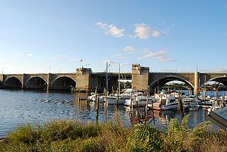
The Washington Bridge is a series of three bridges carrying Interstate 195, US Route 6, US Route 44, and U.S. Route 1A over the Seekonk River connecting India Point in Providence to Watchemoket Square in East Providence, Rhode Island. The historic portion of the bridge dating to 1930 serves as the pedestrian crossing, and bike link to the East Bay Bike Path. The pedestrian span is also a part of the Washington-Rochambeau National Historic Trail. As of December 11, 2023, the westbound bridge is closed to all but emergency vehicles due to critical safety issues.

The Westminster Arcade is a historic shopping center at 130 Westminster Street and 65 Weybosset Street in downtown Providence, Rhode Island built in 1828. It is notable as the first enclosed shopping mall in the United States and has been lauded as a fine example of commercial Greek Revival architecture. It served as a shopping center for many years before falling into decline in the late 20th century. It has since been closed for renovation and rehabilitation several times, and most recently reopened its doors in October 2013 as a residential and commercial mixed-use building. It was declared a National Historic Landmark in 1976.
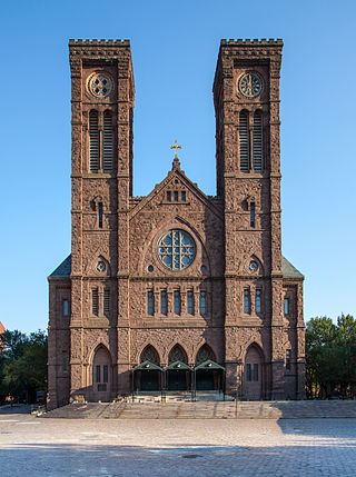
The Cathedral of Saints Peter and Paul is a Roman Catholic cathedral in the Cathedral Square neighborhood of Providence, Rhode Island, United States. It is the mother church of the Diocese of Providence. The Neo-Romanesque church was designed in 1873 by Patrick Keely and added to the National Register of Historic Places in 1975.

College Hill is a historic neighborhood of Providence, Rhode Island, and one of six neighborhoods comprising the city's East Side. It is roughly bounded by South and North Main Street to the west, Power Street to the south, Governor Street and Arlington Avenue to the east and Olney Street to the north. The neighborhood's primary commercial area extends along Thayer Street, a strip frequented by students in the Providence area.
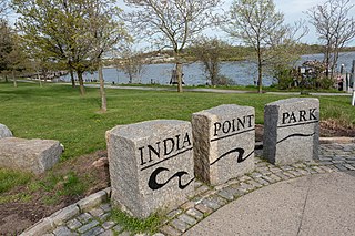
India Point Park is a park in the Fox Point neighborhood of Providence, Rhode Island at the confluence of the Seekonk River and Providence River. The park takes its name from the maritime activity connecting Providence with the East and West Indies. The East Bay Bike Path begins at the eastern end of the park, and crosses over the Washington Bridge before heading to Watchemoket Square in East Providence and continuing on to the Bristol waterfront north of the Mount Hope Bridge. The park is also a part of the Washington–Rochambeau Revolutionary Route.
Elmwood is a neighborhood in the South Side of Providence, Rhode Island. The triangular region is demarcated by Broad Street, Elmwood Avenue, and Interstate 95.

Downtown is the central economic, political, and cultural district of the city of Providence, Rhode Island, United States. It is bounded on the east by Canal Street and the Providence River, to the north by Smith Street, to the west by Interstate 95, and to the south by Henderson Street. The highway serves as a physical barrier between the city's commercial core and neighborhoods of Federal Hill, West End, and Upper South Providence. Most of the downtown is listed on the National Register of Historic Places as the Downtown Providence Historic District.

The Fleur-de-Lys Studios, also known as Fleur-de-Lis Studios or Sydney Burleigh Studio, is a historic art studio, and an important structure in the development of the Arts and Crafts Movement in the United States. It is located at 7 Thomas Street in the College Hill neighborhood of Providence, Rhode Island. It was designed by Sydney Burleigh and Edmund R. Willson, and built in 1885. It was added to the National Register of Historic Places and designated a National Historic Landmark in 1992. In addition, it is part of the College Hill Historic District.
The Newport Historic District is a historic district that covers 250 acres in the center of Newport in the U.S. state of Rhode Island. It was designated a National Historic Landmark (NHL) in 1968 due to its extensive and well-preserved assortment of intact colonial buildings dating from the early and mid-18th century. Six of those buildings are themselves NHLs in their own right, including the city's oldest house and the former meeting place of the colonial and state legislatures. Newer and modern buildings coexist with the historic structures.

The College Hill Historic District is located in the College Hill neighborhood of Providence, Rhode Island. It was designated a National Historic Landmark District on December 30, 1970. The College Hill local historic district, established in 1960, partially overlaps the national landmark district. Properties within the local historic district are regulated by the city's historic district zoning ordinance, and cannot be altered without approval from the Providence Historic District Commission.
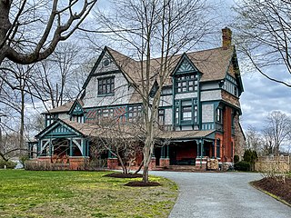
Charles H. Baldwin House is a historic house on Bellevue Avenue in Newport, Rhode Island, United States, that is part of the Bellevue Avenue Historic District, but is individually listed on the National Register of Historic Places (NRHP).

See also Daggett House, Slater Park, Pawtucket RI, built about the same time, by Nathaniel's father John.
The Blackstone Boulevard Realty Plat Historic District is a historic district roughly bounded by Blackstone Blvd., Rochambeau Ave., Holly St. and Elmgrove Ave. in Providence, Rhode Island.

The Brick Schoolhouse is a historic colonial school building at 24 Meeting Street in the College Hill neighborhood of Providence, Rhode Island. The structure is noted as the home of one of the first free schools in the United States and the first brick schoolhouse in the city of Providence. In 1828, the schoolhouse became the first public school to be open to African American children. Since the 1960s, the Providence Preservation Society has leased the structure from the city for use as a meeting hall.

Grace Church is an historic Episcopal church at 300 Westminster Street at Mathewson Street in downtown Providence, Rhode Island. It was built in 1845-46 and was designed by Richard Upjohn in the Gothic Revival style.

The Market House is a historic three-story brick market house in Market Square, in the College Hill, a neighborhood of Providence, Rhode Island, USA. The building was constructed between 1773 and 1775 and designed by prominent local architects, Joseph Brown and Declaration of Independence signer Stephen Hopkins. The bottom floor of the house was used as a market, and the upper level was used for holding meetings. Similar buildings existed in other American cities, such as Faneuil Hall in Boston and the Old Brick Market in Newport. The building housed the Providence City Council in the decades before the completion of City Hall.

The Kent County Courthouse, now the East Greenwich Town Hall, is a historic court building at 127 Main Street in East Greenwich, Rhode Island.
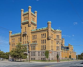
The Cranston Street Armory is an historic building in the Broadway–Armory Historic District of Providence, Rhode Island. It was built in 1907 at a cost of $650,000.00. The building was occupied by the Rhode Island National Guard from its opening until 1996. Since then, parts of the building have been used as film studios, and some of its offices occupied by the Rhode Island State Fire Marshal. The National Trust for Historic Preservation listed the Armory as one of "America's 11 Most Endangered Historic Places" in its annual list for 1997. Its distinctive yellow bricks, crenellated turrets, and decorative stonework mark it as a historically significant building and neighborhood icon.


