Related Research Articles

Lillooet, formerly Cayoosh Flat, is a community on the Fraser River in British Columbia, Canada, about 240 kilometres (150 mi) up the British Columbia Railway line from Vancouver. Situated at an intersection of deep gorges in the lee of the Coast Mountains, it has a dry climate with an average of 329.5 millimetres (13 in) of precipitation being recorded annually. Lillooet has a long growing season, and once had prolific market gardens and orchard produce. It often vies with Lytton and Osoyoos for the title of "Canada's Hot Spot" on a daily basis in summer.

Auraria is a ghost town in Lumpkin County, Georgia, United States, southwest of Dahlonega. Its name derives from aurum, the Latin word for gold. In its early days, it was also known variously as Dean, Deans, Nuckollsville, and Scuffle Town.

Ojuela was a small mining settlement located northwest of the nearest town Mapimí, 5 kilometres (3.1 mi) northwest. The settlement is now well known as a ghost town as a result of the ore being exhausted.

The Bridge River is an approximately 120 kilometres (75 mi) long river in southern British Columbia. It flows south-east from the Coast Mountains. Until 1961, it was a major tributary of the Fraser River, entering that stream about six miles upstream from the town of Lillooet; its flow, however, was near-completely diverted into Seton Lake with the completion of the Bridge River Power Project, with the water now entering the Fraser just south of Lillooet as a result.
The Hurley River is a major tributary of the Bridge River of west-central British Columbia that was earlier known as the South Fork of that larger river. It was for a while known as "Hamilton's River" after Danny Hamilton, an American who was among the first to settle in the goldfields region of the upper Bridge River. By the 1920s that name was changed to the Hurley River, commemorating one of the main pioneers of the Lillooet Country, Dan Hurley.

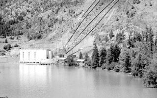
Minto City, often called just Minto, sometimes Minto Mines or Minto Mine, was a gold mining town in the Bridge River Valley of British Columbia from 1930 to 1936, located at the confluence of that river with Gun Creek, one of its larger tributaries. It was first called the Alpha group of claims in the 1920s, when underground miners were exploring the seams of Cadwallader Creek and the origins of the placer deposits downstream in the Bridge River. The mine prospect was never much successful although a model townsite was built by promoter "Big Bill" Davidson, who imported soil to build a specially-built rodeo ground and baseball diamond on the rocky site. The larger mine of Bralorne was nearby. The mine shut down in 1936 due to productivity issues, but restarted in 1940. The valley has since been significantly altered when most of the vestiges of the town were inundated by the waters of the Carpenter Lake reservoir following completion of the Bridge River Power Project. The town sat on the western end of the lake near the present Carpenter Lake Road, part of the road drove through a wooden Tudor arch built into the rock mill.
Gold Bridge is an unincorporated community in the Bridge River Country of British Columbia, Canada. Although numbering only around 40 inhabitants, Gold Bridge is the service and supply centre for the upper basin of the Bridge River Valley, which includes recreation-residential areas at the Gun Lakes, Tyaughton Lake, Marshall Creek, and Bralorne; and the nearby ghost towns of Brexton and Pioneer Mine.
The Bridge River Power Project is a hydroelectric power development in the Canadian province of British Columbia, located in the Lillooet Country between Whistler and Lillooet. It harnesses the power of the Bridge River, a tributary of the Fraser, by diverting it through a mountainside to the separate drainage basin of Seton Lake, utilizing a system of three dams, four powerhouses and a canal.
Coalmont is a tiny mining town, 11 miles (18 km) northwest of Princeton, British Columbia, Canada, on the north bank of the Tulameen River. The population of Coalmont is roughly 100 full-time residents. It is near the community of Tulameen and Otter Lake and the Coldwater Junction of the Coquihalla Highway. The town was established in 1912 to serve as a supply point to the neighbouring coal mine at Blakeburn.
The Similkameen Gold Rush, also known as the Blackfoot Gold Rush, was a minor gold rush in the Similkameen Country of the Southern Interior of British Columbia, Canada, in 1860. The Similkameen Rush was one of a flurry of small rushes peripheral to the Fraser Canyon Gold Rush, which had drawn tens of thousands of prospectors to the new colony in 1858-1859, among the others being Rock Creek Gold Rush and Big Bend.
Bridge River was used to describe three separate towns or localities in the Lillooet Country of the Interior of British Columbia connected with the river and valley of the same name.
Cadwallader Creek is an important tributary of the Hurley River in the Bridge River Country of the British Columbia Interior, Canada, most notable for its role as the home of the Bralorne and Pioneer Mines and associated gold claims and workings. Less than twenty miles in length, the creek is joined by Noel Creek within the area of the town of Bralorne, and just below Bralorne joins the Hurley River just above Hurley Falls and that river's ten-mile canyon prior to its own confluence with the Bridge River near the town Gold Bridge. Standard Creek, a short tributary of Cadwallader Creek near its upper end, connects via McGillvray Pass to the creek of the same name and, on Anderson Lake far below, the resort townlet of McGillivray Falls. One-time plans to build a cog railway to the mines from the Pacific Great Eastern at McGillivary Falls were never fulfilled.

Bralorne is a historic Canadian gold mining community in the Bridge River District, some eighty dirt road miles west of the town of Lillooet.

Gun Lake, often spelled Gunn Lake and also known as Big Gun Lake, is a lake and unincorporated community in the Bridge River Country of the West-Central Interior of British Columbia, Canada, located 5 miles northwest of the community of Gold Bridge. It is approximately 10 km in length and is roughly pistol-shaped when seen from above, and drains via a short connecting creek to Gun Creek, which is an important tributary of the Bridge River, joining it via Carpenter Lake. Lajoie Lake, which is just southwest, is also known as Little Gun Lake and is also a small community. The two together are generally referred to as the Gun Lakes.
The Cadwallader Range, originally named the Cadwallader Mountains, is a sub-range of the Pacific Ranges of the Coast Mountains in the Bridge River-Lillooet Country of the South-Central Interior of British Columbia, Canada, located between the south end of Anderson Lake (E) and the Hurley River. According to the provincial basemap, the precise alpine boundaries of the range are McGilliray Pass, at its eastern extremity and beyond which is the Bendor Range, and the pass between Noel and Sockeye Creeks on its west, which is immediately north of the lower end of Birkenhead Lake. The officially unnamed range west of that has been called the Noel Range, after its main peak Mount Noel. At the foot of the range along its northeast flank is Cadwallader Creek, scene of the historic and once-rich Bralorne and Pioneer Mines and the ghost town of Bralorne.
Camborne is a locality and former galena-mining town on the east side of the Incomappleux River, northeast of the head of Beaton Arm of Upper Arrow Lake, in the West Kootenay region of southern British Columbia.
Brexton, formerly known as Fish Lake, is a ghost town located in the Bridge River Country region of British Columbia. Although the provincial Gazetteer still lists the "settlement" of Brexton, which was situated between the southeast end of Gun Lake and Gold Bridge, and three and a half miles north of Bralorne, this once busy town has mostly vanished though a few buildings remain. The old town site now sits mainly on private property.
Haylmore is a location in the Bridge River Country of the southwestern Interior of British Columbia, Canada, located near the town of Gold Bridge just below the confluence of the Bridge River and its south fork, the Hurley River.
References
- Bridge River Gold, Emma de Hullu, Irene Cunningham and others, self-publ.
- The Great Years: Mining in the Bridge River Valley, Lewis Green, Tricouni (Vancouver), 2001
Coordinates: 50°47′20″N122°49′34″W / 50.789°N 122.826°W
| This article about a location in the Cariboo Regional District, Canada is a stub. You can help Wikipedia by expanding it. |
| This Canadian ghost town-related article is a stub. You can help Wikipedia by expanding it. |