
Bath and North East Somerset is the district of the unitary authority of Bath and North East Somerset Council that was created on 1 April 1996 following the abolition of the county of Avon. It is part of the ceremonial county of Somerset.

Castle Cary is a small market town and civil parish in south Somerset, England, 5 miles (8 km) north west of Wincanton and 8 miles (12.9 km) south of Shepton Mallet, at the foot of Lodge Hill and on the River Cary, a tributary of the Parrett.
Chew Stoke is a small village and civil parish in the Chew Valley, in Somerset, England, about 8 miles (13 km) south of Bristol. It is at the northern edge of the Mendip Hills, a region designated by the United Kingdom as an Area of Outstanding Natural Beauty, and is within the Bristol/Bath green belt. The parish includes the hamlet of Breach Hill, which is approximately 2 miles (3.2 km) southwest of Chew Stoke itself.

Pensford is the largest village in the civil parish of Publow in Somerset, England. It lies in the Chew Valley, approximately 7 miles (11 km) south of Bristol and 8 miles (13 km) west of Bath. It is on the A37 road from Bristol to Shepton Mallet.

Keinton Mandeville is a village and civil parish in Somerset, England, situated on top of Combe Hill, 6 miles (9.7 km) west of Castle Cary in the South Somerset district. The village has a population of 1,068. It is next to Barton St David.
Queen Camel is a village and civil parish, on the River Cam and the A359 road, in the South Somerset district of Somerset, England. It is about 7 miles (11.3 km) north of Yeovil. According to the 2011 census it had a population of 908. The parish includes the hamlet of Wales. Nearby places are West Camel, Sparkford and Marston Magna.

Bishop Sutton is a small village within the Chew Valley in Somerset. It lies south of Chew Valley Lake and north of the Mendip Hills, approximately ten miles south of Bristol on the A368, Weston-super-Mare to Bath road. Bishop Sutton and the neighbouring village of Stowey form the civil parish of Stowey Sutton.

East Harptree is a village and civil parish in Somerset, England. It is situated 5 miles (8.0 km) north of Wells and 15 miles (24.1 km) south of Bristol, on the northern slope of the Mendip Hills overlooking the Chew Valley. The parish has a population of 644. The parish includes the hamlet of Coley.
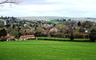
The Chew Valley is an area in North Somerset, England, named after the River Chew, which rises at Chewton Mendip, and joins the River Avon at Keynsham. Technically, the area of the valley is bounded by the water catchment area of the Chew and its tributaries; however, the name Chew Valley is often used less formally to cover other nearby areas, for example, Blagdon Lake and its environs, which by a stricter definition are part of the Yeo Valley. The valley is an area of rich arable and dairy farmland, interspersed with a number of villages.

Chelwood is a small village and civil parish within the Chew Valley in North Somerset about 8 miles (13 km) from Bristol and Bath. The parish has a population of 148.

Ubley is a small village and civil parish within the Chew Valley in Bath and North East Somerset about 8 miles (12.9 km) south of Bristol and 10 miles (16.1 km) from Bath. It is just south-east of Blagdon Lake on the A368 between Compton Martin and Blagdon.

Norton Malreward is a small Somerset village and civil parish 4 miles (6.4 km) south of Bristol, England at the northern edge of the Chew Valley. In 1895 Norton Malreward was combined with the neighbouring hamlet of Norton Hawkfield into a single parish, which has a population of 246.
Compton Dando is a small village and civil parish on the River Chew in the Chew Valley in England. It is in the District of Bath and North East Somerset and ceremonial county of Somerset, and lies 7 miles (11.3 km) from Bristol, 8 miles (12.9 km) from Bath, and 3 miles (4.8 km) from Keynsham.

Stowey is a small village within the Chew Valley in Somerset, England. It lies south of Chew Valley Lake and north of the Mendip Hills, approximately 10 miles (16 km) south of Bristol on the A368 road Weston-super-Mare to Bath. Stowey and its neighbouring and larger village, Bishop Sutton, form the civil parish of Stowey Sutton.
Hinton Blewett is a village and civil parish in Somerset, England, 5 miles (8.0 km) north of Wells and 15 miles (24.1 km) south of Bristol on the northern slope of the Mendip Hills, within the designated Area of Outstanding Natural Beauty (AONB) and in the Chew Valley near the source of the River Chew. The parish has a population of 308.

Stanton Drew is a small village and civil parish within the Chew Valley in Somerset, England, situated north of the Mendip Hills, 8 miles (12.9 km) south of Bristol in the Bath and North East Somerset Unitary Authority.

Chilton Polden is a rural village and civil parish, situated close to Edington on the Somerset Levels to the north of the Polden Hills in the Sedgemoor district of Somerset, England.

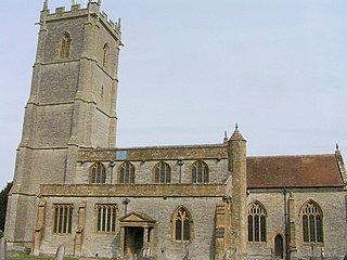
The Church of St Margaret in Hinton Blewett, Somerset, England probably dates from the 13th century although parts are as late as the 16th or 17th century. It has been designated as a Grade I listed building.

Chew Court is a Grade II* listed building next to St Andrew's church in Chew Magna, Somerset, England.


