Oldshoremore

Last updated

Oldshoremore
Sutherland UK location map.svg
Red pog.svg
Oldshoremore
Location within the Sutherland area
OS grid reference NC211583
Civil parish
  • Eddrachillis
Council area
Lieutenancy area
Country Scotland
Sovereign state United Kingdom
Postcode district IV27 4
Police Scotland
Fire Scottish
Ambulance Scottish
List of places
UK
Scotland
58°28′34″N5°04′08″W / 58.47615°N 5.06882°W / 58.47615; -5.06882

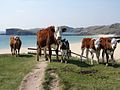
Oldshoremore is a scattered crofting hamlet in the Eddrachillis parish of Sutherland, Scotland. It incorporates around twenty houses, though several of these are holiday homes.

View of Oldshoremore from the slopes of Eilean na h-Aiteig Rocky coastline beyond Oldshoremore Beach - geograph.org.uk - 443294.jpg
View of Oldshoremore from the slopes of Eilean na h-Aiteig

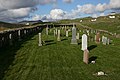
Once owned by the Duke of Sutherland, Oldshoremore and the surrounding area are now part of the Sandwood Estate, a nature reserve owned by the John Muir Trust. Directly west lies Oldshoremore Bay, a sandy beach with a large headland at its northern end known as Eilean na h-Aiteig. The hamlet also contains a car park, toilet facilities, a post box, and a cemetery. A small loch known as Loch Àisir lies to the east.

The nearest sizeable settlement is Kinlochbervie, which lies approximately one mile (1.5 kilometres) southeast. The hamlet of Oldshore Beg lies to the northwest.

Related Research Articles

<span class="mw-page-title-main">Sutherland</span> Historic county in Scotland

Sutherland is a historic county, registration county and lieutenancy area in the Highlands of Scotland. Its county town is Dornoch. Sutherland borders Caithness and Moray Firth to the east, Ross-shire and Cromartyshire to the south and the Atlantic to the north and west. Like its southern neighbour Ross-shire, Sutherland has some of the most dramatic scenery in Europe, especially on its western fringe where the mountains meet the sea. These include high sea cliffs and very old mountains composed of Precambrian and Cambrian rocks.

<span class="mw-page-title-main">Durness</span> Human settlement in Scotland

Durness is a village and civil parish in the north-west Highlands of Scotland. It lies on the north coast of the country in the traditional county of Sutherland, around 120 miles north of Inverness. The area is remote, and the parish is huge and sparsely populated, covering an area from east of Loch Eriboll to Cape Wrath, the most north-westerly point of the Scottish mainland.

<span class="mw-page-title-main">Kinlochbervie</span> Human settlement in Scotland

Kinlochbervie is a scattered harbour village in the north west of Sutherland, in the Highland region of Scotland. It is the most northerly port on the west coast of Scotland.

<span class="mw-page-title-main">Kinlochbervie High School</span> School in Kinlochbervie, Sutherland, Scotland

Kinlochbervie High School is a secondary school in Kinlochbervie, in the county of Sutherland in the northwest of Scotland.

<span class="mw-page-title-main">Am Buachaille</span> Sea stack in Highland, Scotland

Am Buachaille is a sea stack, or vertical rock formation composed of Torridonian Sandstone, 1 mile southwest of Sandwood Bay in the Scottish county of Sutherland. It lies at the tip of the Rubh' a Bhuachaille headland around 5 miles north of Kinlochbervie.

<span class="mw-page-title-main">Achriesgill</span> Human settlement in Scotland

Achriesgill is a village that lies on the eastern bank of Loch Inchard in Lairg, Sutherland, in the Scottish council area of Highland. The village is on the road to Kinlochbervie.

<span class="mw-page-title-main">Sandwood Bay</span>

Sandwood Bay is a natural bay in Sutherland, on the far north-west coast of mainland Scotland. It is best known for its remote 1-mile-long (1.6 km) beach and Am Buachaille, a sea stack, and lies about 5 miles south of Cape Wrath. Behind the bay's large dunes, stretches the freshwater Sandwood Loch.

<span class="mw-page-title-main">Loch Veyatie</span> Freshwater loch

Loch Veyatie is a large freshwater loch in north-west Scotland. It stretches for 6 km north-westwards from the settlement of Elphin, and lies between Suilven and Cùl Mòr. The loch is located in an area known as the Assynt-Coigach National Scenic Area, one of 40 such areas in Scotland.

<span class="mw-page-title-main">Kylesku</span> Human settlement in Scotland

Kylesku is a small, remote fishing hamlet in Sutherland in the Scottish Highlands. Until 1984, it was the site of a free ferry. The name is possibly a combination of "Kyle" - Scots Gaelic for strait or channel - and Old Norse "Sku" - view or sight.

Balchrick is a township on the north east shore of Lairg in Sutherland, Scottish Highlands and is in the Scottish council area of Highland.

Blairmore is a small remote crofting hamlet, on the north west coast of Lairg in Sutherland, Scottish Highlands and is in the Scottish council area of Highland.

<span class="mw-page-title-main">Droman, Sutherland</span> Human settlement in Scotland

Droman is a small remote crofting township on the north west coast of Lairg in Sutherland, Scottish Highlands and is in the Scottish council area of Highland.

Rhiconich is a remote hamlet, located at the head of Loch Inchard, in Sutherland, Scottish Highlands in the Scottish council area of Highland. Rhiconich is situated 3 miles (4.8 km) north-east of Laxford Bridge and 11 miles (18 km) south-west of Durness on the A838 road. The B801 at Richonich links the village of Kinlochbervie and associated crofting townships such as Oldshoremore to the A838.

Badcall comprises two remote hamlets, called Lower Badcall and Upper Badcall. Upper Badcall, a crofting township, is the larger of the two and is situated on the western shore of Badcall Bay. Lower Badcall is located less than 1 mile to the east on the eastern shore of Badcall Bay. Badcall is on the west coast of Sutherland, Scottish Highlands and is in the Scottish council area of Highland.

Badcall is the name of several small settlements in Sutherland in northwest Scotland:

Badcall is a remote crofting township, located on the northern shore of the sea loch, Loch Inchard, in Sutherland, Scottish Highlands and is in the Scottish council area of Highland.

<span class="mw-page-title-main">Kyle of Durness</span> Bay in Highland, Scotland, UK

Kyle of Durness is a coastal inlet on the north coast of Scotland in the county of Sutherland. It extends 5+12 miles inland from Balnakeil and divides the Cape Wrath peninsula from the mainland. The nearest village is Durness.

<span class="mw-page-title-main">Loch Kirkaig</span>

Loch Kirkaig is a small tidal sea loch, located in the region and parish of Assynt in south-west of Sutherland, in the west coast of Scotland and in the Scottish Highlands. Loch Kirkaig is 1.25 miles south of Loch Inver. The scattered crofting township of Inverkirkaig is located at the headland of the bay, next to the pebbly beach, on the round bay, which has no known name. The name Kirgaig comes from old Norse, Kirkju-vik meaning church bay, perhaps suggesting that in Viking times, there was a church, with a village located in the bay.

Eddrachillis is a civil parish in north-west Sutherland, Scotland. In Gaelic it means: between two firths. For local government, it forms part of the Highland Unitary Authority.

References