Oxfordshire is a county in South East England. The ceremonial county borders Warwickshire to the north-west, Northamptonshire to the north-east, Buckinghamshire to the east, Berkshire to the south, Wiltshire to the south-west and Gloucestershire to the west.

A factory,manufacturing plant or a production plant is an industrial site, usually consisting of buildings and machinery, or more commonly a complex having several buildings, where workers manufacture goods or operate machines processing one product into another.

New Hartford is a town in Oneida County, New York, United States. As of the 2010 census, the town population was 22,166. The name of New Hartford was provided by a settler family from Hartford, Connecticut.
A percentile is a measure used in statistics indicating the value below which a given percentage of observations in a group of observations falls. For example, the 20th percentile is the value below which 20% of the observations may be found.
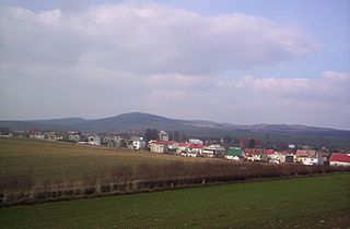
Piława Górna is a town in Dzierżoniów County, Lower Silesian Voivodeship, in south-western Poland, in the western part of the Wzgórza Strzelińskie hills. Prior to 1945 it was in Germany. It lies approximately 15 kilometres (9 mi) east of Dzierżoniów, and 54 kilometres (34 mi) south of the regional capital Wrocław.

The Elder Futhark, Elder Fuþark, Older Futhark, Old Futhark or Germanic Futhark is the oldest form of the runic alphabets. It was a writing system used by Germanic tribes for Northwest Germanic dialects in the Migration Period, the dates of which are debated among scholars. Runic inscriptions are found on artifacts, including jewelry, amulets, tools, weapons, and, famously, runestones, from the 2nd to the 8th centuries.

A tower mill is a type of vertical windmill consisting of a brick or stone tower, on which sits a wooden 'cap' or roof, which can rotate to bring the sails into the wind.

Szczawno-Zdrój is a spa town in Wałbrzych County, Lower Silesian Voivodeship, in south-western Poland.
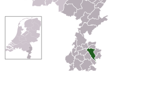
The Zaan is a small river in the province of North Holland in the northwestern Netherlands and the name of a district through which it runs. The river was originally a side arm of the IJ bay and travels 13.5 kilometers through the municipalities of Zaanstad and Wormerland north of Amsterdam, from West-Knollendam in the north to Zaandam in the south, where it empties into the IJ.
Holzlar Is an enclosed settlement in Bonn's district Beuel, east of the Rhine and north of the Siebengebirge in Germany. Holzlar has a population of about 11.000 and consists out of the former villages Holzlar, Kohlkaul, Heidebergen, Roleber and Gielgen.

Haydon Hill is part of the town of Aylesbury, England. The neighbourhood is to the north of Aylesbury, Buckinghamshire. It occupies the area to the north of the town and to the west of the A41, Bicester Road.

The River Menalhyl is a river in Cornwall, England, that flows through the civil parishes of St Columb Major and Mawgan-in-Pydar. Its length is about 12 miles and it flows in a generally north-west direction. The name comes from the Cornish words melyn meaning mill and heyl meaning estuary - estuary mills. The name was recorded as Mellynheyl in the 19th century, but it had been known as Glyvion.

Łagiewniki is a village in the administrative district of Gmina Chmielnik, within Kielce County, Świętokrzyskie Voivodeship, in south-central Poland. It lies approximately 4 km (2 mi) east of Chmielnik and 32 km (20 mi) south-east of the regional capital Kielce.

Rab'-e Rashidi was a tomb complex, including a school and workshop for producing books in the north-eastern part of the city of Tabriz, Iran, constructed in the early 14th century during the reign of Ghazan, a ruler of the Ilkhanid dynasty. Later other buildings replaced these, and the site is now ruined, but it is the original complex that gives the site its fame. It was founded and richly endowed by Rashid-al-Din Hamadani, the chief minister of Ghazan Khan. Rashid-al-Din sought to gather the most famous intellectuals of his time in fields of philosophy, science and medicine. The establishment started to decline after the execution of Rashid al din in 1318, though his son Ghiyas al-Din ibn Rashid al-Din led a revival in the 1330s, until his own murder in 1336.
Readington Village is an unincorporated community located within Readington Township in Hunterdon County, New Jersey, United States, that is centered on the converging of Readington Road, Hillcrest Road, Centerville Road and Brookview Road. It is located on Holland Brook, originally named Amanmechunk, which means large creek in the Unami dialect. The area was inhabited by the Raritan prior to the arrival of European settlers. The Native Americans who lived near Readington Village travelled to the coast during the summer for fish and clams. Such a trip is mentioned in an Indian deed transferring lands around Holland Brook to English and Dutch settlers. The deed mentions two of the natives, who lived at Readington: Metamisco and Wataminian.
The city of Leeuwarden, Friesland, the Netherlands has had at least 130 windmills over the centuries. Only one, the Froskepôlemolen survives today within Leeuwarden. Six other mills which have stood in Leeuwarden survive elsewhere in the Netherlands. The mills had a wide range of industrial and agricultural uses. The industrial uses include the processing of bark for tanning leather, the fulling of cloth, the production of cement, the production of dyes, the extraction of oil, the grinding of tobacco to produce snuff, the production of gunpowder, and the sawing of timber. Agricultural uses include the milling of buckwheat, oats, rye and wheat, the processing of chicory, the production of pearl barley, and the pumping of water.

Egem is a hamlet in the sub-municipality of Bambrugge in the municipality of Erpe-Mere in Flanders. It is located on the Molenbeek, in the Denderstreek, within the southeast of East Flanders and belongs to the Arrondissement of Aalst. It is bordered by the sub-municipalities of Bambrugge proper, Vlekkem, Ottergem and Zonnegem. Egem also borders the domain Steenberg. Egem consists of two streets, the Egemstraat and Everdal.
A Tjasker is a type of small drainage windmill used in the Netherlands. There are thirteen tjaskers remaining in Friesland.

De Akkermolen is a 17th-century windmill in Zundert, Netherlands. Built around 1605 to replace an earlier windmill, it was used as a gristmill until it was severely damaged in 1950. The mill was bought by the local government and restored in 1961, and it was listed as a national heritage site in 1974.
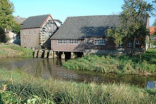
The Watermill at Opwetten is a watermill along the river Kleine Dommel, located on the Opwettenseweg 203 in Opwetten, Nuenen, Gerwen en Nederwetten, in the province of North Brabant, Netherlands. First mentioned in the 11th century, the watermill burned down and was rebuilt in 1764.