
The Vaal Dam in South Africa was constructed in 1938 and lies 77 km south of OR Tambo International Airport. The lake behind the dam wall has a surface area of about 320 square kilometres (120 sq mi) and is 47 meters deep. The Vaal Dam lies on the Vaal River, which is one of South Africa's strongest-flowing rivers. Other rivers flowing into the dam are the Wilge River, Klip River, Molspruit and Grootspruit. It has over 800 kilometres (500 mi) of shoreline and is South Africa's second biggest dam by area and the fourth largest by volume.
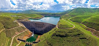
The Katse Dam, a concrete arch dam on the Malibamat'so River in Lesotho, is Africa's second largest double-curvature arch dam.. The dam is part of the Lesotho Highlands Water Project, which will eventually include five large dams in remote rural areas. The dam is just below the confluence of the Bokong River, which forms the western arm of the Katse reservoir.

The Vanderkloof Dam is situated approximately 130 km (81 mi) downstream from Gariep Dam and is fed by the Orange River, South Africa's largest river. Vanderkloof Dam is the second-largest dam in South Africa, having the highest dam wall in the country at 108 metres (354 ft). The dam was commissioned in 1977; it has a capacity of 3,187.557 million cubic metres (2,584,195 acre⋅ft) and a surface area of 133.43 square kilometres (51.52 sq mi) when full. Other rivers flowing into this dam are the Berg River, two unnamed streams coming in from the direction of Reebokrand, the Knapsak River, Paaiskloofspruit, Seekoei River, Kattegatspruit and the Hondeblaf River, in a clockwise direction.

Mohale Dam is a concrete faced rock-fill dam in Lesotho. It is the second dam, under Phase 1B of the series of dams of the proposed Lesotho Highlands Water Project (LHWP), which will eventually include five large dams in remote rural areas of Lesotho and South Africa. The project has been built at a cost of US$1.5 billion.

The Kilburn Dam, an earth-fill type dam and part of the Tugela-Vaal Water Project and Drakensberg Pumped Storage Scheme, is located 500 metres (1,600 ft) lower than the Sterkfontein Dam, on the Mnjaneni River, near Bergville, KwaZulu-Natal, province of South Africa. The dam was commissioned in 1981, has a capacity of 36,700 cubic metres (1,300,000 cu ft), and a surface area of 207 hectares, the dam wall is 48 metres (157 ft) high. The main purpose of the dam assembly is to serve for the generation of hydro-electricity and its hazard potential has been ranked high (3).

The Maguga Dam is a dam on the Komati River in Eswatini. It is 115 metres (377 ft) high and is located about 12 kilometres (7.5 mi) south of Piggs Peak. It was built as a joint project of the governments of South Africa and Eswatini. As of 2005, it was the largest public works project ever undertaken by Eswatini. The dam was completed in mid-2001.
The Albasini Dam is a dam located just outside the town of Louis Trichardt, Limpopo Province, South Africa. The dam has a capacity of 25,200,000 cubic metres (890,000,000 cu ft), and a surface area of 3.572 square kilometres (1.379 sq mi). The wall is 34 metres (112 ft) high.

The Kayacık Dam impounds the Ayfinar Deresi, one of the two streams that join south of Gaziantep to form the Sajur River. It is located in Gaziantep Province, Turkey. The dam was constructed between 1993 and 2005 as part of the Southeastern Anatolia Project. It is 45 metres (148 ft) high and has a volume of 1,853,000 cubic metres (65,400,000 cu ft). The reservoir created by the Kayacık Dam has a surface area of 11 square kilometres (4.2 sq mi) and a volume of 0.117 cubic kilometres (0.028 cu mi) and is used to irrigate an area of 200 square kilometres (77 sq mi).

Bloemhof Dam is a dam in South Africa. It was originally known as the Oppermansdrif Dam when under construction during the late 1960s. It is located at the confluence of the Vaal River and the Vet River, on the border between the provinces North West and Free State. The dam wall has a total length of 4,270 metres (14,010 ft) The reservoir is very shallow, and therefore needs a large area to mean anything for water storage. The area around the reservoir (dam), has been a protected area, but because it lies on the border between provinces, these became two separate nature reserves. On the North West Province side lies the Bloemhof Dam Nature Reserve, on the Free State side is the Sandveld Nature Reserve.
The Allemanskraal Dam is a dam in the Free State province of South Africa, on the Sand River. It was established in 1960. The reservoir has a gross capacity of 174,500 cubic metres (6,160,000 cu ft), and a surface area of 26.481 square kilometres (10.224 sq mi), the dam wall is 38 metres (125 ft) high.
Armenia Dam is a dam in the Leeu River, near Hobhouse, Free State province, South Africa. It was established in 1954. It has a capacity of 13,000 cubic metres (460,000 cu ft), and a surface area of 3.933 square kilometres (1.519 sq mi), the wall is 22 metres (72 ft) high.
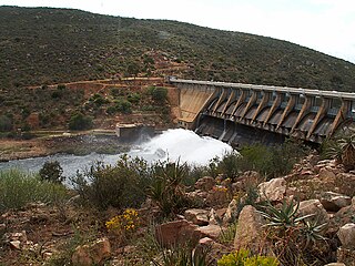
Clanwilliam Dam is a concrete gravity dam on the Olifants River, near Clanwilliam, Western Cape, South Africa. It was established in 1935, and the wall was raised to its current height of 43 metres (141 ft) in 1964. The main purpose of the dam is to provide irrigation water to the agricultural region downstream. It has a capacity of 121,800,000 cubic metres (4.30×10⁹ cu ft).
Darlington Dam, also referred to as Lake Mentz. is a gravity type dam situated in the Sundays River, near Kirkwood, in Eastern Cape, South Africa. It was established in 1922 and was renovated in 1952. The dam has a capacity of 187,000,000 cubic metres (6.6×10⁹ cu ft), with a 35.3 metres (116 ft)-high wall. Its primary purpose is for irrigation, industrial and domestic use.
Xonxa Dam, is a composite zoned earthfill/rockfill dam situated on the White Kei River in Eastern Cape, South Africa. It was established in 1972 and has a capacity of 158,500,000 cubic metres (5.60×10⁹ cu ft). The wall is 48 metres (157 ft) high. The dam serves mainly for irrigation purposes and its hazard potential has been ranked high (3).
Gamka River is a river located in the Western Cape, South Africa. The name 'Gamka' means 'Lion' and was probably named so by the San people (Bushmen). The river originates north of Beaufort West, generally flowing southwest towards the Gamkapoort Dam.
Bongolo Dam, is located on the Komani River, near Queenstown, Eastern Cape, South Africa. The dam has a capacity of 7,015,000 cubic metres (247,700,000 cu ft). The Bongolo Dam, about 5 kilometres (3.1 mi) from town on the Dordrecht road, is one of Queenstown's main sources of water, its main purpose is for industrial and municipal usage. The wall was begun in 1905 and was for years the largest concrete dam wall in South Africa. Incidentally the origin of the name Bongola has caused some controversy, but it is believed by some to have been derived from the Xhosa language word mbongolo meaning donkey, as these animals were extensively used in the construction of the dam.
Kommandodrif Dam is an earth-fill/rockfill type dam located on the Tarka River, near Cradock, Eastern Cape, South Africa. The dam has a capacity of 58,900,000 cubic metres (2.08×10⁹ cu ft), the wall is 38 metres (125 ft) high. The dam is included in the Commando Drift Nature Reserve and its main purpose is to serve for irrigation use. The hazard potential of the dam has been ranked high (3).
Nqweba Dam (previously known as Vanryneveld's Pass Dam), is an earth-fill type dam located on the Sundays River, near Graaff Reinet, in the Eastern Cape, South Africa. It was established in 1925. The dam has a capacity of 46,369,000 cubic metres (1.6375×10⁹ cu ft), and a surface area of 10.285 square kilometres (3.971 sq mi), the wall is 46 metres (151 ft), and is 357 metres (1,171 ft) long. Once an irrigation dam, it now mainly serves to supply potable water for domestic and industrial use to the residents and businesses of Graaff-Reinet. Its hazard potential has been ranked high (3).
Ben Chifley Dam, or Chifley Dam, is a rock and earth-fill embankment dam across the Campbells River in the central west region of New South Wales, Australia. The main purpose of the dam is to supply potable water to the city of Bathurst.

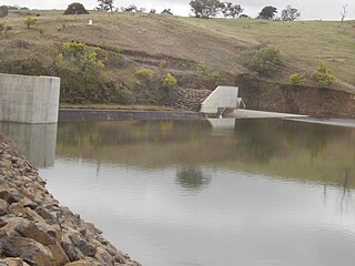
Fitzroy Falls Dam in New South Wales, Australia, is part of the Shoalhaven Scheme, completed in 1974. It consists of four separate earth and rockfill embankments located on the Yarrunga Creek upstream of Fitzroy Falls and about 16 kilometres (9.9 mi) southeast of Moss Vale. The main embankment of 760 cubic metres (27,000 cu ft) is 14 metres (46 ft) high and 1,530 metres (5,020 ft) in length. At 100% capacity, the dam wall holds back approximately 9,950 megalitres of water, creating the impounded Fitzroy Falls Reservoir, which has a surface area of 522 hectares, drawn from a catchment area of 31 square kilometres (12 sq mi). The spillway has a discharge capacity of 516 cubic metres per second (18,200 cu ft/s).


