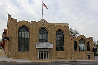
The Sokol Auditorium is located at 2234 South 13th Street in the Little Bohemia neighborhood of South Omaha, Nebraska. It is a local icon for its historical context, as well as modern musical performances and gymnastics. It has a maximum capacity of 1,500.

North Omaha is a community area in Omaha, Nebraska, in the United States. It is bordered by Cuming and Dodge Streets on the south, Interstate 680 on the north, North 72nd Street on the west and the Missouri River and Carter Lake, Iowa on the east, as defined by the University of Nebraska at Omaha and the Omaha Chamber of Commerce.

Culture in North Omaha, Nebraska, the north end of Omaha, is defined by socioeconomic, racial, ethnic and political diversity among its residents. The neighborhood's culture is largely influenced by its predominantly African American community.
The Country Club Historic District is located in Omaha, Nebraska from 50th to 56th Streets, from Corby to Seward Streets. With dozens of homes built between 1925 and 1949 in the late 19th and 20th Century Revival styles, the community was added to the National Register of Historic Places in 2004.

Field Club is a neighborhood located in the Midtown region of Omaha, Nebraska. Roughly bounded by Pacific Street, 32nd Avenue, Center St., and 36th Street, the neighborhood was placed on the National Register of Historic Places as a historic district on November 15, 2000. Field Club is the location of dozens of historically significant homes in the Omaha area, including the Gerald R. Ford Birthsite and Gardens.
The Omaha Black Music Hall of Fame, or the OBMHoF, is a nonprofit organization founded in 2005 to celebrate, document and honour the legacy of the many top vocalists and musicians whose musical careers began in the metropolitan area of Omaha, Nebraska. It has a particular focus on African American music from North Omaha, and is committed to honoring Omaha's blues tradition from the 1920s to the present day. The OBMHoF holds induction ceremonies every two years that highlight, but are not limited to, classical, rhythm & blues, big band, jazz and gospel music.

The Bemis Park Landmark Heritage District is located in North Omaha, Nebraska. Situated from Cuming Street to Hawthorne Avenue, Glenwood Avenue to 33rd Street, Bemis Park was annexed into Omaha in 1887, and developed from 1889-1922. The district was designated an Omaha Landmark in 1983.
The Near North Side of Omaha, Nebraska is the neighborhood immediately north of downtown. It forms the nucleus of the city's African-American community, and its name is often synonymous with the entire North Omaha area. It is bordered by Cuming Street on the south, 30th on the west, 16th on the east, and Locust Street to the north.

The culture of Omaha, Nebraska, has been partially defined by music and college sports, and by local cuisine and community theatre. The city has a long history of improving and expanding on its cultural offerings. In the 1920s, the Omaha Bee newspaper wrote, "The cultural future of Omaha seems as certain of greatness as the commercial future... The symphony orchestra, the Art institute, the Community Playhouse and other organizations are on firm foundations and Omaha is destined to be not only a bigger, but a better city, both financially and culturally." Reviewing Omaha's contemporary arts scene in 2007, the New York Times hailed the city as having "a kind of cultural awakening".
Scriptown was the name of the first subdivision in the history of Omaha, which at the time was located in Nebraska Territory. It was called "Scriptown" because scrip was used as payment, similar to how a company would pay employees when regular money was unavailable. Its original survey placed the location from the Missouri River to North 30th Street, Cuming to Fort Street.
Forest Lawn Memorial Park, also known as Forest Lawn Cemetery, is located at 7909 Mormon Bridge Road in Omaha, Nebraska. It was established in 1885 when the Forest Lawn Cemetery Association was donated 100 acres (0.40 km2) in northwest of the city. In 1886, the first interment in the cemetery was the donor of the land, John H. Brackin. Forest Lawn is Omaha's largest cemetery and the burial location of many of Omaha's second generation of leadership.
The Vinton Street Commercial Historic District is located along Vinton Street between Elm Street on the west and South 17th Street on the east in south Omaha, Nebraska. This district is located adjacent to Sheelytown, a residential neighborhood that had historically significant populations of Irish, Poles, and Eastern European immigrants. It grew along with the success of the Union Stockyards and South Omaha. It was added to the National Register of Historic Places in 2006.
Fontenelle Boulevard is a roadway in the Omaha boulevard system located on the north end of Omaha, Nebraska. The boulevard shares its namesake Logan Fontenelle with several local institutions and fixtures, including Fontenelle Elementary School and Fontenelle Park.
Lincoln Boulevard in Omaha, Nebraska was built in the early 1890s as part of the city's boulevard system under control of the Board of Park Commissioners. It runs through the Bemis Park neighborhood west-east from Mercer Boulevard to its end at North 29 Street; it then reemerges immediately north of Dodge Street, where it intersects with Turner Boulevard.
The Florence School is located at 7902 North 36th Street in the Florence neighborhood of north Omaha, Nebraska, United States. The first school in the Florence area was built in the 1840s, in what was then called Cutler's Park by Mormon pioneers. The present-day Florence Elementary School was started in the late 1850s after the town of Florence was founded.
Salem Baptist Church is located at 3131 Lake Street in north Omaha, Nebraska, United States. Founded in 1922, it has played important roles in the history of African Americans in Omaha, and in the city's religious community. Church leadership has impacted the city in a variety of ways, with long-time pastor Rev. J.C. Wade being recognized in the Congressional Record in 2000, and having an area post office named after him.
The Wilson Packing Plant was a division of the Wilson and Company meatpacking company located near South 27th and Y Streets in South Omaha, Nebraska. Founded in the 1890s, it closed in 1976. It occupied the area bounded by Washington Street, South 27th Street, W Street and South 30th Street. Located on the South Omaha Terminal Railway and next to the Omaha Stockyards, Wilson was regarded as one of the "Big Four" packing companies in Omaha.
Love's Jazz and Art Center is located at 2510 North 24th Street in the Near North Omaha neighborhood of Omaha, Nebraska. Founded and named to honor of Omaha jazz great Preston Love, Love's highlights the African American culture of North Omaha. In addition to sponsoring a variety of events, Love's has hosted events for Native Omaha Days.
Honey Creek is a stream in Pottawattamie and Harrison counties, Iowa, in the United States. It is a tributary of Missouri River.