Ontonagon Harbor Piers Historic District

Last updated
Ontonagon Harbor Piers Historic District
Ontonagon Harbor.jpg
USA Michigan location map.svg
Red pog.svg
Usa edcp location map.svg
Red pog.svg
Location Ontonagon R. at Lake Superior, Ontonagon, Michigan
Coordinates 46°52′36″N89°18′39″W / 46.87667°N 89.31083°W / 46.87667; -89.31083 Coordinates: 46°52′36″N89°18′39″W / 46.87667°N 89.31083°W / 46.87667; -89.31083
Area 16 acres (6.5 ha)
Built 1868 [1]
Architect US Army Corps of Engineers
NRHP reference # 01001313 [2]
Added to NRHP December 4, 2001

The Ontonagon Harbor Piers Historic District is historic shipping structure located on the Ontonagon River at Lake Superior in Ontonagon, Michigan. It was listed on the National Register of Historic Places in 2001. [2]

Ontonagon River river in Michigan

The Ontonagon River is a river flowing to Lake Superior on the western Upper Peninsula of Michigan in the United States. The main stem of the river is 25 miles (40 km) long and is formed by a confluence of several longer branches, portions of which have been collectively designated as a National Wild and Scenic River. Several waterfalls occur on the river including Agate Falls and Bond Falls.

Lake Superior largest of the Great Lakes of North America

Lake Superior, the largest of the Great Lakes of North America, is also the world's largest freshwater lake by surface area, and the third largest freshwater lake by volume. The lake is shared by the Canadian province of Ontario to the north, the U.S. state of Minnesota to the west, and Wisconsin and the Upper Peninsula of Michigan to the south. The farthest north and west of the Great Lakes chain, Superior has the highest elevation of all five great lakes and drains into the St. Mary's River.

Ontonagon, Michigan Village in Michigan, United States

Ontonagon is a village in the U.S. state of Michigan. The population was 1,494 at the 2010 census. It is the county seat of Ontonagon County.

Contents

Diagram of piers Ontonagon pier diagram.jpg
Diagram of piers

History

In 1860, the Army Corps of Engineers began designing pier structures in Ontonagon at the mouth of the river. [3] The initial construction of the Ontonagon piers was carried out during 1868-1872 [1] The inner 1069 feet of the west pier, constructed of wood pilings filled with stone, dates from this time. [1] Over the next 20 years, another 1770 feet of the east pier and 1398 feet of the west pier was constructed, [1] and a pierhead light was installed on the west pier. [3] In addition, the inner 545 ft of the east pier was reconstructed; all of these pier structures were of rock-filler timber cribs. [1]

United States Army Corps of Engineers federal agency under the Department of Defense and a major Army command

The United States Army Corps of Engineers (USACE) is a U.S. federal agency under the Department of Defense and a major Army command made up of some 37,000 civilian and military personnel, making it one of the world's largest public engineering, design, and construction management agencies. Although generally associated with dams, canals and flood protection in the United States, USACE is involved in a wide range of public works throughout the world. The Corps of Engineers provides outdoor recreation opportunities to the public, and provides 24% of U.S. hydropower capacity.

In the 1920 and 1930s, a stone superstructure was built over sections of both piers, and a concrete cap was constructed on the inner 1,069 feet of the west pier. In 1947, the west pierhead was rebuilt, and in 1883 various structural improvements were made. [1]

Description

The shipping channel between the piers is 150 feet wide and 15–17 feet deep. [4] The east and west entrance piers are 2,315 feet and 2,563 feet long, respectively. A flared approach channel extends 850 feet to deep water. The inner basin is 900 feet long and 12 feet deep. The Ontonagon harbor is the only refuge for small craft between the Keweenaw Waterway upper entrance and Black River Harbor. [4]

Harbor pier images

Related Research Articles

Indiana Harbor and Ship Canal canal indiana, United States of America

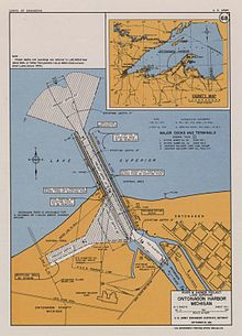
The Indiana Harbor and Ship Canal is an artificial waterway on the southwest shore of Lake Michigan, in East Chicago, Indiana, which connects the Grand Calumet River to Lake Michigan. It consists of two branch canals, the 1.25 mile (2 km) Lake George Branch and the 2 mile (3 km) long Grand Calumet River Branch which join to form the main Indiana Harbor Canal.

Mississippi River–Gulf Outlet Canal canal in Louisiana, United States of America

The Mississippi River – Gulf Outlet Canal is a 76 mi (122 km) channel constructed by the United States Army Corps of Engineers at the direction of Congress in the mid-20th century that provided a shorter route between the Gulf of Mexico and New Orleans' inner harbor Industrial Canal via the Intracoastal Waterway. In 2005, although disputed by the Corps of Engineers, the MRGO channeled Hurricane Katrina's storm surge into the heart of Greater New Orleans, contributing significantly to the subsequent multiple engineering failures experienced by the region's hurricane protection network. In the aftermath the channel was closed. A permanent storm surge barrier was constructed in the MRGO in 2009, and the channel has been closed to maritime shipping.

Charlevoix South Pier Light Station lighthouse in Michigan, United States

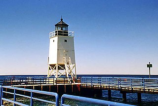
The Charlevoix South Pier Light Station is located on Lake Michigan at the entrance to Lake Charlevoix in Charlevoix County in the U.S. state of Michigan at the end of the south pier/breakwater of the channel leading to Round Lake in the city of Charlevoix.

St. Clair Flats Front and Rear Range Light lighthouse in Michigan, United States

St. Clair Flats Front and Rear Range Light are two lighthouse structures situated off the southeastern tip of Harsens Island at Lake St. Clair.

Manistique East Breakwater Light lighthouse in Michigan, United States

The Manistique Breakwater lighthouse is located in the harbor of Manistique, Michigan. It was listed on the National Register of Historic Places in 2005.

Muskegon Pier Light lighthouse in Michigan, United States

The Muskegon South Pierhead Light or Muskegon Pier Light is a lighthouse located on the channel in the harbor of Muskegon, Michigan.

Port Washington Breakwater Light lighthouse on Lake Michigan in Port Washington, Wisconsin, United States

The Port Washington Breakwater Light is a lighthouse built in 1935 at the entrance to the Port Washington, Wisconsin harbor on Lake Michigan. The second tower at this location, it remains an active aid to navigation. It was listed on the National Register of Historic Places in 2018.

Green Bay Harbor Entrance Light lighthouse in Wisconsin, United States

The Green Bay Harbor Entrance Light is an offshore lighthouse near Green Bay, Wisconsin. Located 10 miles (16 km) from the mouth of the Fox River, it was erected to signal the entrance to Green Bay.

Grand Marais Harbor of Refuge Inner and Outer Lights lighthouse in Michigan, United States

The Grand Marais Harbor of Refuge Inner and Outer Lights are a pair of lighthouses located on the west pier at the entry to Grand Marais Harbor of Refuge, in Grand Marais, Michigan. They were listed on the National Register of Historic Places in 2012.

Navigation Structures at Pentwater Harbor

The Navigation Structures at Pentwater Harbor are navigational structures located at the west end of Lowell Street in Pentwater, Michigan. They were listed on the National Register of Historic Places in 2001.

Navigation Structures at Frankfort Harbor

The Navigation Structures at Frankfort Harbor are a collection of breakwaters, piers, and other structures in Lake Michigan located at the foot of Second Street in Frankfort, Michigan. They were listed on the National Register of Historic Places in 1997.

Grand Haven South Pierhead Inner Light lighthouse in Michigan, United States

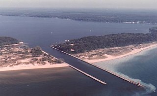
Grand Haven South Pierhead Inner Light is the inner light of two lighthouses on the south pier of Grand Haven, Michigan where the Grand River enters Lake Michigan. A lighthouse was first lit there in 1839. The lighthouse was put up for sale in 2009 under the National Historic Lighthouse Preservation Act. The City of Grand Haven now owns the pier, but it is maintained by the Army Corps of Engineers.

Keweenaw Waterway Lower Entrance Light

The Keweenaw Waterway Lower Entrance Light, also known as the Portage Entry Light, is a lighthouse located at the south end of breakwater at mouth of the Portage River in Torch Lake Township. It was listed on the National Register of Historic Places in 2014.

Keweenaw Waterway Upper Entrance Light lighthouse in Michigan, United States

The Keweenaw Waterway Upper Entrance Light is a lighthouse located at the north end of the Portage River in McLain State Park in Hancock Township, Michigan. It was listed on the National Register of Historic Places in 2014.

Navigation Structures at Saugatuck Harbor

The Navigation Structures at Saugatuck Harbor consist of two piers flanking the mouth of the Kalamazoo River on the shore of Lake Michigan near Saugatuck, Michigan. The structures were listed on the National Register of Historic Places in 2001.

Manistee Harbor, South Breakwater

The Manistee Harbor, South Breakwater is a navigational structure located at the mouth of the Manistee River, in Manistee, Michigan. It was listed on the National Register of Historic Places in 1995. The breakwater is significant due to its construction, which represents a final stage in the United States Army Corps of Engineers's use of timber crib substructures in pier and breakwater construction.

Navigation Structures at White Lake Harbor

The Navigation Structures at White Lake Harbor area set of piers protecting the channel connecting Lake Michigan and White Lake, located at the end of Lau Road near Whitehall, Michigan. It was listed on the National Register of Historic Places in 2000.

Piers and Revetments at Grand Haven, Michigan

The Piers and Revetments at Grand Haven, Michigan are navigational structures located at the mouth of the Grand River in Grand Haven, Michigan. The structures were listed on the National Register of Historic Places in 1995.

Navigation Structures at Harbor Beach Harbor

The Navigation Structures at Harbor Beach Harbor are a series of breakwaters located in Lake Huron, on North Lakeshore Drive in Harbor Beach, Michigan. They were listed on the National Register of Historic Places in 1997.

References

  1. 1 2 3 4 5 6 Robert R Bottin Jr (June 1988), CASE HISTORIES OF CORPS BREAKWATER AND JETTY STRUCTURES, Report 3, North Central Division (PDF), Coastal Engineering Research Center, Waterways Experiment Station, Army Corps of Engineers, pp. 11, 55–59
  2. 1 2 National Park Service (2010-07-09). "National Register Information System". National Register of Historic Places . National Park Service.
  3. 1 2 Terry Pepper. "Ontonagon Pierhead Light". Seeing the Light. Retrieved December 17, 2011.
  4. 1 2 "Ontonagon Harbor, Michigan (Project Overview)". US Army Corps of Engineers. Retrieved December 17, 2011.