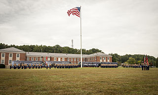
Marine Corps Base Quantico is a United States Marine Corps installation located near Triangle, Virginia, covering nearly 55,148 acres (86.169 sq mi) of southern Prince William County, Virginia, northern Stafford County, and southeastern Fauquier County. Used primarily for training purposes, MCB Quantico is known as the "Crossroads of the Marine Corps".

Prince William Forest Park was established as Chopawamsic Recreational Demonstration Area in 1936. Its location is in Triangle, Virginia, adjacent to the Marine Corps Base Quantico. The park is the largest protected natural area in the Washington, D.C. metropolitan region at over 16,000 acres (6,500 ha). Today, the park is a window into the past and serves as an example of what much of the East Coast once looked like centuries ago.

First Landing State Park offers recreational opportunities at Cape Henry in the independent city of Virginia Beach, Virginia. As the first planned state park of Virginia, First Landing is listed on the National Register of Historic Places as Seashore State Park Historic District. A portion of the park is listed as a National Natural Landmark as part of the Seashore Natural Area.
Raccoon Creek State Park is a 7,572-acre (3,064 ha) Pennsylvania state park on Raccoon Creek in Hanover and Independence townships in Beaver County, Pennsylvania in the United States. The park is about 30 miles (48 km) from the city of Pittsburgh, near Hookstown. Raccoon Creek State Park is easily accessed from Pennsylvania Route 18 and U.S Routes 30 and 22. The park offers numerous activities such as hiking, biking, cross-country skiing, camping, swimming, fishing, and boating, the last three at the 101-acre (41 ha) "Raccoon Lake."

Laurel Hill State Park is a 3,935-acre (1,592 ha) Pennsylvania state park in Jefferson and Middlecreek Townships, Somerset County, Pennsylvania in the United States. Laurel Hill Lake is a 63-acre (25 ha) man-made lake with a dam that was constructed during the Great Depression by the young men of CCC camps SP-8-PA and SP-15-PA. Laurel Hill State Park is 8 miles (13 km) from Interstate 76 just off Pennsylvania Route 31 near Bakersville and on Pennsylvania Route 653 near Trent.

Backbone State Park is Iowa's oldest state park, dedicated in 1919. Located in the valley of the Maquoketa River, it is approximately three miles (5 km) south of Strawberry Point in Delaware County. It is named for a narrow and steep ridge of bedrock carved by a loop of the Maquoketa River originally known as the Devil's Backbone. The initial 1,200 acres (490 ha) were donated by E.M. Carr of Lamont, Iowa. Backbone Lake Dam, a relatively low dam built by the Civilian Conservation Corps (CCC) in the 1930s, created Backbone Lake. The CCC constructed a majority of trails and buildings which make up the park.

Lake of the Ozarks State Park is a Missouri state park on the Grand Glaize Arm of the Lake of the Ozarks and is the largest state park in the state. This is also the most popular state park in Missouri, with over 2.5 million visitations in 2017.

Westmoreland State Park lies within Westmoreland County, Virginia. The park extends about one and a half miles along the Potomac River and covers 1,321 acres. The Horsehead Cliffs provide visitors with a panoramic view of the Potomac River, and lower levels feature fossils and beach access. The park offers hiking, camping, cabins, fishing, boating and swimming, although mechanical issues in 2021 kept the swimming facility closed. Located on the Northern Neck Peninsula, the park is close to historical sites featuring earlier eras: George Washington's birthplace and Stratford Hall, the birthplace of Robert E. Lee.

This is a list of the National Register of Historic Places listings in Prince William County, Virginia.

Zoar is a historic farmstead and national historic district located within Zoar State Forest near the Aylett community of King William County, Virginia, United States. It is also known as Mount Zoar, Upper Zoar, and Lower Zoar. The district encompasses 6 contributing buildings and 2 contributing sites. The main house was built in 1901, and is a 1 1/2-story Queen Anne style single-family frame dwelling. Associated with the house are the contributing smokehouse, kitchen / servant's quarters, dairy, corn crib and barn, horsefield, and family cemetery.

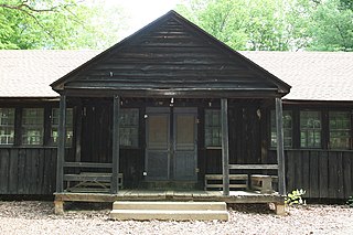
The Goodwill Historic District, Chopawamsic RDA Camp 1 near Triangle, Virginia dates from 1934. It has also been known as Prince William Forest Park, as Camp Lichtman, and as Boys' Camp. It was listed as a historic district on the National Register of Historic Places on June 12, 1989. The listing included eight contributing buildings, one contributing structure and one contributing site on 13 acres (5.3 ha).

The Mawavi Historic District, Chopawamsic RDA Camp 2 near Triangle, Virginia, United States, dates from 1942. It was listed on the National Register of Historic Places in 1989.
The Pleasant Historic District, Chopawamsic RDA Camp 4 near Triangle, Virginia dates from 1934. It was listed on the National Register of Historic Places in 1989. It includes NPS rustic architecture and is within what is now Prince William Forest Park. The listing included 36 contributing buildings and three contributing structures on 132 acres (53 ha).
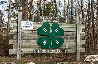
Holiday Lake 4-H Educational Center, also known as Surrender Grounds Forest and Holiday Lake 4-H Camp, is located within the confines of Appomattox-Buckingham State Forest near Appomattox, Appomattox County, Virginia.

Brentsville Historic District is a national historic district located near Bristow, at Brentsville, Prince William County, Virginia. It encompasses 23 contributing buildings and 2 contributing sites in the village of Brentsville platted in 1822. These include the former Brentsville Courthouse and Jail, a one-room school (1928), three churches, 11 houses, one ruins of a dwelling, a tavern square site, and 14 outbuildings.

Buckland Historic District is a national historic district located at Buckland, Prince William County, Virginia. It encompasses 30 contributing buildings, 11 contributing sites, and 6 contributing structures in the town of Buckland. The district is centered on a grist mill, Buckland Mill, the third such structure located on the site. Besides the mill, the most significant buildings include an early 19th-century wagon tavern and a small church. For the most part the houses are small, simple, 19th-century dwellings constructed of log, frame or stone; most were intended to serve a commercial as well as a residential purpose. Other contributing resources include the mill race and dam, Cerro Gordo plantation, portions of the Civil War Buckland battlefields, the Kinsley Mill and miller's house, and Buckland Hall.

Occoquan Historic District is a national historic district located at Occoquan, Prince William County, Virginia. It encompasses 60 contributing buildings in the town of Occoquan. The buildings are predominantly frame, two-story, residential structures although the earliest examples are constructed of stone or brick. The Ellicott's Mill House houses Historic Occoquan, Inc. The district also includes several notable non-residential buildings including the Hammill Hotel, Ebenezer Church (1924), Methodist Church (1926), and Crescent Lodge #3 (1889). Located in the district is the separately listed Rockledge.

Cabin Branch Pyrite Mine Historic District is a national historic district located at Prince William Forest Park, Triangle, Prince William County, Virginia. It encompasses 4 contributing sites and 42 contributing structures associated with the Cabin Branch pyrite mine. The pyrite mine opened in 1889, and remained in operation until 1919 or 1920. The property includes a number of capped mine shafts, and the remains of a commissary building and an old mill; and mine structures, including crusher house, mill, mechanical and support buildings, numerous rail lines.

Old Town Manassas, or the Manassas Historic District, is a national historic district located at Manassas, Virginia. It encompasses 206 contributing buildings and 1 contributing object in the central business district and surrounding residential area of city of Manassas.

Upton State Forest is a publicly owned forest with recreational features primarily located in the town of Upton, Massachusetts, with smaller sections in the towns of Hopkinton and Westborough. The state forest encompasses nearly 2,800 acres (1,100 ha) of publicly accessible lands and includes the last remaining Civilian Conservation Corps (CCC) camp in Massachusetts, built in Rustic style. The CCC campground was listed on the National Register of Historic Places in 2014.


