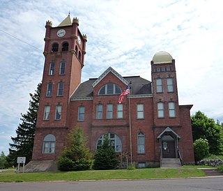
Lake County is a county in the U.S. state of Minnesota. As of the 2010 United States Census, the population was 10,866. Its county seat is Two Harbors.
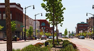
Superior is a city in, and the county seat of, Douglas County in the state of Wisconsin. The population was 27,244 at the 2010 census. Located at the junction of U.S. Highway 2 and U.S. Highway 53, it is immediately north of and adjacent to both the Village of Superior and the Town of Superior. Its neighborhoods include Billings Park, North End, South Superior, Central Park, East End, Allouez, and Itasca. Billings Park, South Superior, East End, and North End each have small business districts.
Presque Isle may refer to:

M-26 is a 96.355-mile-long (155.068 km) state trunkline highway in the U.S. state of Michigan, running from two miles (3.2 km) east of Rockland to its junction with US Highway 41 (US 41) in Copper Harbor. It generally runs southwest-to-northeast in the western half or Michigan's Upper Peninsula. The northernmost segment, which closely parallels the shore of Lake Superior on the west side of the Keweenaw Peninsula, is highly scenic.

The Montreal River is a river flowing to Lake Superior in northern Wisconsin and the Upper Peninsula of Michigan in the United States. It is 47.8 miles (76.9 km) long and drains approximately 270 square miles (700 km2) in a forested region. For most of its length, the river's course defines a portion of the Wisconsin–Michigan border. The Ojibwe name for the river is Gaa-waasijiwaang, meaning "where there is whitewater".
Minnesota State Highway 61 is a highway in northeast Minnesota, which runs from a junction with Interstate 35 (I-35) in Duluth at 26th Avenue East, and continues northeast to its northern terminus at the Canadian border near Grand Portage. The roadway becomes Ontario Highway 61 upon entering Canada at the Pigeon River Bridge, and terminates at the Trans-Canada Highway in Thunder Bay. MN 61 is 149 miles (240 km) in length.

The North Shore of Lake Superior runs from Duluth, Minnesota, United States, at the southwestern end of the lake, to Thunder Bay and Nipigon, Ontario, Canada, in the north to Sault Ste. Marie, Ontario, in the east. The shore is characterized by alternating rocky cliffs and cobblestone beaches, with forested hills and ridges through which scenic rivers and waterfalls descend as they flow to Lake Superior.
Saxon Harbor is located on Lake Superior's Oronto Bay in Iron County, Wisconsin, United States. The harbor, adjacent to Oronto Creek, is a part of a county park that includes deep sea fishing, camping and a sandy beach stretching for four miles westward. Historically, this was near the beginning of an ancient Native American trade route known as the Flambeau Trail and was the site of a fur trading post operated by John Jacob Astor's American Fur Company from 1808 to 1830.

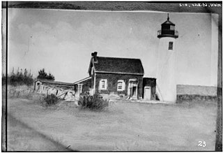
The Wisconsin Point Light is a lighthouse located near Superior, on Wisconsin Point, in Douglas County, Wisconsin, United States.

Minnesota Point, also known as the Park Point neighborhood of Duluth, Minnesota, United States; is a long, narrow sand spit that extends out from the Canal Park tourist recreation-oriented district of the city of Duluth. The Point separates Lake Superior from Superior Bay and the Duluth Harbor Basin.

Nicolas Perrot (c.1644–1717), a French explorer, fur trader, and diplomat, was one of the first European men to travel in the Upper Mississippi Valley, in what is now Wisconsin and Minnesota.

Superior Falls is a waterfall situated on the Montreal River, which forms the border between Iron County, Wisconsin and Gogebic County, Michigan, United States. The falls drop 90 feet (27 m) before the Montreal River empties into Lake Superior at Oronto Bay.
Superior Bay is a narrow inlet of Lake Superior along the border of Minnesota and Wisconsin. It is 7 miles long and 0.5 miles wide. A small strait connects it to the Saint Louis Bay to the west, into which the Saint Louis River empties. Superior Bay is located between the city of Superior and the Park Point neighborhood of Duluth. The Duluth Harbor Basin is nearby.

The Gogebic Range is an elongated area of iron ore deposits located within a range of hills in northern Michigan and Wisconsin just south of Lake Superior. It extends from Lake Namakagon in Wisconsin eastward to Lake Gogebic in Michigan, or almost 80 miles. Though long, it is only about a half mile wide and forms a crescent concave to the southeast. The Gogebic Range includes the communities of Ironwood in Michigan, plus Mellen and Hurley in Wisconsin.
The Oronto Group is a thick group of arkose sandstone and shale located beneath the Bayfield Group in northern Wisconsin, along the northwestern side of the Keweenaw Peninsula and southern Isle Royale, and believed to extend into Minnesota. Because it is almost entirely red in color and highly tilted, it is considered separate from the Bayfield Group. The Oronto Group is divided into the Copper Harbor Conglomerate, Freda Sandstone, and Nonesuch Shale. As the group is devoid of fossils, its age is difficult to ascertain, though it may be of Keweenawan Age.
The Minnesota Point Light was a historic lighthouse on Minnesota Point in Duluth, Minnesota, United States, on the shores of Lake Superior. Built in 1858, it was the first lighthouse in the state, but is now a truncated ruined tower. The ruin was listed on the National Register of Historic Places in 1974 for its state-level significance in the theme of transportation. It was nominated for being the first high-powered lighthouse on Lake Superior, and the zero-point for all original surveys of the lake.

The Duluth Ship Canal is an artificial canal cut through Minnesota Point, providing direct access to Duluth harbor from Lake Superior. Begun privately in 1871, it was put under federal supervision and maintenance several years later. It is still an important component of the harbor facilities.
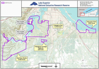
The Lake Superior National Estuarine Research Reserve is located along the St. Louis River in Douglas County, the northwest corner of Wisconsin, United States. It is one of many National Estuarine Research Reserves. It has an area of 16,697 acres (6,757 ha), and was designated in 2010.