
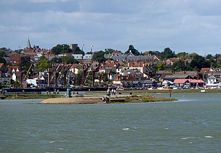
Burnham-on-Crouch is a town and civil parish in the Maldon District of Essex, in the East of England; it lies on the north bank of the River Crouch. It is one of Britain's leading places for yachting.
Maldon District is a local government district in Essex, England. The district is managed by Maldon District Council, which is based in Maldon, the largest town in the district. The district also includes the town of Burnham-on-Crouch and numerous villages, including Heybridge, Wickham Bishops, Southminster, Tolleshunt D'Arcy and Tollesbury. The district covers the Dengie peninsula to the south of Maldon and the Thurstable Hundred area to the north of the Blackwater Estuary, a total area of 358.78 km2.

Dengie is a peninsula in Essex, England, that once formed a hundred of the same name . The peninsula is formed by the River Crouch to the south, the Blackwater to the north, both of which are tidal, and the North Sea to the east. The eastern part of the peninsula is marshy and forms the Dengie Marshes.

Maldon is a constituency in Essex represented in the House of Commons of the UK Parliament since its recreation in 2010 by Sir John Whittingdale, a Conservative.
The Royal Burnham Yacht Club was founded in 1895. The club is located in Burnham-on-Crouch, England. The RBYC is divided into two groups of members: the cadets nineteen and younger, and the full members who are over nineteen. The club has a colourful history, including the launching of the 1983 Americas Cup Challenge: Victory Challenge. The Club has established relations with the Yacht Club De Monaco. With a team racing event that was held in Monaco for 8 cadets in April 2006. The RBYC also has the largest fleet of RS Elite in the country.

The Royal Corinthian Yacht Club is a watersports organisation based at Burnham-on-Crouch, Essex.
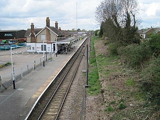
Burnham-on-Crouch railway station is on the Crouch Valley Line in the East of England, serving the town of Burnham-on-Crouch, Essex. It is 43 miles 24 chains (69.68 km) down the line from London Liverpool Street and is situated between Althorne to the west and Southminster to the east. The Engineer's Line Reference for the line is WIS; the station's three-letter station code is BUU. The platform has an operational length for eight-coach trains. It is located near the Mangapps Railway Museum.
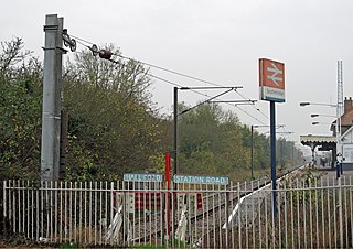
Southminster railway station is the eastern terminus of the Crouch Valley Line in Essex, England, serving the town of Southminster and other settlements on the Dengie Peninsula. It is 45 miles 42 chains (73.27 km) down the line from London Liverpool Street. The station is managed by Greater Anglia who operate all services. The Engineer's Line Reference for the line is WIS, the station's three-letter station code is SMN. The platform has an operational length for 8 carriages. The preceding station to the west is Burnham-on-Crouch.

The River Crouch is a small river that flows entirely through the English county of Essex.

Southminster is a village and civil parish on the Dengie Peninsula in the Maldon district of Essex in the East of England. It lies about 3 miles (4.8 km) north of Burnham-on-Crouch and 10 miles (16 km) south-east of Maldon; it is approximately 52 miles (84 km) east-north-east of London. To the north is the River Blackwater, which is tidal, and, since Roman times, has been the gateway to trading in the area.

Creeksea is a village and former civil parish, now in the parish of Burnham-on-Crouch, in the Maldon district, in the county of Essex, England. It is on the Dengie peninsula on the north side of the River Crouch, one mile west of Burnham-on-Crouch. In 1931 the parish had a population of 76.

Ormiston Rivers Academy is a secondary school and sixth form with academy status located in Burnham-on-Crouch, Essex, England.
The Burnham-on-Crouch and District Museum, located in Burnham-on-Crouch, Essex, is a registered charity run by members of the Burnham History Society, aiming to reflect the history and development of the town and the local people.

The Crouch and Roach Estuaries are a 1729 hectare biological Site of Special Scientific Interest (SSSI) at the mouth of the Crouch and Roach rivers in Essex. The Crouch part of the SSSI stretches from near Battlesbridge to Foulness Island, and the Roach from Rochford to the junction with the Crouch. Part of the site is in the Mid-Essex Coast Special Protection Area under the EC Directive on the Conservation of Wild Birds, and a Ramsar wetland site of international importance. It is also part of the Essex Estuaries Special Area of Conservation. An area of 65 hectares is managed by the Essex Wildlife Trust as the Lion Creek and Lower Raypits nature reserve and 8 hectares at Woodham Fen, both of which are managed by the Essex Wildlife Trust. A small area is also a geological SSSI, The Cliff, Burnham-on-Crouch.
The Cadet World Championship are international sailing regattas in the Cadet class organized by the International Sailing Federation and the International Cadet Class Association.

The Cliff, Burnham-on-Crouch is a 4 hectare geological Site of Special Scientific Interest (SSSI) on the bank of the River Crouch between Burnham-on-Crouch and North Fambridge in Essex. It is also part of the biological SSSI, Crouch and Roach Estuaries. It is a Geological Conservation Review site both for its fossil birds and for its fishes and amphibians.

Blue House Farm is a 242.8-hectare (600-acre) nature reserve and farm in North Fambridge, on the north bank of the River Crouch between Burnham-on-Crouch and South Woodham Ferrers in Essex. It is managed by the Essex Wildlife Trust. Most of the site is in of the Crouch and Roach Estuaries Site of Special Scientific Interest.

Woodham Fen is an 8.1-hectare (20-acre) nature reserve in South Woodham Ferrers in Essex. It is managed by the Essex Wildlife Trust. It is part of the Crouch and Roach Estuaries Site of Special Scientific Interest.
