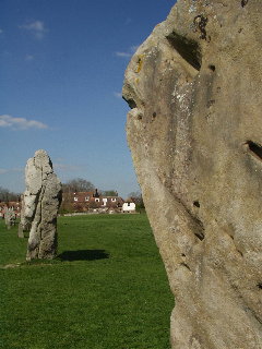
Avebury is a village and civil parish in Wiltshire, England. The village is about 5.5 miles (9 km) west of Marlborough and 8 miles (13 km) northeast of Devizes. Much of the village is encircled by the prehistoric monument complex also known as Avebury. The parish also includes the small villages of Avebury Trusloe and Beckhampton, and the hamlet of West Kennett.

Wansdyke is a series of early medieval defensive linear earthworks in the West Country of England, consisting of a ditch and a running embankment from the ditch spoil, with the ditching facing north. There are two main parts: an eastern dyke which runs between Savernake Forest and Morgan's Hill in Wiltshire, and a western dyke which runs from Monkton Combe to the ancient hill fort of Maes Knoll in historic Somerset. Between these two dykes there is a middle section formed by the remains of the London to Bath Roman road. There is also some evidence in charters that it extended west from Maes Knoll to the coast of the Severn Estuary but this is uncertain. It may possibly define a post-Roman boundary.

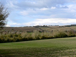
Alton is a civil parish in Wiltshire, England. The parish includes the adjacent villages of Alton Barnes and Alton Priors, and the nearby hamlet of Honeystreet on the Kennet and Avon Canal. It lies in the Vale of Pewsey about 6 miles (10 km) east of Devizes.
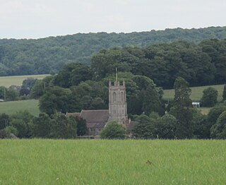
West Overton is a village and civil parish in the English county of Wiltshire, about 3.5 miles (5.6 km) west of Marlborough. The river Kennet runs immediately north of the village, separating it from the A4.
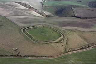
Liddington Castle, locally called Liddington Camp, is a late Bronze Age and early Iron Age hill fort in the English county of Wiltshire.

Grim's Ditch, Grim's Dyke or Grim's Bank is a name shared by a number of prehistoric bank and ditch earthworks. Enigmatic in both their naming and original function, examples are found across the chalk uplands of southern England.
Cunetio was a large walled town located in a river valley of the River Kennet in modern-day Wiltshire, England. The settlement, which is near the village of Mildenhall, was occupied from the 2nd century CE by Romano-British people until the post-Roman period. It was abandoned in the early 5th century.

Yarnbury Castle is the site of a multiphase, multivallate iron age hillfort near the village and civil parish of Steeple Langford, two miles along the A303 from Winterbourne Stoke, in Wiltshire. The site covers an area of 28.5 acres (11.5 ha), and has been extensively surveyed and investigated by the Royal Commission on the Historical Monuments of England (RCHME) in 1991, with finds of iron age and Romano-British pottery, iron age and Roman coins, and burials of human remains. There is much evidence of prolonged and extensive settlement of the site including for the evidence of around 130 separate structures of various sizes, most probably representing a mix of round houses, pits, and other features.

Figsbury Ring is an 11.2 hectare biological Site of Special Scientific Interest in Wiltshire, notified in 1975. It is owned and managed by the National Trust.

Vespasian's Camp is an Iron Age Hillfort close to the town of Amesbury, Wiltshire, England. The camp is less than 3 kilometres (2 mi) from the Neolithic and Bronze Age site of Stonehenge and was built on a hill next to the Stonehenge Avenue.

Marden Henge is the largest Neolithic henge enclosure discovered to date in the United Kingdom. The monument is northeast of the village of Marden, Wiltshire, within the Vale of Pewsey and between the World Heritage sites of Avebury and Stonehenge.

Battlesbury Camp is the site of an Iron Age bivallate hill fort on Battlesbury Hill near the town of Warminster in Wiltshire, South West England. Excavations and surveys at the site have uncovered various finds and archaeological evidence.

Scratchbury Camp is the site of an Iron Age univallate hillfort located on Scratchbury Hill, near the village of Norton Bavant in Wiltshire, England. The fort covers an area of 37 acres (15 ha) and occupies the summit of the hill on the edge of Salisbury Plain, with its four-sided shape largely following the natural contours of the hill.

Chiselbury is the site of an Iron Age univallate hillfort located in Wiltshire. The hillfort is sub-circular in plan, and encloses an area of approximately 10.5 acres (460,000 sq ft). It is defined by an earthen rampart up to 3.6 metres (12 ft) in height and an external ditch, up to a maximum of 1.6 metres (5.2 ft) in depth. A gap in the southeastern side of the rampart, and a corresponding causeway across the ditch, is thought to be the original entrance and is associated with a small 'D' shaped embanked enclosure, which is apparently visible on aerial photographs. Although the enclosure has subsequently been degraded by ploughing, it is still apparent as a series of low earthworks.

Bratton Castle is a bivallate Iron Age hill fort on Bratton Down, at the western edge of the Salisbury Plain escarpment. The hill fort comprises two circuits of ditch and bank which together enclose a pentagonal area of 9.3 hectares.

Wimble Toot is a burial mound or, possibly, a motte built near the village of Babcary, Somerset, England. It is a scheduled ancient monument with a list entry number of 1015279.

The Marietta Earthworks is an archaeological site located at the confluence of the Muskingum and Ohio Rivers in Washington County, Ohio, United States. Most of this Hopewellian complex of earthworks is now covered by the modern city of Marietta. Archaeologists have dated the ceremonial site's construction to approximately 100 BCE to 500 CE.
Castle Rings is a univallate hill fort in the parish of Donhead St Mary in Wiltshire in England. The fort is a Scheduled Ancient Monument, with a list entry identification number of 1005698. Castle Rings has been dated to the Iron Age and is situated at an altitude of 228 metres (748 ft) upon Upper Greensand sandstone beds. The main bulk of the fort enclosure lies within the boundaries of Donhead St Mary parish but some of the outlying earthworks are situated in the neighbouring Sedgehill and Semley parish. In the mid-1980s a metal detectorist unearthed a hoard of stater coins of the Durotriges tribe within the hill fort.

Caesar's Camp is an Iron Age hill fort straddling the border of the counties of Surrey and Hampshire in southern England. The fort straddles the borough of Waverley in Surrey and the borough of Rushmoor and the district of Hart, both in Hampshire. Caesar's Camp is a Scheduled Ancient Monument with a list entry identification number of 1007895. It lies approximately 3 kilometres (1.9 mi) north of the town of Farnham, and a similar distance west of Aldershot. The hillfort lies entirely within the Bourley and Long Valley Site of Special Scientific Interest. Caesar's Camp is a multivallate hillfort, a fort with multiple defensive rings, occupying an irregular promontory, with an entrance on the south side. The site has been much disturbed by military activity, especially at the southeast corner. The remains of the hillfort are considered to be of national importance.


