Related Research Articles

Fair Haven is a neighborhood in the eastern part of the city of New Haven, Connecticut, between the Mill and Quinnipiac rivers. The northeast section of the neighborhood is also known as Chatham Square.

City Point is an area in what is now The Hill neighborhood of the city of New Haven, Connecticut, located in the southwestern portion of the city. The City Point area was, when settled and through the 18th century, a relatively narrow peninsula extending south into New Haven Harbor, located where the West River empties into the harbor. Areas adjacent to the original peninsula have since been filled in, broadening its shoulders, and Interstate 95 has cut across it. The Oyster Point Historic District is a 26-acre (11 ha) historic district encompassing an area of relatively old buildings in City Point south of I-95.
Fair Haven Heights, or simply the Heights, is a residential and light industrial neighborhood in the eastern part of the city of New Haven, Connecticut, located east of the Quinnipiac River. Fair Haven Heights is not to be confused with the adjacent Fair Haven neighborhood west of the river. The area is bordered on the west by the Quinnipiac River, on the north by Route 80, on the east by the town of East Haven, and on the south by Ferry Street and Warwick Avenue. The main through routes are Quinnipiac Avenue, East Grand Avenue, and Eastern Street

This is intended to be a complete list of the properties and districts on the National Register of Historic Places in Fairfield County, Connecticut, United States. The locations of National Register properties and districts for which the latitude and longitude coordinates are included below may be seen in an online map.

Priscilla is a classic oyster dredging sloop and museum ship at the Long Island Maritime Museum. Built in 1888, it is the oldest surviving boat from the Great South Bay oyster fleet, and was designated a National Historic Landmark in 2006. It is berthed near the Modesty, another National Historic Landmark sloop.
J. C. Lore Oyster House, also known as J. C. Lore and Sons, Inc., Seafood Packing Plant, is located at 14430 Solomons Island Road South, in Solomons, Calvert County, Maryland. It is a large two story, rectangular frame industrial building constructed in 1934 as a seafood packing plant. It replaced a 1922 building that was destroyed by the 1933 Chesapeake Potomac hurricane. It is significant for its historical association with the commercial fisheries of Maryland's Patuxent River region, and architecturally as a substantially unaltered example of an early-20th century seafood packing plant. It has been adapted by the Calvert Marine Museum to house exhibits and many of its original spaces, artifacts, and records have been incorporated into them.
Prospect Hill is a neighborhood of the city of New Haven, Connecticut located in the north central portion of the city, directly north of Downtown New Haven. The neighborhood contains residences, institutional buildings of Albertus Magnus University and a portion of the main campus of Yale University, including the Science Hill area, the Hillhouse Avenue area and the Yale Peabody Museum. The City of New Haven defines the neighborhood to be the region bounded by the town of Hamden in the north, Winchester Avenue in the west, Munson Street/Hillside Place/Prospect Street in the southwest, Trumbull Street in the south, and Whitney Avenue in the east. Prospect Street is the main thoroughfare through the neighborhood.
The Prospect Hill Historic District is an irregularly-shaped 185-acre (75 ha) historic district in New Haven, Connecticut. The district encompasses most of the residential portion of the Prospect Hill neighborhood.

The Whitney Avenue Historic District is a historic district in the East Rock neighborhood of New Haven, Connecticut. It is a 203-acre (82 ha) district which included 1,084 contributing buildings when it was listed on the National Register of Historic Places in 1989.

The Winchester Repeating Arms Company Historic District is a historic district in New Haven, Connecticut that was listed on the National Register of Historic Places in 1988. It includes 867 properties, which "include 858 major structures and 131 notable outbuildings." Of these structures, 876 are buildings deemed to contribute to the historical and/or architectural significance of the area, and most of these are residential. However the center of the district is "dominated" by the 75-acre (30 ha) tract of the former Winchester Repeating Arms Company, which contains industrial buildings.

This is a list of National Register of Historic Places listings in New Haven, Connecticut.
Beaver Hills is a neighborhood in the city of New Haven, Connecticut. The older, east central portion of the neighborhood is listed on the National Register of Historic Places as the Beaver Hills Historic District. The southwest portion is a state historic district called the Fairlawn-Nettleton Historic District.
Marion is a neighborhood in the town of Southington, Connecticut. It is generally the area in the vicinity of the intersection of Route 322 and Marion Avenue just north of the Cheshire town line.
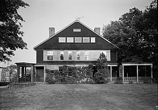
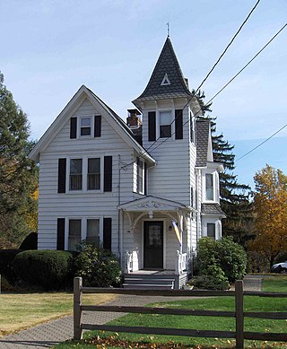
The Atwater–Ciampolini House, also known as the Charles Atwater House, is located at 321 Whitney Avenue in New Haven, Connecticut, at the southwest corner of intersection with Edwards Street. It is an important example of Shingle style architecture. It was designed by New York City-based architects Babb, Cook and Willard and was built during 1890-92. For many years the property had served as offices for Thompson and Peck, an insurance agency.

The Greenwich Avenue Historic District is a historic district representing the commercial and civic historical development of the downtown area of the town of Greenwich, Connecticut. The district was listed on the National Register of Historic Places on August 31, 1989. Included in the district is the Greenwich Municipal Center Historic District, which was listed on the National Register the year before for the classical revival style municipal buildings in the core of Downtown. Most of the commercial buildings in the district fall into three broad styles, reflecting the period in which they were built: Italianate, Georgian Revival, and Commercial style. The district is linear and runs north–south along the entire length of Greenwich Avenue, the main thoroughfare of Downtown Greenwich, between U.S. Route 1 and the New Haven Line railroad tracks.
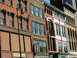
The Ninth Square Historic District encompasses a historically diverse and well-preserved part of the commercial area of Downtown New Haven, Connecticut. The district is bounded by Church, Court, State, and Crown Streets, and is centered on the intersection of Chapel and Orange Streets. The buildings in the district are mostly late-19th and early 20th commercial buildings, and includes a number of commercial buildings from the first half of the 19th century, a rarity in most of Connecticut's urban downtown areas. The district was listed on the National Register of Historic Places in 1984.

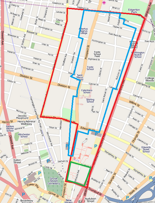
Quinnipiac River Historic District is a 313-acre (127 ha) historic district straddling the Quinnipiac River in the Fair Haven and Fair Haven Heights neighborhoods of New Haven, Connecticut. It encompasses most of the historic maritime village of Fair Haven, with a history dating back to the 18th century. It was listed on the National Register of Historic Places in 1984. At that time it included 524 contributing buildings, an inland wetland at the mouth of Hemingway Creek on the northeast corner of the district, and the Grand Avenue Swing Bridge over the Quinnipiac River connecting Fair Haven with Fair Haven Heights at the center of the district.

Historic Little England is a national historic district located at Hampton, Virginia. The district encompasses 87 contributing buildings in a streetcar suburb originally laid out in 1888. The primarily residential district includes notable examples of the Queen Anne and Colonial Revival styles. Notable dwellings include the house of developer Frank Darling, Reed House, and the James Darling II residence (1927).
The Durham Historic District encompasses a portion of the original historic settlement area of Durham, New Hampshire. It extends along Newmarket Road from its northern junction with Laurel Lane to a three-way junction with Main Street and Dover Road. From there it extends along Main Street to Madbury Road. This area, known in early colonial days as the Oyster River Plantation, for the Oyster River which bisects it, was first settled in 1649. It was developed in the 18th century as a significant shipbuilding center. The district was listed on the National Register of Historic Places in 1980.

The River Park Historic District encompasses the residential and civic heart of the city of Milford, Connecticut. Stretching along both sides of the Wepawaug River, the area includes part of Milford's earliest colonial settlement, and a series of parks that resulted from an early 20th-century beautification project. The district was listed on the National Register of Historic Places in 1986.
References
- ↑ Jan Cunningham (February 27, 1989). "National Register of Historic Places Inventory-Nomination: Oyster Point / Oyster Point Historic District / City Point". National Park Service. and Accompanying 22 photos, from 1989 (captions given page 23 of text document)