
Pajaro is an unincorporated community and census-designated place (CDP) in Monterey County, California. It is located on the south bank of the Pajaro River 5 miles (8 km) northeast of its mouth, at an elevation of 26 feet (7.9 m). The population was 2,882 at the 2020 census, down from 3,070 in 2010. The school district is in Santa Cruz County.

Watsonville is a city in Santa Cruz County, California, in the Monterey Bay Area of the Central Coast of California. The population was 52,590 at the 2020 census. Predominantly Latino and Democratic, Watsonville is a self-designated sanctuary city.

Caltrain is a California commuter rail line serving the San Francisco Peninsula and Santa Clara Valley. The southern terminus is in San Jose at Tamien station with weekday rush hour service running as far as Gilroy. The northern terminus of the line is in San Francisco at 4th and King Street. Caltrain has 28 regular stops, one limited-service weekday-only stop, one weekend-only stop (Broadway), and one football-only stop (Stanford). While average weekday ridership in 2019 exceeded 63,000, impacts of the COVID-19 pandemic have been significant: in August 2022, Caltrain had an average weekday ridership of 18,600 passengers.
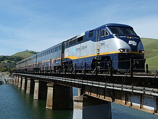
The Capitol Corridor is a 168-mile (270 km) passenger train route in Northern California operated by Amtrak between San Jose, in the Bay Area, and Auburn, in the Sacramento Valley. The route is named after the two points most trains operate between, San Jose and Sacramento. The route runs roughly parallel to I-880 and I-80. Some limited trips run between Oakland and San Jose. A single daily round trip runs between San Jose and Auburn, in the foothills of the Sierra Nevada. Capitol Corridor trains started in 1991.

Central California is generally thought of as the middle third of the U.S. state of California, north of Southern California and south of Northern California. It includes the northern portion of the San Joaquin Valley, part of the Central Coast, the central hills of the California Coast Ranges and the foothills and mountain areas of the central Sierra Nevada.

The Santa Cruz, Big Trees and Pacific Railway is operated as a seasonal tourist attraction in Northern California, also referred to as the "Beach Train". Its partner line, the Roaring Camp & Big Trees Narrow Gauge Railroad, is a heritage railroad.
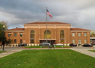
San Jose Diridon station is the central passenger rail depot for San Jose, California. It also serves as a major intermodal transit center for Santa Clara County and Silicon Valley. The station is named after former Santa Clara County Supervisor Rod Diridon Sr.
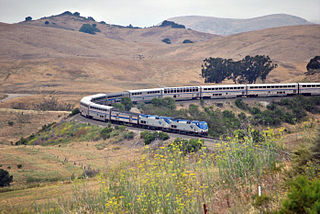
The Coast Line is a railroad line between Burbank, California and the San Francisco Bay Area, roughly along the Pacific Coast. It is the shortest rail route between Los Angeles and the Bay Area. Though not as busy as the Surf Line, the continuation of the Coast Line southbound to San Diego, it still sees freight movements and lots of passenger trains. The Pacific Surfliner, which runs from the San Diego Santa Fe Depot to San Luis Obispo via Union Station in Los Angeles, is the third busiest Amtrak route, and the busiest outside of the Northeast Corridor between Washington D.C. and Boston.

Monterey–Salinas Transit (MST) is the public transit system for Monterey County, California. Service is primarily to the greater Monterey and Salinas areas, but extends as far south as Paso Robles and Big Sur and as far north as Watsonville. Most lines follow a hub-and-spoke system, connecting at hubs in Monterey or Salinas. In 2023, the system had a ridership of 2,470,300, or about 8,100 per weekday as of the fourth quarter of 2023.

The Pajaro River is a U.S. river in the Central Coast region of California, forming part of the border between San Benito and Santa Clara Counties, the entire border between San Benito and Santa Cruz County, and the entire border between Santa Cruz and Monterey County. Flowing roughly east to west, the river empties into Monterey Bay, west of Watsonville, California.
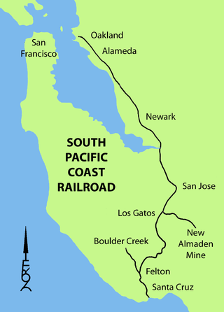
The South Pacific Coast Railroad (SPC) was a 3 ft narrow gauge steam railroad running between Santa Cruz, California, and Alameda, with a ferry connection in Alameda to San Francisco. The railroad was created as the Santa Clara Valley Railroad, founded by local strawberry growers as a way to get their crops to market in San Francisco and provide an alternative to the Southern Pacific Railroad. In 1876, James Graham Fair, a Comstock Lode silver baron, bought the line and extended it into the Santa Cruz Mountains to capture the significant lumber traffic coming out of the redwood forests. The narrow-gauge line was originally laid with 52-pound-per-yard (26 kg/m) rail on 8-foot (2.44 m) redwood ties; and was later acquired by the Southern Pacific and converted to 4 ft 8+1⁄2 instandard gauge.

Gilroy station is a Caltrain station located in Gilroy, California, United States. It is the southernmost terminus of the Caltrain system, and is only served during weekday rush hours in the peak direction, with trains going toward San Francisco in the morning and returning southbound in the evening. The station building was constructed by the Southern Pacific Railroad in 1918 and restored in 1998. Future plans call for extended Amtrak Capitol Corridor service, as well as California High-Speed Rail trains, to also stop at Gilroy. The station was named to the National Register of Historic Places in 2019 as Gilroy Southern Pacific Railroad Depot.

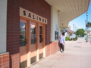
Salinas station, also known as the Salinas Intermodal Transportation Center, is an intermodal transit center in downtown Salinas, California, United States. As a transit hub, the facility is a passenger rail station and bus station.
The Santa Cruz Railroad was a narrow gauge railroad that ran 21 miles from Santa Cruz to Pajaro, California. It started operation in 1874, running from the east bank of the San Lorenzo River to Soquel, California. With completion of a bridge over the San Lorenzo, it began operation over its full length in 1876 and was sold in foreclosure in 1881.
The Santa Cruz and Monterey Bay Railroad (SCMB), or Santa Cruz Branch Rail Line (SCBRL), is a historic railway running through Santa Cruz County, California. It once ran operationally from Davenport to the Watsonville Junction where it connected to the Union Pacific Coast Line. Over the years it has had many splays and connections to other local railroads over, through, and around the Santa Cruz Mountains. It is still active today, including a connection with the Roaring Camp Railroads line that makes regular trips between Felton and the Santa Cruz Beach Boardwalk.

The Suntan Special was a summer excursion train service operated by the Southern Pacific Railroad between San Francisco and Santa Cruz, California, from 1927 to 1959.
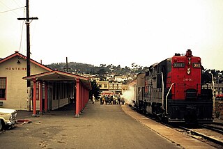
Monterey station was a train station in Monterey, California located close to Fisherman's Wharf. Originally served by the Monterey & Salinas Valley Railroad, the line was purchased by Southern Pacific on September 29, 1879. Southern Pacific constructed a new station building in 1921. Train service ended with the cancellation of the Del Monte after April 30, 1971, when Amtrak took over passenger rail services in the United States.
Castroville Multimodal Station is a future train station in Castroville, California. It is planned to serve both Caltrain and Amtrak California's Capitol Corridor trains as part of the Monterey County Rail Extension. The station will be located along Del Monte Avenue between Blackie Road and Wood Street. It is expected to open after track improvements in the area and commencement of service to Salinas.
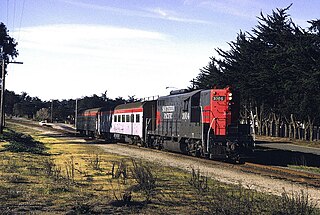
The Monterey Branch Line is a railway line located in Monterey County, California. It runs 16 miles (26 km) between Castroville, where it connects to the Union Pacific Coast Line, and Monterey, formerly running as far as Pacific Grove. It is roughly paralleled by California State Route 1 and is active to Sand City as of 2020.
The Monterey County Rail Extension is a planned commuter rail extension that would bring Caltrain passenger service south of its existing Gilroy, California terminus to Salinas in Monterey County, using the existing Coast Line owned by Union Pacific (UPRR). Implementation of the rail extension will occur over three phases, starting from Salinas and moving north. When construction is complete, there will be four trains operated over the extended line per weekday: two northbound trains that depart from Salinas and travel to San Francisco in the morning, and two southbound trains that return to Salinas in the afternoon.