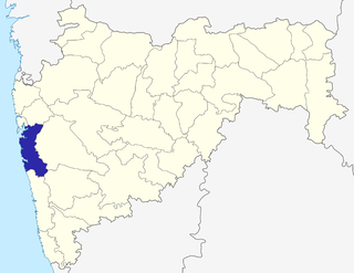
Panvel is a locality in Raigad district of Maharashtra in Konkan Division, and is a node of Navi Mumbai city. It is highly populated due to its closeness to Mumbai. Panvel is located in the Mumbai Metropolitan Region. Panvel is the first Municipal Corporation in Raigad and the 27th Municipal corporation of Maharashtra State.

Neral is a town in Raigad district in the Indian state of Maharashtra. It is 83 km from Mumbai-South and 42 km from Panvel in the Karjat tehsil. It is a rapidly developing city of a Raigad district which is well connected to Panvel, Mumbai, Thane and Pune. Neral along with Karjat is also known as Eastern Mumbai District.

Varadvinayak, also spelt as Varadavinayaka, is one of the Ashtavinayak temples of the Hindu deity Ganesha. It is located in Mhad village situated in Khalapur taluka near Karjat and Khopoli of Raigad District, Maharashtra, India. The temple was built (restored) by Peshwa General Ramji Mahadev Biwalkar in 1725AD.

Mahadpronunciation (help·info) is a city in Raigad district(formerly Kulaba district) situated in the North Konkan region of Maharashtra state, India. It is located 108.5km from District's Headquarter Alibag, and 167km from Mumbai state capital of Maharashtra and Economic capital of India, towards Western Coast.

Raigad is a hill fort situated in the Mahad, Raigad district of Maharashtra, India. The Raigad Fort was seized by Chhatrapati Shivaji Maharaj and made it his capital in 1674 when he was crowned as the King of a Maratha Kingdom which later developed into the Maratha Empire, eventually covering much of western and central India.

Mangaon is a small town in the Konkan region of Maharashtra, India. It is located in the Raigad district, 80 kilometres from Alibaug headquarters, and 119 kilometres from the state capital of Mumbai, towards the Panjim side.

Pen is a town and taluka in Raigad district of Indian state of Maharashtra. It is well-known for world class Ganesh idols. It is geographical and cultural center of Raigad district.
Khambeshwarwadi No.2 is a village in Poladpur taluka in Raigad district of state of Maharashtra, India.
Avchitgad is a fort located in the Sahyadri ranges of Maharashtra. The fort is situated near Roha in the Raigad district. At the base of this fort is a village called Medha and Padam - Kharapti.
Shirdhon is a small village located in near Panvel in Raigad district in Maharashtra, India. It lies on Mumbai Goa National Highway NH 17. The nearest Town and Rail Head is Panvel. Karnala fort and Karnala Bird Sanctuary are just 4 km away from Shirdhon. Shirdhon is having a village panchayat. Rice is the main agriculture over here.
Khalapur taluka is a [taluka] in [Raigad district] of Maharashtra an Indian state. The headquarters of this taluka is Khalapur village. This taluka belongs to Karjat sub-division, and comprises 141 villages, 3 revenue circles and 20 sajas. 56 villages of this taluka come under Navi Mumbai Airport Influence Notified Area (NAINA).
Karjat taluka is a taluka in Raigad district of Maharashtra an Indian state.
Mahad taluka is a taluka in Raigad district of Maharashtra an Indian state.
Mhasala Taluka is a taluka in Raigad district of Maharashtra an Indian state. In Mhasala taluka under villages are follows: Banoti,kharasai,revali,tondsure,agarwada, pedambe,saklap,jangamvadi, varavathane,ganeshnagar
Panvel taluka is a taluka in Raigad district of Maharashtra state in Konkan division.
Pen taluka is a taluka in Raigad district of Maharashtra an Indian state.
Shrivardhan taluka is a taluka in Raigad district of Maharashtra an Indian state. Town of Shrivardhan is the administrative headquarters of this taluka.
Sudhagad - Pali taluka is a taluka in Raigad district of Maharashtra an Indian state.
Uran taluka is a taluka in Raigad district of Maharashtra an Indian state.