
Palo Verde is a census-designated place (CDP) in Imperial County, California. Its name comes from the native desert tree, Palo Verde, which in turn takes its name from the Spanish for stick (palo) and green (verde), sharing its name with the Palo Verde Valley, the valley it is located. Therefore, its name literally means "green stick."

Palos Verdes Estates is a city in Los Angeles County, California, United States, situated on the Palos Verdes Peninsula. The city was master-planned by the noted American landscape architect and planner Frederick Law Olmsted Jr. The city is located along the Southern California coastline of the Pacific Ocean.

Rancho Palos Verdes is a city in Los Angeles County, California atop the Palos Verdes Hills and bluffs of the Palos Verdes Peninsula. A suburb of Los Angeles, it is known for expensive homes amidst large tracts of open space with expansive views of the Pacific Ocean. Rancho Palos Verdes is translated as "Ranch of Green Sticks", probably referring to the willows in the northeastern part of Bixby Slough shown on earlier maps.

Rolling Hills is a city on the Palos Verdes Peninsula, in Los Angeles County, California, United States. Rolling Hills is 24 hour guard-gated community with private roads with three entry gates. Homes are single-story 19th century California ranch or Spanish haciendas exemplified by architect Wallace Neff. Incorporated in 1957, Rolling Hills maintains a rural and equestrian character, with no traffic lights, multi-acre lots with ample space between homes, and wide equestrian paths along streets and property lines.

Rolling Hills Estates is a city in Los Angeles County, California, United States. On the northern side of the Palos Verdes Peninsula, facing Torrance, Rolling Hills Estates is mostly residential. Incorporated in 1957, Rolling Hills Estates has many horse paths. The population was 8,067 at the 2010 census, up from 7,676 at the 2000 census. In 2018 the population rose to 8,141.

The Palos Verdes Peninsula is a landform and a geographic sub-region of the Los Angeles metropolitan area, within southwestern Los Angeles County in the U.S. state of California. Located in the South Bay region, the peninsula contains a group of affluent cities in the Palos Verdes Hills, including Palos Verdes Estates, Rancho Palos Verdes, Rolling Hills and Rolling Hills Estates. The South Bay city of Torrance borders the peninsula on the north, the Pacific Ocean is on the west and south, and the Port of Los Angeles is east. The population of the Palos Verdes Peninsula is 42,364.
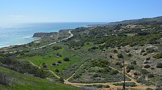
The Portuguese Bend region is the largest area of natural vegetation remaining on the Palos Verdes Peninsula, in Los Angeles County, California. Though once slated for development, the area is geologically unstable and is unsuitable for building.

Palos Verdes Peninsula High School is one of three public high schools on the Palos Verdes Peninsula in Rolling Hills Estates in Los Angeles County, California, USA,. Located near the Peninsula Promenade mall and near Hawthorne Boulevard and Silver Spur Road, Peninsula High serves the communities of Rolling Hills Estates, Rolling Hills, Rancho Palos Verdes, and Palos Verdes Estates.

The Palo Verde Generating Station is a nuclear power plant located near Tonopah, Arizona, in western Arizona. It is located about 45 miles (72 km) due west of downtown Phoenix, Arizona, and it is located near the Gila River, which is dry save for the rainy season in late summer.
Palos Verdes Peninsula Unified School District (PVPUSD) is a school district headquartered in Palos Verdes Estates, California.

Palo Verde is a small populated place in Maricopa County, Arizona, United States. It is located about 40 miles (64 km) west of Phoenix, and 6 miles (9.7 km) southwest of downtown Buckeye.

Frank Arthur Vanderlip Sr. was an American banker and journalist. He was president of the National City Bank of New York from 1909 to 1919, and Assistant Secretary of the Treasury from 1897 to 1901. Vanderlip is known for his part in founding the Federal Reserve System and for founding the first Montessori school in the United States, the Scarborough School and the group of communities in Palos Verdes, California.

The Palo Verde Mountains are a mountain range in northeastern Imperial County, California.
The Palos Verdes Hills are a low mountain range on the southwestern coast of Los Angeles County, California. They sit atop the Palos Verdes Peninsula, a sub-region of the Los Angeles metropolitan area.

Chowigna is a former Tongva-Gabrieleño Native American settlement in Los Angeles County, California.
The Palos Verdes Peninsula Transit Authority is the primary provider of mass transportation in the Los Angeles suburbs of Rancho Palos Verdes, Palos Verdes Estates, Rolling Hills, and Rolling Hills Estates, California. Six color routes provide local service, while Routes 225 and 226 both allow for connections in Torrance and Route 226 also continues into the Los Angeles district of San Pedro.

Palos Verdes Golf Club is a private golf and social club located in Palos Verdes Estates, CA.

The Palo Verde Valley is located in the Lower Colorado River Valley, next to the eastern border of Southern California with Arizona, United States. It is located on the Colorado Desert within the Sonoran Desert south of the Parker Valley. Most of the valley is in Riverside County, with the southern remainder in Imperial County. La Paz County borders to the east on the Colorado River.
The International Bilingual School was an international bilingual day school in Palos Verdes Estates, California, in the Los Angeles metropolitan area, serving students in Kindergarten through grade 9. It was founded by Tadao Hara. The school's name later changed to International School of Los Angeles (ISLA), and it was later located in Torrance.
