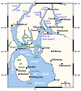
The Firth of Clyde is the mouth of the River Clyde. It is located on the west coast of Scotland and constitutes the deepest coastal waters in the British Isles. The firth is sheltered from the Atlantic Ocean by the Kintyre peninsula, which encloses the outer firth in Argyll and Ayrshire. The Kilbrannan Sound is a large arm of the Firth of Clyde, separating the Kintyre Peninsula from the Isle of Arran. Within the Firth of Clyde is another major island – the Isle of Bute. Given its strategic location at the entrance to the middle and upper Clyde, Bute played a vital naval military role during World War II.

Lamlash is a village on the Isle of Arran, in the Firth of Clyde, Scotland. It lies three miles south of the island's main settlement and ferry port Brodick, in a sheltered bay on the island's east coast, facing the Holy Isle. Lamlash is the seat of Arran's local government offices, and is also the location of the island's only police station, secondary school and hospital. In common with the rest of the island, the village's main industry is tourism and the public sector is also an important employer. Lamlash has an RNLI Lifeboat station with a B class Atlantic 75 lifeboat, covering the inshore waters around the coast of Arran, and in summer, there is a regular ferry service from Lamlash harbour to Holy Isle. The village has several buildings of historical interest, including Hamilton Terrace, which consists of two rows of idyllic single storey-and-attic cottages on the Lamlash seafront, arranged in pairs.
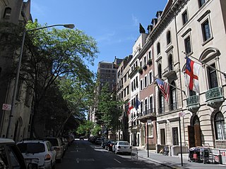
The Upper East Side, sometimes abbreviated UES, is a neighborhood in the borough of Manhattan in New York City, bounded by 96th Street to the north, the East River to the east, 59th Street to the south, and Central Park/Fifth Avenue to the west. The area incorporates several smaller neighborhoods, including Lenox Hill, Carnegie Hill, and Yorkville. Once known as the Silk Stocking District, it has long been the most affluent neighborhood in New York City.

The County of Bute, also known as Buteshire, is a historic county and registration county of Scotland.

Dreghorn is a village in North Ayrshire, Scotland, 3.5 kilometres east of Irvine town centre, on the old main road from Irvine to Kilmarnock. It is sited on a ridge between two rivers. As archaeological excavations near the village centre have found a significant neolithic settlement provisionally dated to around 3500 BC, as well as medieval structures, scholars have suggested that Dreghorn could be Britain's oldest continuously inhabited village. Both Irvine and Dreghorn have grown in size and they are now separated by the Annick Valley Park, which incorporates a footpath and National Cycle Route 73 on the route of the disused Irvine to Busby railway line. It had an estimated population of 3,450 in 2020.

The Glasgow East End Regeneration Route (GEERR) is a new road in the East End of Glasgow, Scotland. The first phase was opened in 2011 with the second phase opened in mid-2012; these two phases are officially known as the A728 Clyde Gateway. A third phase from the Parkhead Bypass to Provan (M8/M80) was scheduled for construction in 2018, but may not now be built. Another nearby road in the city also has the A728 designation.
Cassop-cum-Quarrington is a civil parish in County Durham, England. According to the 2001 census it had a population of 4,735, increasing to 5,219 at the 2011 census.
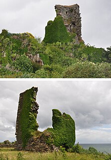
Kildonan Castle stands in the small village of Kildonan on the southern coast of the Isle of Arran in Scotland. The castle's name is derived from the name of a former resident, Saint Donan, who is said to be buried on the island.

Kincaidston is a housing scheme in the town of Ayr in South Ayrshire, Scotland.
Moredun is a district in the south-east of Edinburgh, the capital of Scotland. It is east of Liberton, while Craigour is situated just to its north.

Kildonan is a village on the south coast of the Isle of Arran in the Firth of Clyde, Scotland. The village is within the parish of Kilmory.
Deaconsbank is a neighbourhood in the Scottish city of Glasgow. It is situated south of the River Clyde. The main feature of the area, which falls into the Greater Pollok ward of Glasgow City Council and directly borders the East Renfrewshire council region, is an estate of around 639 private houses built in the late 1970s by Barratt Developments, prior to which the area was open farmland. Deaconsbank is bordered by the M77 motorway to the west and by Rouken Glen Park and golf course to the east. The northern parts of the suburban town of Newton Mearns are a short distance to the south, as is Patterton railway station.

Oronsay is an uninhabited island in Loch Sunart, Scotland.
Woodhall is a housing scheme in the lower east end of Port Glasgow, Inverclyde in Scotland. It stands on land once occupied by Woodhall mansion and estate. The mansion stood where St Martin's church now stands on Mansion Avenue. Woodhall is on a north facing slope, overlooking the River Clyde and is bounded on the north by the River Clyde, on the south by Parkhill Avenue, on the west by Port Glasgow cemetery and on the east by what is now the Castlebank housing estate which is on the site of the former Broadfield Hospital.
The master plan of Jumeirah Garden City refers to the re-development of a 9,000,000-square-metre (97,000,000 sq ft) land area, conceptualized to be a part of the 2015 strategic plan for Dubai. The development consists of 12 districts with an envision built up area of 14,000,000 square metres (150,000,000 sq ft). The Jumeirah Garden City aims to cater to a population of 50,000 to 60,000 residents. The project will cost approximately Dh350 billion . The announcement of the project coincided with the global financial crisis, and the construction of the project was put on hold due to global financial crisis.

Glenapp Castle, formerly the family seat of the Earl of Inchcape, is now a luxury hotel and restaurant located about 1+1⁄2 miles southeast of Ballantrae, South Ayrshire, Scotland.

Glenmavis is a village in the North Lanarkshire area of Scotland. It is situated about 2 miles north-west of Airdrie on the B802 road. It has a population of around 2,510 (mid-2020 est.)

Hudson Park and Boulevard is a greenway and boulevard in Hell's Kitchen, Manhattan in New York City, being built as part of the Hudson Yards Redevelopment Project. It lies between 10th and 11th Avenues. The park, officially called Bella Abzug Park, is located in the median of the boulevard, which consists of two one-way roads that run parallel to each other.
Three lighthouses can be found around the shores of the Isle of Arran in the Firth of Clyde. One is located on the island of Pladda in the south and the other two can be found on Holy Island in Lamlash Bay to the east of Arran. All three are still in service and maintained by the Northern Lighthouse Board. They are now fully automatic since the electrification of both lighthouses on Holy Isle in 1977.

Moss Farm Road Stone Circle is the remains of a Bronze Age burial cairn, surrounded by a circle of stones. It is located near Machrie on the Isle of Arran in Scotland.

 The foot of Arran Avenue
 Oronsay Avenue from Kilmacolm Road
 Pladda Avenue
 Bute Avenue
 Coll Avenue
 Struthers Memorial Church and Park Farm Post Office


