Parrano

Last updated
Parrano
Comune
Comune di Parrano
Parrano.jpg
Italy provincial location map 2015.svg
Red pog.svg
Parrano
Location of Parrano in Italy
Coordinates: 42°52′N12°7′E / 42.867°N 12.117°E / 42.867; 12.117 Coordinates: 42°52′N12°7′E / 42.867°N 12.117°E / 42.867; 12.117
Country Italy
Region Umbria
Province Terni (TR)
Frazioni Cantone, Frattaguida, Pievelunga
Government
  Mayor Valentino Filippetti
Area
  Total 39.9 km2 (15.4 sq mi)
Elevation 441 m (1,447 ft)
Population (1 January 2016) [1]
  Total 534
  Density 13/km2 (35/sq mi)
Demonym(s) Parranesi
Time zone CET (UTC+1)
  Summer (DST) CEST (UTC+2)
Postal code05010
Dialing code 0763
Website Official website

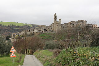
Parrano is a comune (municipality) in the Province of Terni in the Italian region Umbria, located about 35 km southwest of Perugia and about 50 km northwest of Terni.

<i>Comune</i> third-level administrative divisions of the Italian Republic

The comune is a basic administrative division in Italy, roughly equivalent to a township or municipality.

Province of Terni Province of Italy

The Province of Terni is the smaller of the two provinces in the Umbria region of Italy, comprising one-third of both the area and population of the region. Its capital is the city of Terni. The province came into being in 1927, when it was carved out of the original unitary province of Umbria.

Italy republic in Southern Europe

Italy, officially the Italian Republic, is a European country consisting of a peninsula delimited by the Italian Alps and surrounded by several islands. Located in the middle of the Mediterranean sea and traversed along its length by the Apennines, Italy has a largely temperate seasonal climate. The country covers an area of 301,340 km2 (116,350 sq mi) and shares open land borders with France, Slovenia, Austria, Switzerland and the enclaved microstates of Vatican City and San Marino. Italy has a territorial exclave in Switzerland (Campione) and a maritime exclave in the Tunisian sea (Lampedusa). With around 60 million inhabitants, Italy is the fourth-most populous member state of the European Union.

Parrano borders the following municipalities: Ficulle, Montegabbione, San Venanzo.

Ficulle Comune in Umbria, Italy

Ficulle is a comune (municipality) in the Province of Terni in the Italian region Umbria, located about 40 km southwest of Perugia and about 60 km northwest of Terni.

Montegabbione Comune in Umbria, Italy

Montegabbione is a comune (municipality) in the Province of Terni in the Italian region Umbria, located about 35 km southwest of Perugia and about 60 km northwest of Terni.

San Venanzo Comune in Umbria, Italy

San Venanzo is a comune (municipality) in the Province of Terni in the Italian region Umbria, located about 30 km (19 mi) southwest of Perugia and about 45 km (28 mi) northwest of Terni.

Related Research Articles

Arrone Comune in Umbria, Italy

Arrone is a comune (municipality) in the Province of Terni in the Italian region Umbria, located about 70 km southeast of Perugia and about 10 km east of Terni in the Valnerina.

Attigliano Comune in Umbria, Italy

Attigliano is a comune (municipality) in the Province of Terni in the Italian region Umbria, located about 70 km south of Perugia and about 30 km west of Terni. Attigliano has the lowest elevation of any municipality located in Umbria.

Baschi Comune in Umbria, Italy

Baschi is a comune (municipality) in the Province of Terni in the Italian region Umbria, located about 50 km southwest of Perugia and about 35 km northwest of Terni.

Calvi dellUmbria Comune in Umbria, Italy

Calvi dell'Umbria is a comune (municipality) in the Province of Terni in the Italian region Umbria, located about 80 km south of Perugia and about 20 km southwest of Terni.

Castel Giorgio Comune in Umbria, Italy

Castel Giorgio is a comune (municipality) in the Province of Terni in the Italian region Umbria, located about 60 km southwest of Perugia and about 60 km northwest of Terni on the Alfine Highland, facing the Lake Bolsena.

Fabro Comune in Umbria, Italy

Fabro is a comune (municipality) in the Province of Terni in the Italian region Umbria, located about 40 km southwest of Perugia and about 60 km northwest of Terni.

Guardea Comune in Umbria, Italy

Guardea is a comune (municipality) in the Province of Terni in the Italian region Umbria, located about 60 km south of Perugia and about 30 km west of Terni.

Montecastrilli Comune in Umbria, Italy

Montecastrilli is a comune (municipality) in the Province of Terni in the Italian region of Umbria, located about 50 km south of Perugia and about 15 km northwest of Terni.

Montecchio Comune in Umbria, Italy

Montecchio is a comune (municipality) in the Province of Terni in the Italian region Umbria, located about 50 km south of Perugia and about 30 km northwest of Terni.

Montefranco Comune in Umbria, Italy

Montefranco is a comune (municipality) in the Province of Terni in the Italian region Umbria, located about 70 km southeast of Perugia and about 10 km northeast of Terni. As of 31 December 2004, it had a population of 1,329 and an area of 10.1 km².

Penna in Teverina Comune in Umbria, Italy

Penna in Teverina is a comune (municipality) in the Province of Terni in the Italian region Umbria, located about 70 km south of Perugia and about 25 km southwest of Terni.

Polino Comune in Umbria, Italy

Polino is a comune (municipality) in the Province of Terni in the Italian region Umbria, located about 70 km southeast of Perugia and about 15 km east of Terni. As of 31 December 2004, it had a population of 275 and an area of 19.5 km².

Porano Comune in Umbria, Italy

Porano is a comune (municipality) in the Province of Terni in the Italian region Umbria, located about 50 km southwest of Perugia and about 45 km northwest of Terni. As of 31 December 2004, it had a population of 1,867 and an area of 13.5 km².

Avigliano Umbro Comune in Umbria, Italy

Avigliano Umbro is a comune (municipality) in the Province of Terni in the Italian region Umbria, located about 50 km south of Perugia and about 20 km northwest of Terni. As of 2011 census its population was of 2,568.

Castel SantAngelo, Lazio Comune in Latium, Italy

Castel Sant'Angelo is a comune (municipality) in the Province of Rieti in the Italian region Lazio, located about 70 kilometres (43 mi) northeast of Rome and about 12 kilometres (7 mi) east of Rieti.

Contigliano Comune in Latium, Italy

Contigliano is a comune (municipality) in the Province of Rieti in the Italian region Latium, located about 60 kilometres (37 mi) northeast of Rome and about 8 kilometres (5 mi) west of Rieti.

Labro Comune in Latium, Italy

Labro is a comune (municipality) in the Province of Rieti in the Italian region Latium, located about 70 kilometres (43 mi) northeast of Rome and about 15 kilometres (9 mi) northwest of Rieti. As of 31 December 2004, it had a population of 374 and an area of 11.4 square kilometres (4.4 sq mi). There is an ex-Francescan monastery located in Labro that is run by the Colle di Costa hotel. Beginning in April 2010, the hotel will share this space with the Art Monastery Project, an international arts production organization that will animate the town with regular performances and exhibitions.

References

  1. All demographics and other statistics: Italian statistical institute Istat.